Compound-specific stable isotopes and radioisotopes hold the key to identifying and apportioning major sources of eroded soils, and their persistence, in the Bay of Islands.
Catchment deforestation and conversion to agricultural land use in New Zealand since the mid-1800s have substantially increased soil-erosion rates, adversely affecting the aquatic receiving environments. Catchment managers require specific information to mitigate the multi-faceted effects of soil erosion. In particular, they need to know the major sources and fate of eroded soils, and how persistent those sources are.
Sediment records preserved in aquatic sinks, such as estuaries, can be used to address these questions as they integrate the long-term environmental history of a catchment. A NIWA study used compound-specific stable isotopes (CSSI) in combination with radioisotopes to identify and apportion major sources of eroded soils and their persistence in the Bay of Islands, New Zealand (Figure 1).
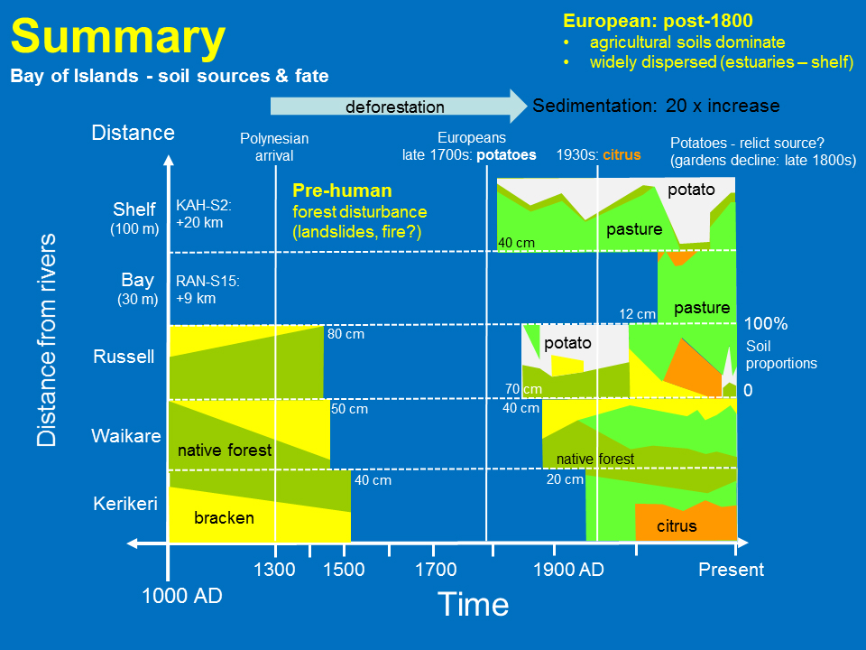
Human activities substantially increased soil erosion in the Bay of Islands catchment, with average sediment deposition rates increasing from pre-human values of ~23,000t/yr to ~500,000 t/yr over the last century. The cores also show a trend of decreasing sedimentation with distance seaward from major river sources.
The CSSI d13C signatures indicate high proportions of bracken-labelled soils in pre-human sediments, suggesting that natural disturbance of the landscape was a feature of this system. Soils associated with deforestation and land conversion to agriculture (e.g., dry-stock pasture, root crops, citrus) enter the sedimentary record from the mid-1800s (Figure 2). In fringing estuaries, soils eroded from dry-stock pasture and citrus orchards have dominated sedimentation over the last several decades.
Further offshore in the inner bay, soils eroded from dry-stock pasture account for more than 90 per cent of the sediment deposited since the early 1960s. The impacts of soil erosion extend onto the continental shelf, where soils derived from dry-stock pasture and potato cropping dominate sedimentation since the early 1800s.
The persistence and dominance of soils eroded from pastoral agriculture and horticulture indicate that these land uses are largely driving environmental changes in the receiving marine environment. Conversely, these findings also describe a chronic loss of productive soils over the last 150 years.
Sediment records preserved in receiving environments provide a long-term perspective on these issues, which can inform catchment and environmental management.
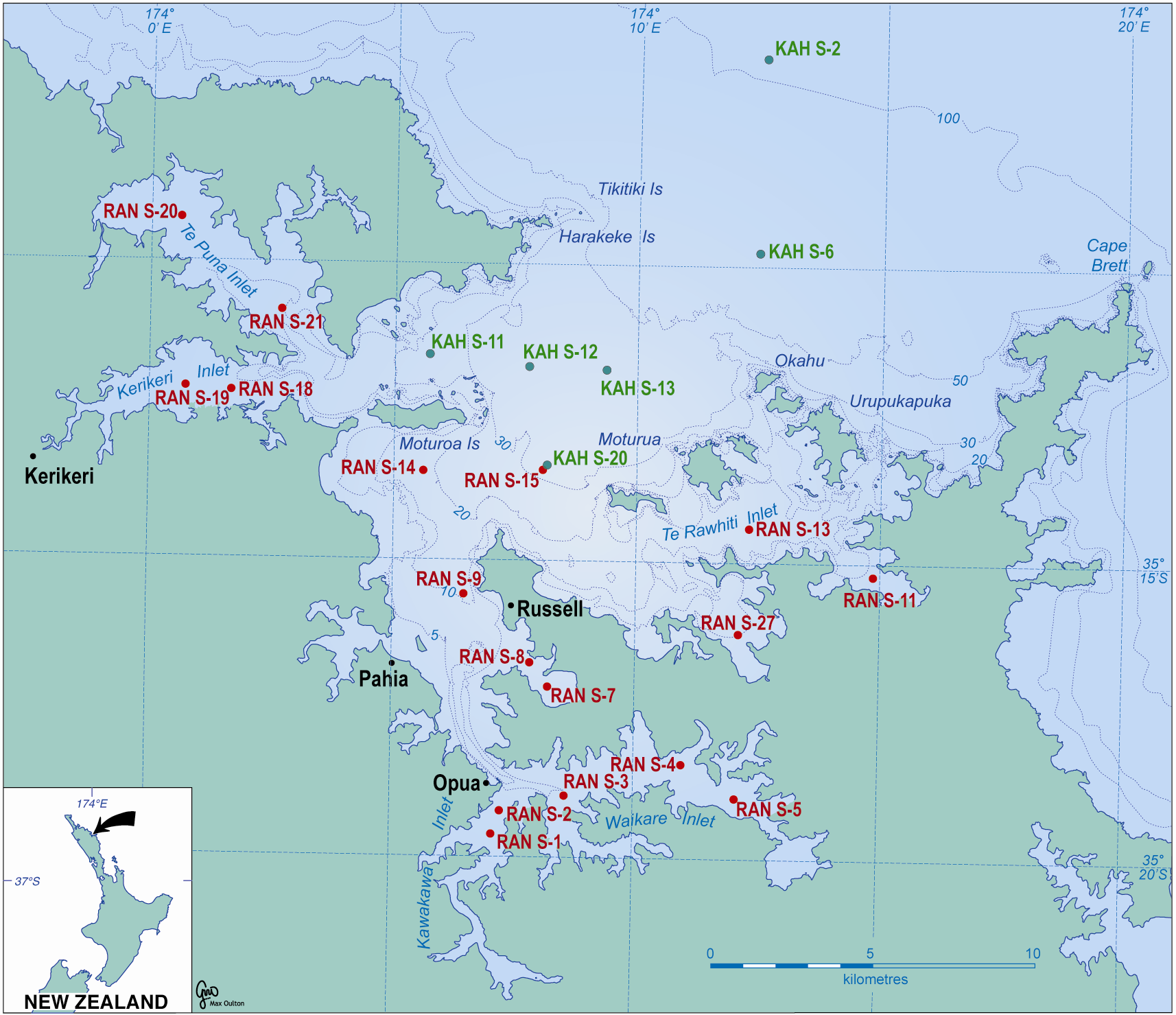
Bay of Islands, Northland, New Zealand. Location of sediment cores used to determine sedimentation rates and fate of eroded soils.
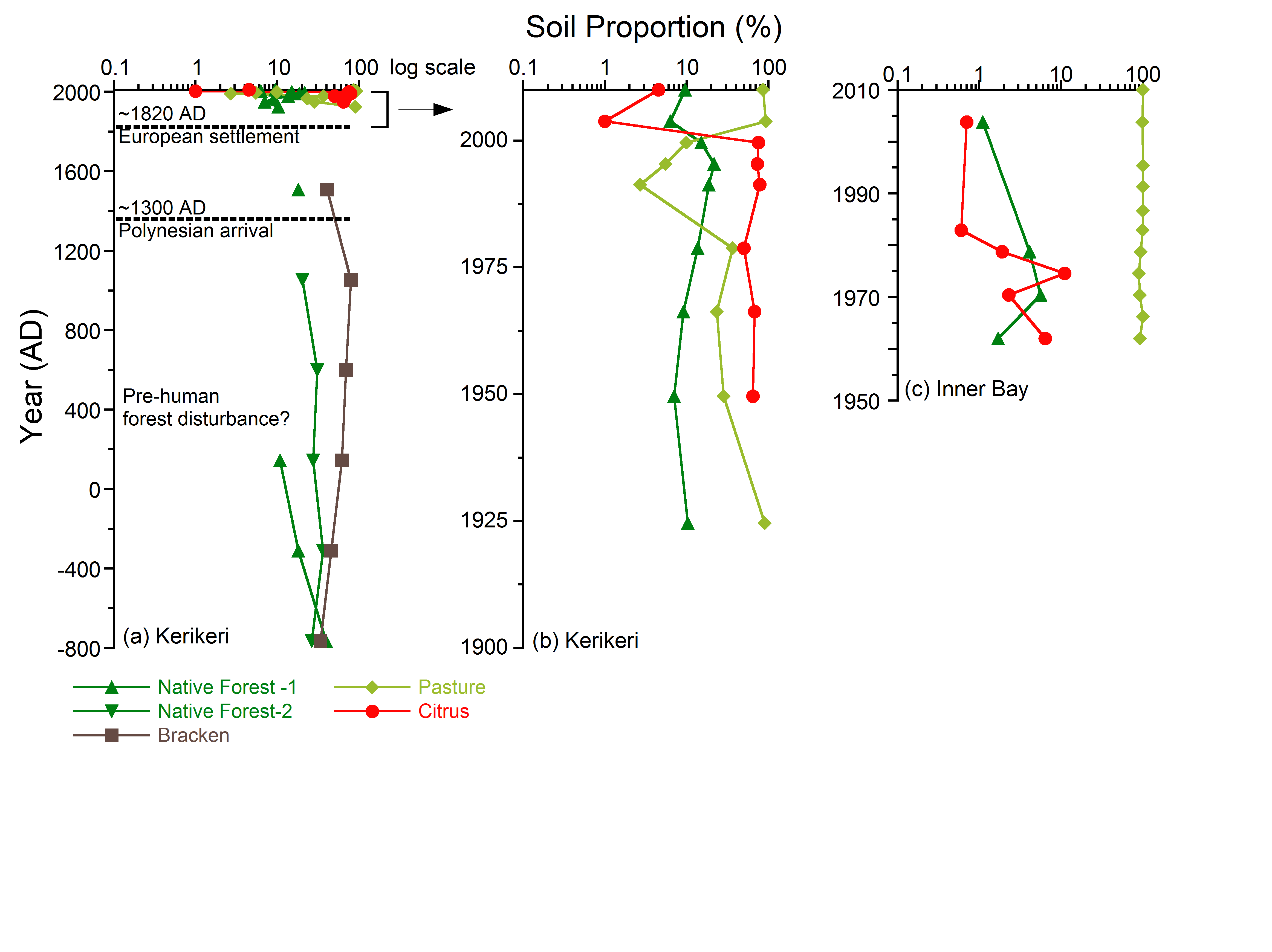
Reconstruction of temporal changes in terrigenous-sediment sources accumulating in the Bay of Islands system: (a) Kerikeri Inlet (site RAN S-18, 800 BC – 2010AD); (b) Kerikeri Inlet (post-1900); (c) Inner Bay of Islands, water depth 30 m (RAN S-15).