PDF of this article (137 KB)


Tracking snapper origins
Recent research on snapper stock on the North Island west coast demonstrates the central importance of Kaipara Harbour, and the biogenic habitat fish nurseries within it, to the wider west coast ecosystem. In 2003 we collected juvenile snapper from the seven main estuaries on this coast, and chemically analysed their otoliths (ear bones). Using eight elements (Li, Na, Mg, Mn, Zn, Rb, Sr, Ba) we created a statistical ‘signature library’ for their natal estuaries; this allowed us to distinguish fish from Whangape, Kaipara, and Manukau Harbours individually, and from Hokianga, Raglan, Aotea, and Kawhia as a combined group.
In 2007, when the fish had grown large enough to ‘recruit’to the fishery, we collected snapper from the same age class from the commercial coastal fishery. We sampled five zones covering the entire west coast, from Ninety Mile Beach to Mana Island just north of Wellington, with 20–30 fish from each zone. Using the estuary signatures established from the juvenile chemistry, we were able to assign 98% of the 140 fish we collected back to Kaipara Harbour, indicating that this harbour is a critical component of the wider west coast North Island fisheries ecosystem.
When we sampled the harbour initially, we found that the juvenile snapper mostly hung around biogenic habitats, including seagrass, horse mussel beds, sponges, and ascidians (sea squirts). Kaipara Harbour and its habitats are known to be under increasing pressure from a range of stressors, especially those caused by land-based activities, such as increased sedimentation. Any negative impacts on the production of juvenile fish in the Kaipara will cascade through into the much larger coastal ecosystem, ultimately affecting the abundance of fish several hundreds of kilometres away.
Read more about ‘Biogenic habitats and their importance to New Zealand fisheries’.
For further information, contact: Dr Mark Morrison, 0-9-375 2063, [email protected]
Bay of Islands gets the once over

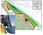
As part of the government’s Ocean Survey 20/20 programme, NIWA contributed in October and November to the largest coastal survey of its kind to take place in New Zealand waters. Previous Ocean Survey 20/20 projects have looked at deepsea environments; now attention has turned to shallow coastal waters. This project focuses specifically on the Bay of Islands, and an area from North Cape to Poor Knights Islands was surveyed to a depth of 200 metres, giving a total survey area of 3530 square kilometres.
The survey is coordinated by Land Information New Zealand (LINZ), with Ministry of Fisheries, Department of Conservation, and Northland Regional Council providing scientific advice and support.
“The main focus of this project is to map the Bay of Islands’ marine biodiversity as well as its seabed habitats,” says LINZ General Manager Policy, Kevin Kelly. “We also intend to collect sediment and water quality data and possibly information on the geology under the seabed. The data we collect during the project can then be used by government agencies, regional and district councils, and local groups to develop and manage the Bay of Islands coastal resources in a more effective and sustainable way.”
NIWA’s role in the initial phase was to map the physical marine environment. Two of our vessels are fitted with multibeam acousticsystems that use sound waves to measure depths and to characterise the seabed. RV Tangaroa is used for deep water (50–200 metres) and RV Pelorus for shallower water (10–50 metres). A third craft, Bella Vita, is fitted with sidescan sonar for surveying depths of 2–10 metres. Shallower areas were covered by high-resolution aerial photography at very low tide.
Hydrographic surveyor Anne-Laure Verdier said the NIWA survey team was grateful to the people of Northland for their support andinterest in the project, which will greatly improve the understanding of marine biodiversity and habitats and help with future decisionmaking. “We’re also pleased to have been able to give back to the community. The survey launch Pelorus has been able to assist in three marine rescues since arriving in the area,” Anne-Laure said. In addition to their intended work, NIWA staff assisted a grounded yacht, towed a small catamaran which had been blown off its mooring, and responded to another Mayday.
For further information, contact:Neville Ching, 0-4-386 0597, [email protected] or visit the LINZ website: www.linz.govt.nz/hydro/projects-programmes/ocean-survey-2020
