Our Land and Water is the science challenge that addresses conflicts and tradeoffs between the needs for agricultural productivity and environmental health and protection. NIWA plays a big role in Our Land and Water, particularly in biophysical science and tool development.
Our Land and Water is the National Science Challenge concerned with protecting New Zealand’s freshwaters, coastal waters and soils while ensuring sustainable productivity in the primary sector. The Māori title of the challenge is Toitū te Whenua, Toiora te Wai (let the permanence of land remain intact; let water abound). Our Land and Water currently consists of seven ‘cornerstone’ programmes, and eight supporting projects. The cornerstone programmes cover a wide range of issues in primary land use and soil and water management.
NIWA leads three of the cornerstone programmes in Our Land and Water, Land Use Suitability, Sources and Flows, and Interoperable Modelling Systems. The aims of these programmes are described below. In addition, a substantial proportion of work funded by the Strategic Science Investment Fund in NIWA’s Freshwater and Estuaries Centre is aligned directly with Our Land and Water, and an even larger proportion contributes to the Our Land and Water mission.
Sources & Flows
The Sources & Flows programme is led by MS Srinivasan and Diana Selbie (AgResearch), with a team from AgResearch, NIWA, Landcare, Lincoln Agritech, ESR and Tipa and Associates Limited.
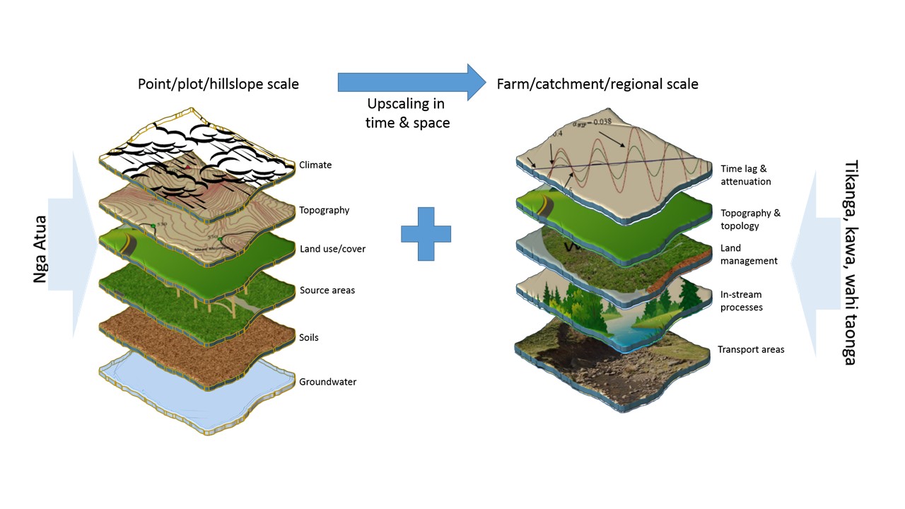
The overarching aim of the programme is to understand the fate, transport and attenuation processes of key contaminants - nitrogen, phosphorus, sediment and microbes - within catchments and from catchments to receiving waters.
In the first phase of the programme, we are developing a conceptual framework that describes the hydrological processes and cultural considerations linked to contaminant transport processes. Several direct and indirect methods to measure and infer contaminant source and transport processes shall be examined. A national-wide diagnostic modelling exercise is to be carried out using the CLUES model to identify catchments where contaminant source-delivery-attenuation processes are critical to land and water quality.
Land use suitability
The Land Use Suitability programme is led by Scott Larned, with a team from LandCare Research, University of Otago, Land Water People, AgResearch, Plant and Food Research, Streamlined Environmental, NIWA and Tipa & Associates.
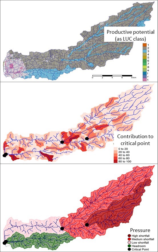
The programme aims to help stakeholders in land use and management evaluate different approaches for sustainable production within the constraints posed by environmental objectives (also expressed as ‘managing within limits’). Some of the first environmental objectives we are addressing are freshwater ones associated with the National Policy Statement for Freshwater Management.
In the first phase of the programme, we are developing tools to assess land parcels within catchments in terms of the productive potential of land, the risk of contaminant loss from land, and the risk that contaminant losses will have adverse impacts in receiving environments downstream. The second phase will focus on evaluating options for managing within limits when environmental objectives are not being met. These options range from shifts in land use practices, to mitigation systems, to interventions in the environments affected by land use pressures.
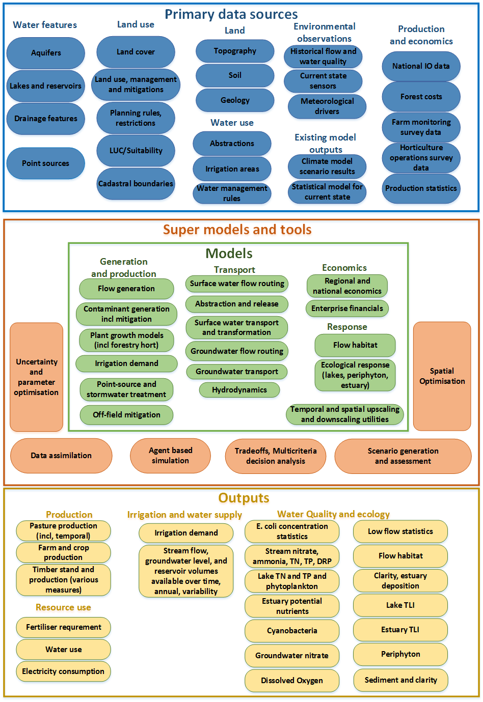
Interoperable Modelling Systems
The Interoperable Modelling Systems programme is led by Sandy Elliott, with a team from a range of science providers. The aim of the programme is to develop an interoperable modelling system suitable for integrated spatial assessment of the economic, production and environmental implications of land use and land use change, operating at farm through to catchment scales. The anticipated uses of the system include assessment and accounting of production potential and water quality contaminant dynamics. The programme is based on the idea that the availability of better, more trusted, and targeted modelling tools within an interoperable modelling framework will result in more effective use of integrated modelling for improved production and environmental management.