A wet and warm autumn for much of New Zealand
|
Temperature |
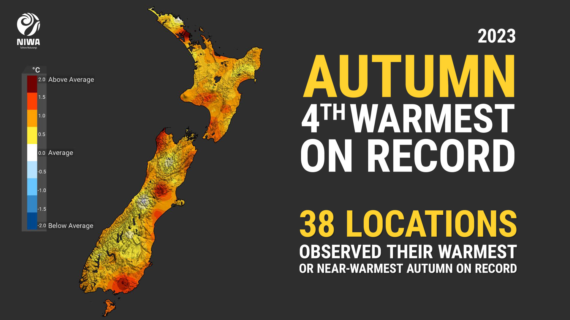
Autumn temperatures were above average (+0.51°C to +1.20°C of average) or well above average (>1.20°C of average) across nearly all of Aotearoa New Zealand. Small pockets of near average temperatures (±0.50°C of average) were observed near Cape Reinga, eastern Northland, and far interior Canterbury and Otago. No areas experienced below average autumn temperatures. |
|
Rainfall |
It was a wet season for large swathes of New Zealand, with above normal (120-149% of normal) or well above normal (>149% of normal) rainfall observed in much of Northland, Auckland, parts of Bay of Plenty and the Central Plateau, Taranaki, coastal Manawatū-Whanganui, parts of Wellington-Wairarapa, much of Marlborough, Nelson, Tasman, the West Coast, central Canterbury, Otago, and interior Southland. Pockets of below normal rainfall (50-79% of normal) occurred in eastern Northland, northern Waikato, coastal Gisborne and Hawke’s Bay, and coastal South Canterbury. Elsewhere, autumn rainfall was near normal (80-119% of normal). |
|
Soil moisture |
At the end of autumn, soil moisture levels were near normal or above normal across a large majority of New Zealand. However, below normal soil moisture was observed in coastal South Canterbury. |
Overview
Autumn 2023 was characterised by higher than normal mean sea level pressure (MSLP) east of Aotearoa New Zealand and lower than normal MSLP over New Zealand and the Tasman Sea. This generally resulted in more northeasterly winds than normal, bringing moist air from the tropics and sub-tropics across New Zealand, resulting in periods of wet and warm weather.
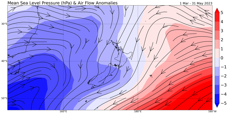
The season saw a transition from a long-term La Niña pattern to an ENSO-neutral state, allowing for some variability in the monthly air flow patterns. While March saw more westerly winds than normal, both April and May returned to northerly-quarter air flow anomalies, more typical of a La Niña regime. Periodic pulses of the Madden-Julian Oscillation (MJO) traversing the equatorial Pacific Ocean also enabled New Zealand to remain in a wetter La Niña-like pattern, especially during May.
The season saw monthly variations in temperature and rainfall as well. While March featured near average temperatures overall, April was New Zealand’s 11th-warmest April on record, and May was New Zealand’s warmest May on record since 1909, with an incredible anomaly of 2.0°C above the long-term (1991-2020) average. May in particular pushed the season up to become the 4th-warmest autumn on record, surpassed only by 2022, 2016, and 1938.
An ongoing marine heatwave event contributed to the unusual warmth. For the west and east of the South Island, autumn sea surface temperatures (SSTs) were the 2nd-warmest on record since records began in 1981. For the north of the South Island, SSTs were the 3rd-warmest on record.
Similarly, both March and May were very wet for many regions of the country, while April tended drier than normal for many regions.
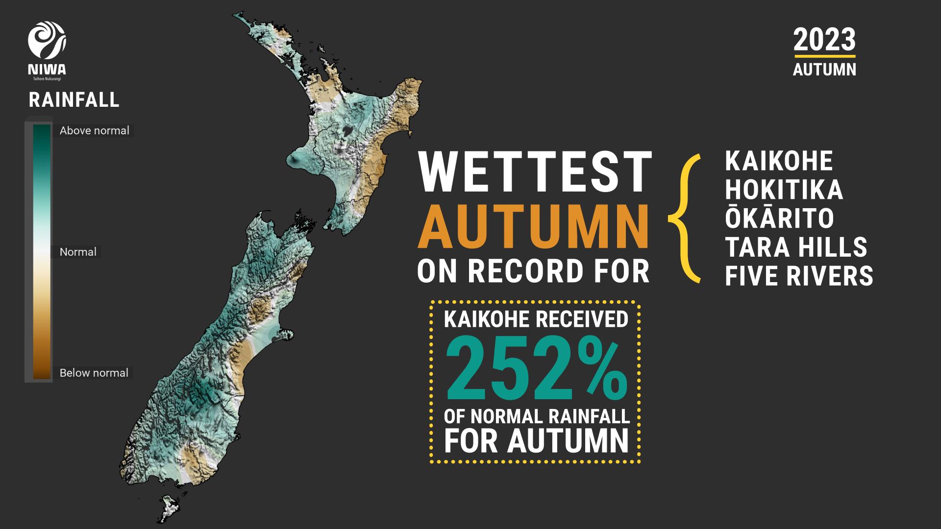
Overall, the most impactful event during the season was an atmospheric river originating in the tropics that brought heavy rain to large swathes of the country during approximately the first ten days of May. The atmospheric river varied in strength and location during this time, but nevertheless delivered periods of heavy rainfall and thunderstorms to much of the North Island and the western and northern South Island. During this time, parts of the North Island and South Island recorded 1-2 times their normal May rainfall, including Kaikohe receiving 372 mm or 237% of its May normal, Nelson at 167 mm or 194% of its May normal, Whangārei at 178 mm or 158% of its May normal, and Auckland 133 mm or 120% of its normal May rainfall (see the Highlights and extreme events section below for more details).
Despite the season’s strong wet and warm lean, there were a few hints at the colder months to come. On 21 March, snow fell to approximately 800 metres above sea level across parts of the lower South Island. And On 11 May, a powerful cold front brought the coldest day since October 2022 for large parts of the South Island and snow down to around 400 metres for parts of Southland, Queenstown-Lakes District, and the Mackenzie Basin.
Further highlights for autumn 2023:
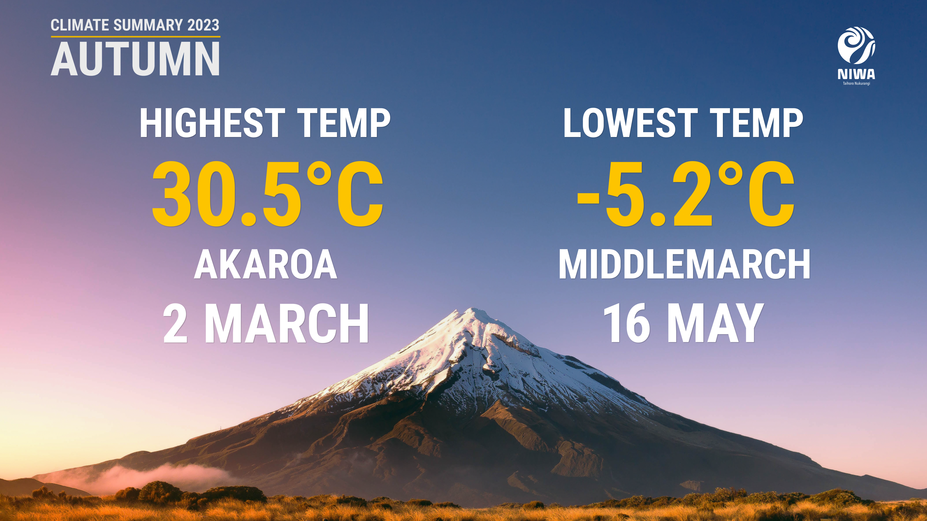
- The highest temperature was 30.5°C, observed at Akaroa on 2 March.
- The lowest temperature was -5.2°C, observed at Middlemarch on 16 May.
- The highest 1-day rainfall was 241 mm, recorded at Milford Sound on 2 May.
- The highest wind gust was 193 km/h, observed at Cape Turnagain on 26 April.
- Of the available, regularly reporting sunshine observation sites, the sunniest four regions in 2023 so far are Taranaki (1101 hours), Central Otago (1100 hours), Mackenzie Country (1096 hours), and the West Coast (1060 hours).
- Of the six main centres in autumn 2023, Auckland was the warmest, Christchurch was the coolest, Tauranga was the wettest and sunniest, Dunedin was the driest, and Wellington was the least sunny.