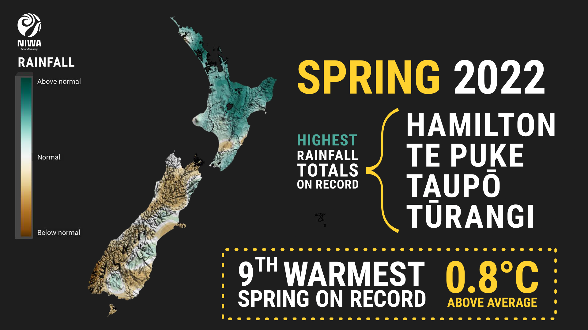
A wet & warm spring in the North Island; near normal South
|
Temperature |
Spring temperatures were generally above average (+0.51°C to +1.20°C of average) for a majority of the North Island, Nelson, parts of Tasman and Marlborough, far northern Canterbury, most of the West Coast, and Fiordland. Isolated pockets of well above average temperatures (>1.20°C of average) were observed in Northland and eastern Bay of Plenty. Near average temperatures (±0.50°C of average) occurred in western Waikato, coastal Gisborne, Wairarapa, along with most of Canterbury, Otago, and Southland. No areas experienced below average temperatures. |
|
Rainfall |
It was a very wet season in much of the North Island, with above normal (120-149% of normal) or well above normal (>149% of normal) rainfall observed in most regions, along with parts of central and southern Canterbury. Near normal rainfall (80-119% of normal) was observed in western Northland, parts of Manawatū-Whanganui and western Wellington, along with a majority of the South Island. Pockets of below normal rainfall (50-79% of normal) occurred in the interior upper South Island, Marlborough, Banks Peninsula, eastern Otago, and Southland. |
|
Soil moisture |
At the end of spring, soil moisture levels were above normal to well above normal across most of the North Island, northern Tasman, Marlborough Sounds, northern and central Canterbury, and parts of Southland. Soil moisture was near normal across most of the South Island. Slightly below normal soil moisture was observed in coastal Wairarapa and the Dunedin area. |
Overview
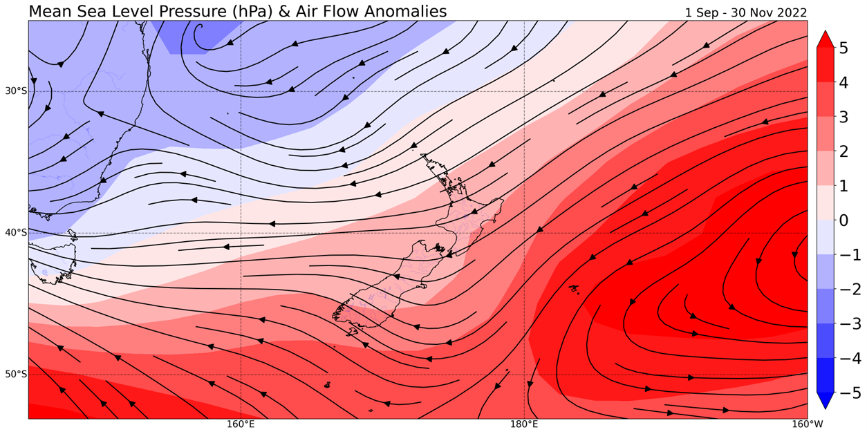
Spring 2022 was characterised by higher than normal pressure east of Aotearoa New Zealand and lower than normal pressure over eastern Australia and the Coral Sea. This generally resulted in more northeasterly winds than normal, bringing moist air from the tropics and sub-tropics across New Zealand, resulting in periods of wet and warm weather.
Despite this general pattern, notable winter-like cold snaps were experienced in the early parts of both September and October. Snow flurries were reported in central Dunedin on 5 September, with snow and ice causing treacherous conditions about the hill suburbs of the city on 6 September. Farther north, snow fell to sea level at Christchurch with light accumulations of snow reported in parts of the city. An even more impactful springtime snow event occurred on 5-6 October as a series of cold fronts passed across the South Island, delivering snowfall to sea level for widespread parts of Southland, Otago and Canterbury. The heaviest snowfalls were reported across inland and northern parts of Southland, where approximately 25-30 cm of snow was recorded down to elevations of approximately 300 m above sea level. Snow settled to near sea level in Wellington and low elevations in Manawatū-Whanganui, with widespread snowfall reported in Taranaki. (See the Highlights and extreme events section for more details.)
These early September and early October cold outbreaks saw numerous spring records and near-records set for both coldest daytime maximum temperature and coldest overnight minimum temperature.

After both September and October had near average nationwide temperature anomalies (based on NIWA’s seven-station temperature series which begins in 1909), November was New Zealand’s warmest November on record. With a temperature anomaly of 1.8˚C above average, November propelled spring 2022 into a top-10 warmest ranking. Contrary to the cold records and near-records observed in September and October, November saw a plethora of warm daytime maximum and overnight minimum records and near-records.
November was particularly wet and warm across the country as multiple climate-drivers were active, including La Niña, the Madden-Julian Oscillation (a tropical pulse of rain and cloud that was active in the region), and the negative phase of the Indian Ocean Dipole, marked by warmer than average seas in the tropical eastern Indian Ocean near Sumatra and cooler seas in the west near Africa. This acted as another moisture source for New Zealand, with water vapour streaming across Australia into the Tasman Sea and Coral Sea at times. In addition, marine heatwave conditions remained in place for much of New Zealand’s coastal waters, further enhancing the amount of water vapour available.
Note that due to data collection issues, there are fewer stations than normal in this summary. This does not affect the results of the seven station series.
Further highlights for spring 2022:
- The highest temperature was 30.2°C, observed at Hanmer Forest on 15 November.
- The lowest temperature was -9.6°C, observed at Mount Cook Airport on 6 September.
- The highest 1-day rainfall was 168 mm, recorded at Lake Moeraki on 1 September.
- The highest wind gust was 176 km/h, observed at Cape Turnagain on 4 September.
- Of the available, regularly reporting sunshine observation sites, the sunniest four regions in 2022 so far are Taranaki (2388 hours), Bay of Plenty (2335 hours), Wider Nelson (2325 hours), and the interior of Canterbury (2251 hours).
- Of the six main centres in spring 2022, Auckland was the warmest, Dunedin was the coolest and driest, Tauranga was the wettest, Christchurch was the sunniest, and Hamilton was the least sunny.