New Zealand’s equal-second warmest autumn on record
|
Temperature |
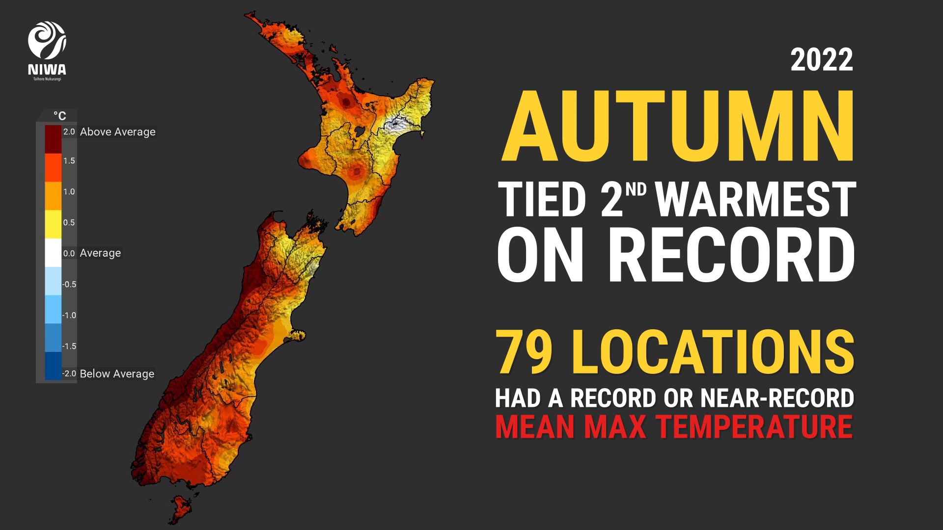
Autumn 2022 was the equal-2nd warmest autumn on record in Aotearoa New Zealand. Temperatures were well above average (>1.20°C above average) across the West Coast, Southland, Otago and the Canterbury high country, as well as large parts of Auckland, Northland, northern Waikato and eastern Wellington. Temperatures were otherwise above average (+0.51°C to +1.20°C of average) elsewhere, except for small pockets of the east coast of both the North and South Islands where temperatures were near average (±0.50°C of average). |
|
Rainfall |
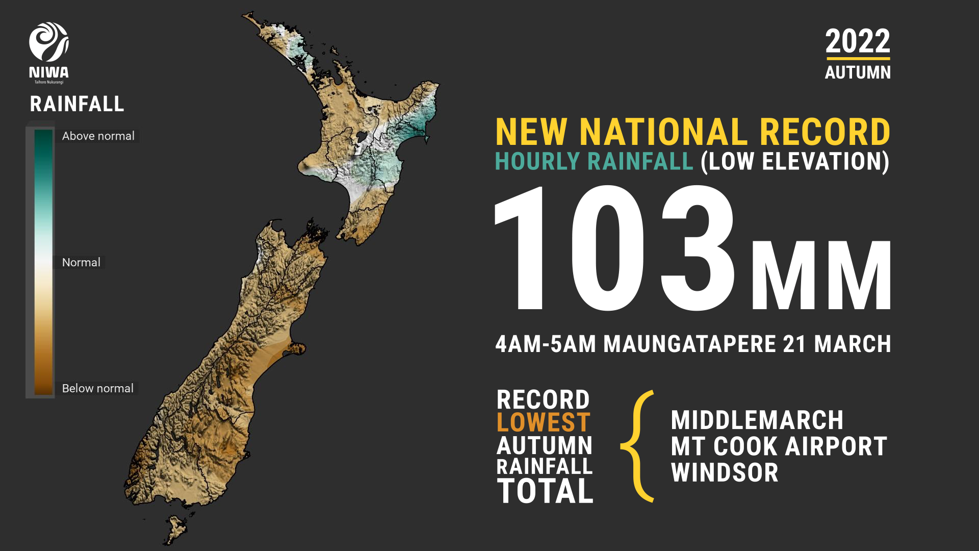
Autumn rainfall was above normal (120-149% of normal) for pockets of Hawke’s Bay, Gisborne and Northland, with a small area of well above normal (>149% of normal) around eastern Wairoa. Below normal rainfall (50-79% of normal) was observed in parts of Far North, Kaipara, Auckland, Waikato, South Wairarapa, and parts of Canterbury and Otago, while well below normal rainfall (<50% of normal) was observed about Waitaki, Dunedin, Banks Peninsula and Selwyn. |
|
Soil moisture |
At the end of May, drier than normal soils were prominent for Otago, eastern and inland Canterbury about and south of Christchurch, southern Wairarapa, northern Waikato, Auckland, and eastern and northern parts of Northland. Soils were wetter than normal for the parts of Manawatū-Whanganui, Hawke’s Bay and coastal Gisborne. |
Overview
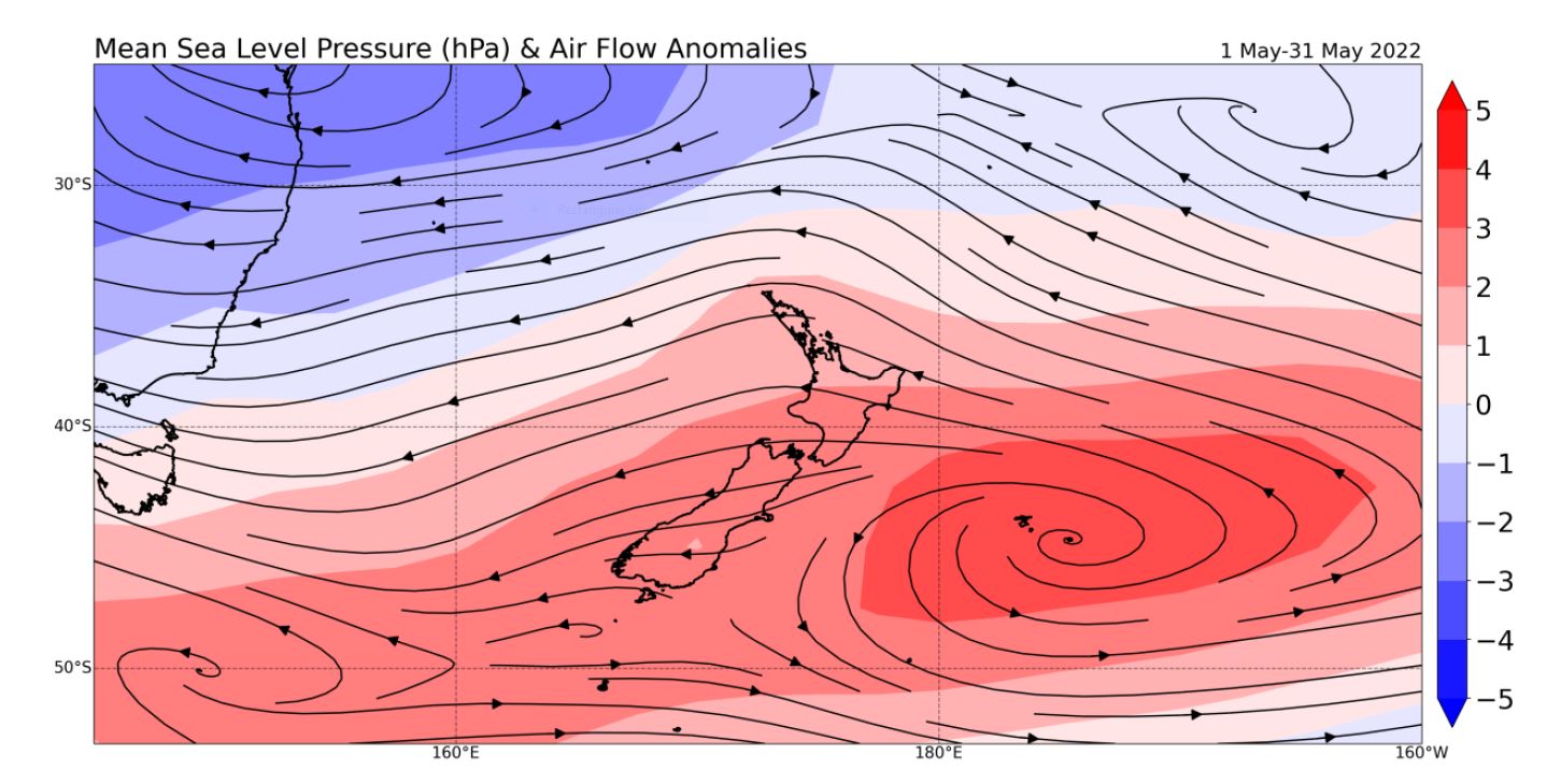
Autumn 2022 was characterised by higher-than-normal air pressure over much of Aotearoa New Zealand and east of the country, typical of La Niña. This resulted in an easterly flow anomaly.
The Southern Annual Mode (SAM), a proxy for the strength and location of the westerly winds that bring colder temperatures and wetter conditions to parts of New Zealand, was in its positive phase 66% of the time in autumn. This contributed to a lack of cold frontal systems, and when combined with easterly flow anomalies, caused several dry and sunny spells in the West Coast, Southland, Otago and Canterbury high country. This was also the case for Waikato and Auckland where soil moisture levels were well below normal during May.
The nationwide average temperature for autumn 2022 was 14.7°C (1.4°C above the 1981-2010 average from NIWA’s seven station temperature series which begins in 1909), making autumn 2022 the equal-second warmest autumn on record.
The warmth on land was matched by the warmth at sea. Coastal waters around New Zealand were also exceptionally warm, continuing a prolonged marine heatwave (MHW) event. For the autumn season as a whole, sea surface temperatures (SSTs) were the warmest on record in the west of the South Island (2.6˚C above average), north of the South Island (1.8˚C above average), east of the South Island (1.7˚C above average), and second-warmest on record in the north and west of the North Island (1.5˚C above average) since autumn 1982. The exceptionally warm autumn that the country experienced can be attributed to the record and near-record warm SSTs, higher-than-normal pressure, a persistently positive SAM, and global climate change.
Rainfall was more patchy across the season, with bursts of heavy rain events interspaced by long dry spells. In March, heavy rain hit parts of Northland, Auckland and Gisborne in a series of thunderstorms. A new national hourly rainfall record for a low-elevation station (less than 500 above sea level) was set at Maungatapere near Whangārei, where 103 mm of rain was recorded from 4 a.m. – 5 a.m. on March 21. In contrast to this, meteorological drought that had developed in late summer in Southland worsened in March, before easing at the beginning of May. At the end of the season, a series of low pressures systems battered New Zealand, leading thunderstorms, a likely tornado in Levin, as well crop damaging hail. See the Highlights and extreme events section for more details.
Further highlights for autumn 2022:
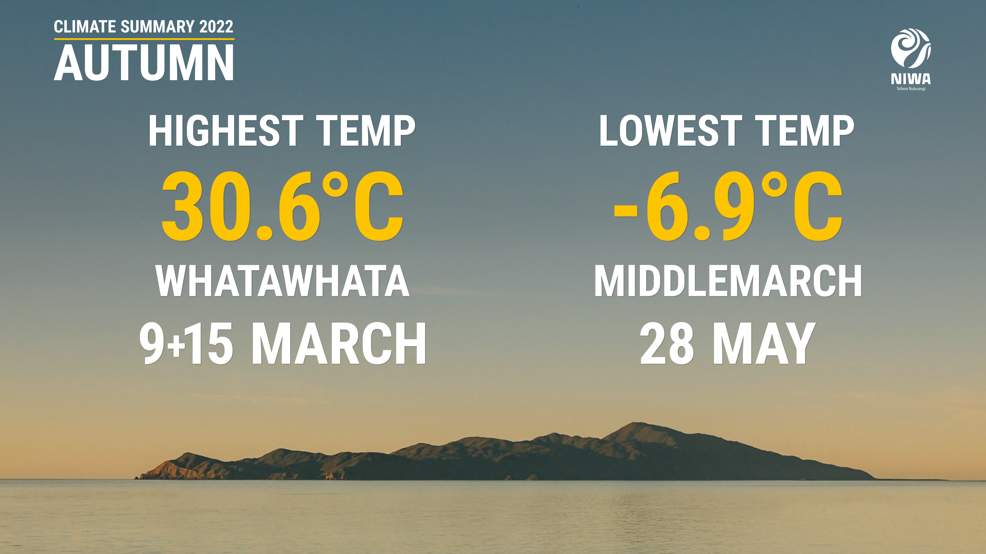
- The highest temperature was 30.6°C, observed at Whatawhata on 9 and 15 March.
- The highest 1-day rainfall was 226 mm, recorded at Milford Sound on 20 April.
- The highest wind gust was 193 km/h, observed at Cape Foulwind on 20 May.
- Of the six main centres in autumn 2022, Auckland was the warmest, Christchurch was the coolest, Hamilton was the sunniest, Wellington was the least sunny, Tauranga was the wettest, and Dunedin was the driest.
- The lowest temperature was -6.9°C, observed at Middlemarch on 28 May.
- Of thE available, regularly reporting sunshine observation sites, the sunniest four locations in 2022 so far are Taranaki (1290 hours), Bay of Plenty (1203 hours), Greater Nelson (1194 hours) and Kāpiti Coast (1170 hours).
Download
- Climate Summary Autumn 2022 (PDF 835.7 KB)