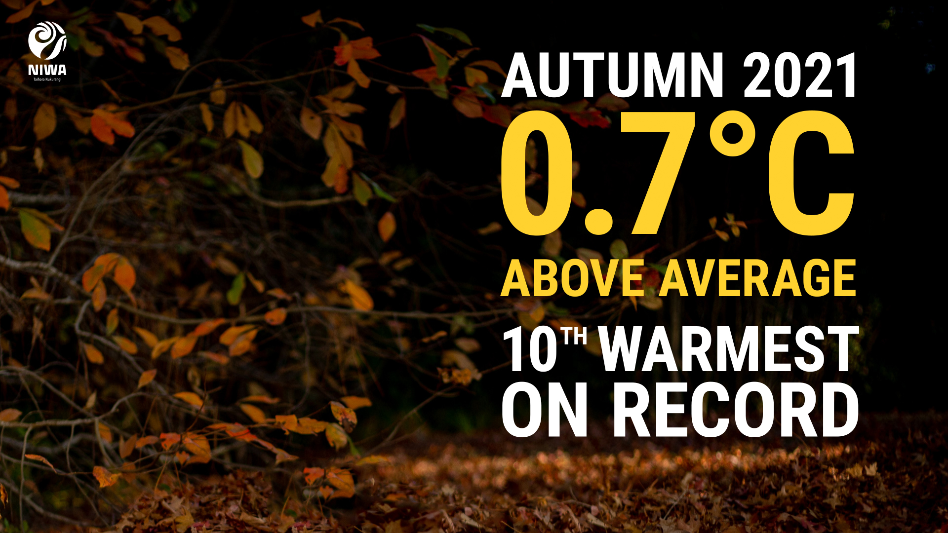
A warm autumn with bursts of heavy rainfall
|
Temperature |
Autumn 2021 was the 10th-warmest autumn in 112 years of records. Temperatures were above average (+0.51°C to +1.20°C of average) for most of Aotearoa New Zealand. Pockets of well above average temperatures (>1.20°C above average) were recorded in eastern Canterbury. Near average (±0.50°C of average) temperatures were recorded in most of Northland, parts of Auckland, parts of Waikato, parts of Bay of Plenty, most of Marlborough and Tasman, and scattered portions of Southland, Otago and West Coast. No areas experienced below average temperatures. |
|
Rainfall |
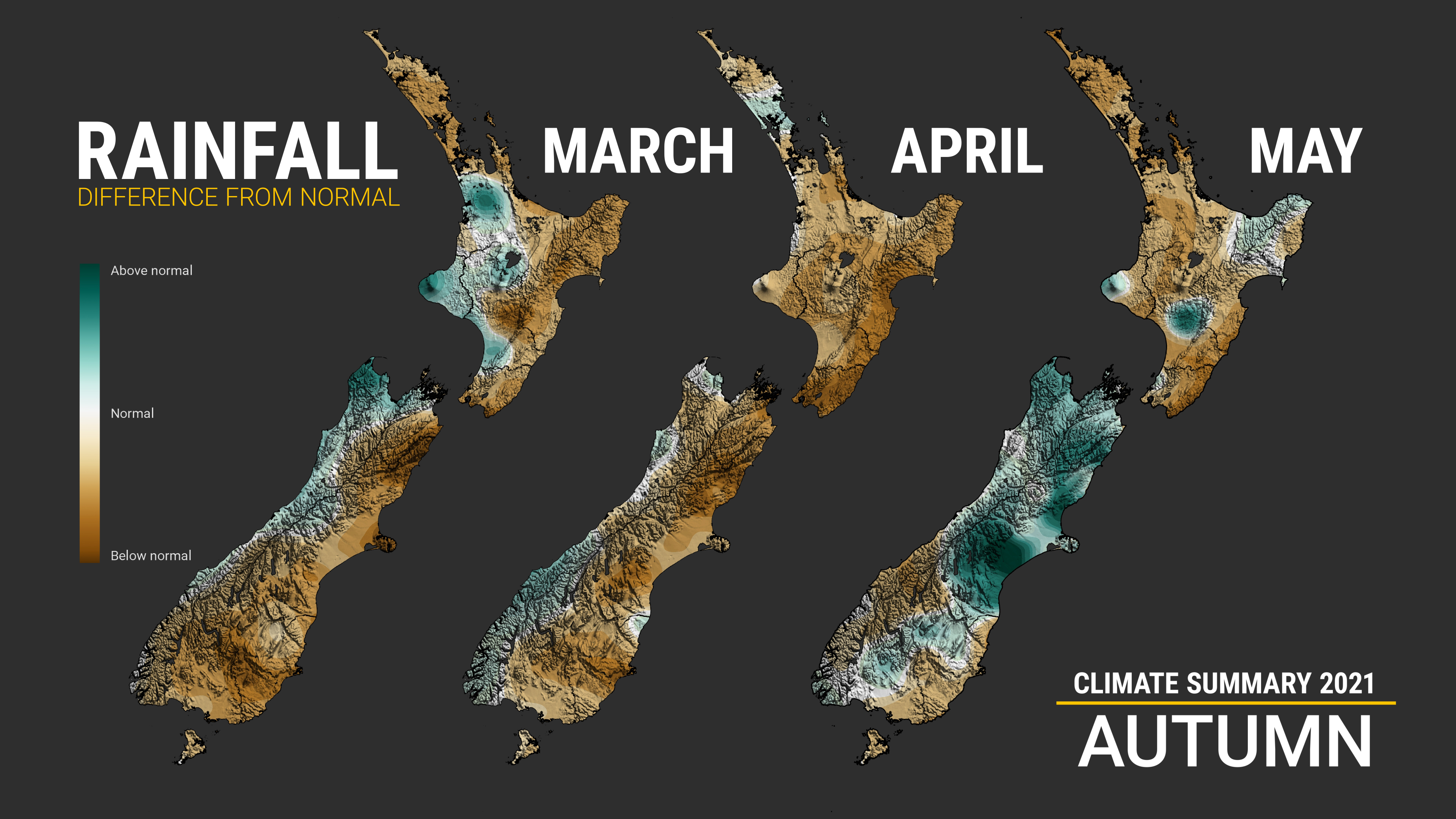
Autumn rainfall was below normal (50-79% of normal) across Northland, Auckland, parts of Waikato, parts of Manawatū-Whanganui, Gisborne, Hawke’s Bay, Wairarapa, eastern Southland and most of Otago. Above normal rainfall (120-149% of normal) was observed in parts of Taranaki, northern Tasman, Nelson, northern Marlborough, and parts of eastern Canterbury. Pockets of well above normal rainfall (>149% of normal) was observed around Ashburton. Most of the total autumn rainfall that was recorded in the Canterbury region fell in the last two-to-three days of the season. Near normal rainfall (80-119% of normal) was observed elsewhere. |
|
Soil moisture |
At the end of autumn, soil moisture levels were drier than normal for northern Northland, Auckland, parts of Waikato, southern Hawke’s Bay, the Tararua district, the Wairarapa, much of the Otago and southern parts of the Canterbury. Soil moisture levels were wetter than normal spanning from the Nelson/Marlborough region through to much of eastern Canterbury. |
Overview
Autumn 2021 was characterised by long dry spells and warmth, interspaced by bursts of heavy rainfall. This was because La Niña began its transition to ENSO-neutral in March and the dominant climate driver became the Madden-Julian Oscillation (an eastward moving “pulse” of cloud and rain in the tropics). The MJO lingered over the western Indian Ocean, leading to higher than normal pressures over Aotearoa New Zealand. As a result, much of Aotearoa experienced warm days, but chilly overnight temperatures. However, on the occasions when the MJO quickly pulsed across the Pacific, this led to several notable rain and storm outbreaks, including the Canterbury flood event at the end of May.
Temperature
The nationwide average temperature for autumn 2021 was 14.0°C (0.7°C above the 1981-2010 average from NIWA’s seven station temperature series which begins in 1909), making it the 10th-warmest autumn on record. No areas of New Zealand experienced below average temperatures during autumn. Autumn 2021 temperatures were above average (+0.51°C to +1.20°C of average) for most of New Zealand. Pockets of well above average (>1.20°C above average) were recorded in eastern Canterbury while near average (±0.50°C of average) temperatures were recorded in most of Northland, parts of Auckland, Waikato and Bay of Plenty, most of Marlborough and Tasman, and scattered portions of Southland, Otago and West Coast. Although there were some cool spells, summer-like heat lingered well into autumn. Notably, parts of Canterbury and Hawke’s Bay observed several days of temperatures above 30°C during March, and notably a 30.8˚C day in Timaru on 4 April. This warmth was still felt well into May, where 29 locations observed record or near-record high daily maximum May temperatures during the month.

Rainfall
Autumn rainfall was below normal (50-79% of normal) across parts of Waikato as well as most northern and eastern North Island locations, including Northland, Auckland, parts of Manawatū-Whanganui, Gisborne, Hawke’s Bay, and the Wairarapa. In the South Island, below normal rainfall was also observed in eastern Southland and most of the Otago region. Above normal autumn rainfall (120-149% of normal) was observed in parts of Taranaki, northern Tasman, Nelson, northern Marlborough, and parts of eastern Canterbury. Pockets of well above normal rainfall (>149% of normal) was observed in eastern Canterbury. Near normal (80-119% of normal) was observed elsewhere. For most of the season, there was a clear east-west divide of rainfall, with fronts bringing rain to western areas but eastern areas missing out. However, bursts of sub-tropical and tropical moisture transported over New Zealand ahead of low pressure systems led to significant rainfall in some areas. Of most note was the Canterbury rainfall event which occurred in the final three days of autumn. Prior to this event, it had been a very dry season, with most of the region tracking towards less than half of its normal rainfall for autumn.
Further highlights for autumn 2021:
- The highest temperature was 31.9°C, observed at Waiau on 14 March.
- The lowest temperature was -10.8°C, observed at Tara Hills on 27 May
- The highest 1-day rainfall was 209 mm, recorded at Milford Sound on 8 May.
- The highest wind gust was 178 km/h, observed at South West Cape on 4 April.
- Of the six main centres Auckland was the warmest, Dunedin was the coolest and driest, Hamilton was the wettest, Christchurch was the sunniest, and Hamilton was the least sunny.
Download
- Climate Summary Autumn 2021 (PDF 433.64 KB)