Climate change will test the infrastructure of the future. We need to start planning now, finds Harriet Palmer, for higher tides and heavier downpours.
On 23 January, 2011, the moon was only three days past full, and had just passed the earth at the closest point of its monthly orbit. Few would have noticed, until the Waitemata Harbour inundated the Auckland waterfront.
King tides happen several times a year, but this one, swelled by a low-pressure system over Northland, took on a special energy. Every hectopascal below average air pressure can raise sea level by a centimetre. As the system bore down on Auckland, the phenomenon, abetted by high winds, had already lifted the harbour half a metre higher than the predicted tide.
Around noon, a 4.13m storm tide washed over parts of downtown, some eastern suburbs, and Herald Island, near Hobsonville, then flooded eastbound lanes on the northwestern motorway. Storm waves crashed over seawalls and beach boulevards, swamping shops, homes and roads. Stormwater systems, choked by sea water, backed up.
You have to go back to March 1936 to find the previous highest storm tide – 3.99m. Some people said climate change had arrived; others simply blamed the freakish conspiracy of weather and moon, but the inundation was compounded by one cold, hard fact: Auckland sea levels have risen by 17cm since 1900.
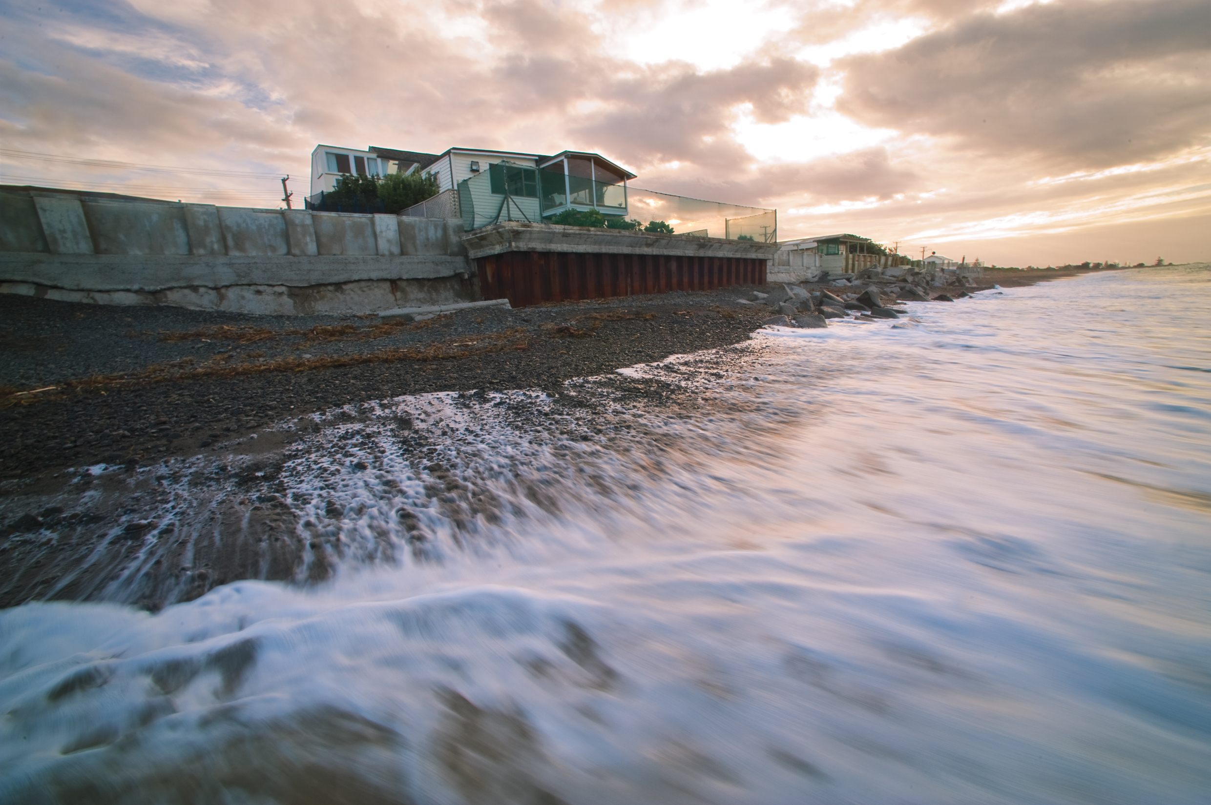
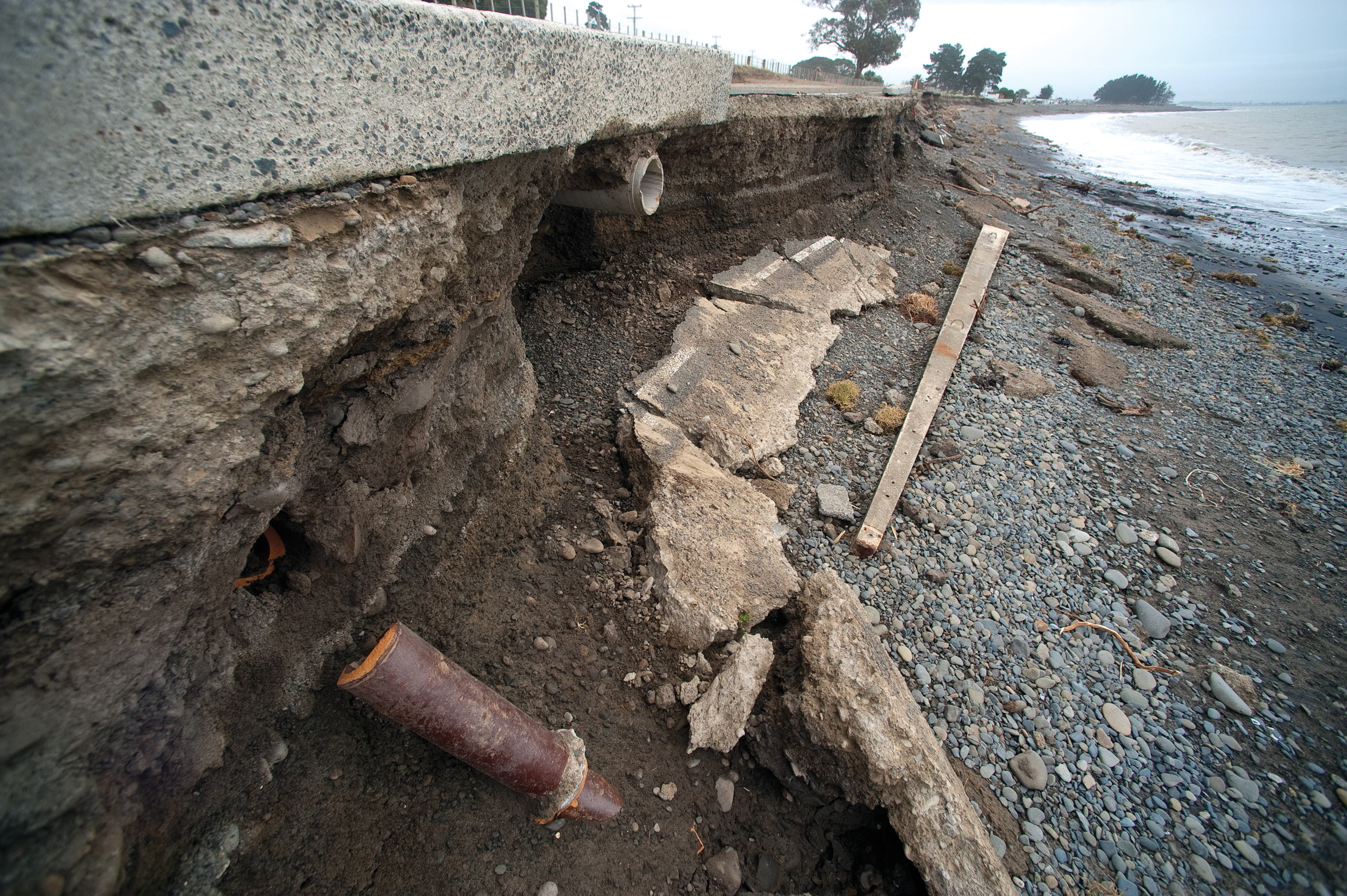
Much of New Zealand's urban coastline was built in the 19th century, when people and products got around by ship, and nobody had any inkling that their descendants would burn fossil fuels with such rapacity as to warm the very air. The seawalls built by the city fathers are starting to fail their great-grandchildren.
The Royal Society of New Zealand points out that many of us now live in the wrong place. In a 2010 Emerging Issues paper, it warned: "Twelve of New Zealand's fifteen largest towns and cities are coastal. They are already exposed to coastal hazards from current climate variability and weather events: coastal erosion, flooding from storm surges, waves and swell, king tides, extreme rainfall and saltwater intrusion into groundwater. Sea-level rise will compound these hazards, both in terms of frequency and intensity".
It falls mostly to territorial authorities to deal with all that. For now, they're working to the Ministry for the Environment's 2008 guidance manual, Coastal Hazards & Climate Change.
NIWA Principal Scientist Rob Bell helped write that guide. "We adopted a new, risk-based approach to help users decide which future sea-level rise to work with," he says, "but it's taken a while for councils to adapt to that more flexible strategy". He says practitioners crave a definitive single number – the precise amount of sea-level rise they should be planning or designing for – but they won't get one from Bell. "Due to the uncertainty around the likely rate of sea-level change, there's a reasonably wide range of increases one could look at," he says.
That range runs from a half-metre rise by the 2090s, to at least 0.8m or more, so it's important to weigh up the potential risk to each area or asset from each sea-level scenario.
"Consider how flexible it will be to adapt or retrofit that asset in the future, before deciding on an appropriate sea level to accommodate.
"Let's say you're building a toilet block on an esplanade seafront," he offers. "In that case, sea-level rise of half a metre is fine – the consequences of it being engulfed by waves are minor. But if you want to develop a coastal subdivision, or a thermal power plant, then you need a much higher benchmark. Applying a one-size-fits-all number to every activity, irrespective of risk, is potentially more costly".
So Bell advocates different numbers for different environments. For coastal greenfield projects – ventures or subdivisions built from scratch on largely undeveloped land – he cites top-end figures of 1.5m to 2m or more, "because you know that sea-level rise is going to continue for several centuries. There's no point in building something permanent, then having to uproot it and retreat inland in 100-plus years' time. You've got to face those levels eventually, so they should be factored in from the outset".
Existing development is different: "Auckland, Wellington and Nelson are classic examples of coastal urban centres – they're locked into a coastal squeeze around low-lying shores. Using top-of-the-range projections on such extensive development is just going to create a lot of angst. Say somebody applies to build a garage on to their home: you deal with that at a small, localised scale, but you do it within the context of a bigger, more strategic, long-term community plan to adapt to climate change in stages".
Most projections for sea-level rise are only available out to 2100. The updated New Zealand Coastal Policy Statement instructs councils to plan for coastal hazards and climate change effects out to at least the next 100 years. That means councils should now be looking out to 2115, says Bell, which means contemplating around a metre of higher tide.
Bell says sea-level rise – whatever the number – will be fairly uniform around the country, but there's room for discretion when it comes to dealing with it. He encourages planners and engineers to examine each case on its own merits – weigh up the specific risk – and tailor their response to the infrastructure, or assets, or environment at stake.
Some cases are better served by adaptive management, which lets decision-makers and their communities come up with a strategic plan, then decide how and when they stage it. By keeping an eye on sea levels, they can implement each pre-determined stage as those levels approach – rather than try to second-guess what the sea level will be in 2115.
"That could mean staged measures," says Bell, "such as nourishing beaches with sand, or shifting a road inland when sea levels reach a certain height. It could mean jacking buildings up, or eventually moving them as part of a managed retreat, but you can always accelerate an adaptive plan, or slow it down in response to sea-level trends". Seafront property owners at Haumoana, on the Hawke's Bay cape coast, routinely flee their homes in the face of waves that break a little closer every year.
There are more curve balls coming out of climate change than just sea-level rise. Planners and engineers must now design infrastructure and systems capable of coping with more dramatic weather: more frequent, heavier rains will sorely test ageing stormwater systems, and trigger more slips, and higher temperatures will shrink the very ground, as they did in Whangarei during the 2009–10 drought, shifting piles and cracking walls and roads. Water supplies will be found wanting.
Yet local authorities face those challenges in the absence of any policy guidance, says Frances Sullivan, a Senior Policy Analyst at Local Government New Zealand.
"Local authorities are really struggling around decisions to try to manage risk. We need a National Environmental Standard for sea-level rise, and a National Policy Statement to cover flooding. We keep trying, but so far have had no success at all in our efforts to integrate risk management into the RMA process".
Sullivan can't understand why policy measures so obviously in the national interest are not treated as such. "It's very frustrating," she says. "A local authority makes a sensible, precautionary decision that conflicts with a developer's plans, and then ends up fighting the developer in the Environment Court – it happens time after time, and it's very expensive".
Not as costly as cleaning up after natural disasters, though, so most major authorities are pressing ahead regardless. Wellington, Christchurch and Dunedin city councils are devising or updating climate change strategies which try to envisage a warming world, and offer ways to mitigate what impacts we can, and learn to live with those we can't.
Wellington – let's talk
Sea-level rise is high on Chris Cameron's mind, too. Much of Wellington's CBD, and major road and rail routes, are built on old seabed that was heaved upwards into terra not-sofirma by the 1855 earthquake.
As Wellington City Council's Principal Climate Change Adviser, Cameron is part of a team modelling a range of sea-level scenarios. They've already abandoned a half-metre projection – their scenarios begin with tides a metre higher by 2100. That, according to WCC simulations, would see much of the waterfront under water. Another half-metre rise, and the waterfront, the railway station, and most of Wellington's 'Golden Mile' would be committed back to the sea.
The city faces some difficult choices, says Cameron. He wants to start a conversation with Wellingtonians right away, to help them grasp the full magnitude of his scenarios through 3D computer simulations of 'their place'. "What I need most is some way to value an area in terms of everything it has – its multiple cultural, social, environmental and economic values. How can I compare the value of, say, Oriental Bay, with Centreport, or with a residential suburb?"
He's certain of one thing, though; poor planning will leave the city trying to engineer its way out of each new crisis as it arises – a costly option unlikely to preserve those multiple values.
Dunedin – cheques and balances
Further south, a 2010 study, Climate Change Impacts on Dunedin, found that Dunedin's shoreline roads and railways, and the coastal hamlet of Aramoana near the Otago harbour entrance, are vulnerable to rising tides. More critical, though, is densely-packed, low-lying South Dunedin, which lies squarely in the path of advancing seas. Storms have already seriously eroded the sand dunes in places, and the study, penned by Blair Fitzharris, Professor Emeritus at the University of Otago, found that shoring up those dunes might only delay retreat or eventual evacuation.
"Some coastal land and infrastructure may have to be abandoned," he wrote, "in a planned retreat inland and to higher ground. These communities are unlikely to be able to afford the cost of building and maintaining protection structures". Storms have already undermined a sea wall built at St Clair, along with any faith that hard engineering can long resist the elements.
Not all sea water comes in over the top; some invades underground aquifers, forcing back storm and waste waters and raising water tables to bedevil infrastructure and services. Climate change projections foretell heavier rains, and pumping stations, such as the one in Dunedin South at Musselburgh, will struggle against the power and weight of an incoming sea, as will rivers and streams. We can expect to see more suburbs flooded when high tides coincide with storm surges.
Dunedin Airport, on the lower Taieri Plains, was heavily flooded in 1980, and Airport Operations Manager, Richard Roberts, says it's only a matter of time before it happens again. He's seen three more close calls during his 12 years at the airport, most recently in May 2010, after five days of rain. Water was lapping at the top of the stopbanks, and contractors were lined up to start sandbagging.
"The airport itself can do nothing to stop this area flooding," explains Roberts. "The Regional Council is responsible for maintaining stop banks and pumping stations; and the whole valley is artificially drained".
But past experience is driving present practice. "In 1980, the internal damage was very serious, and that's what delayed re-opening. So we've lifted everything up; all our main switchboards, all our IT – everything we need to run the airport – is on the first floor. And our standby generator is 1.2m off the floor in the car park. We've mitigated the risk".
Still, rising groundwater could fracture the runways, and Roberts's contingency plan is to drill hundreds of small holes in the tarmac to relieve the pressure.
Back-up in a box
But emergency, or stopgap, measures won't be enough, says Dr Andrew Tait. A principal scientist at NIWA in Wellington, he says that while many local authorities are thinking strategically about climate change, many lack science-based support to help them assess likely impacts, or devise a response. Accessing recent, relevant research can be difficult. For example, many local authorities have sophisticated water yield data and population projections, but lack future climate scenarios, quite apart from the expertise and resources to integrate them into their own regional data.
Tait means to fix that with a toolbox to help urban authorities deal with coastal inundation, storms, flooding and drought.
The toolbox offers information in four tiers: risk, hazards, cost-benefit analysis of possible action and integrating all these factors.
"It's all about helping urban planners and engineers work smarter," he says, "to show them what types of information and resources exist, and provide examples of how they can be used.
"So we're helping them develop processes for managing climate change impacts, and also helping them overcome barriers to implementing them". GNS Science, engineering consultants MWH, and the Building Research Association of New Zealand (BRANZ) have brought their own expertise to the project, and a number of urban councils have supplied priority models and case studies.
GNS scientists have developed landslide models for Wellington City Council based on future rainfall projections, and NIWA scientists worked with the old North Shore City Council to model future wastewater flows based on similar scenarios.
Time and tide
Rob Bell has been helping Auckland Council and Nelson City Council factor sea-level rise into their resource management plans. Now, more than ever, he says, councils need credible advice: "Five years ago, we had a fairly well-defined band of sea-level rise projections out to 2100, but since then, the polar ice sheets have come into the equation. That's added increasing uncertainty around the upper range.
"So we're giving sound, credible guidance on adaptive approaches, tailored to the types of environments and community assets people are trying to manage. We're also providing information on coastal hazards – wave overtopping, storm surge, coastal erosion – because all those things will be exacerbated by sea-level rise.
"The natural instinct is to defend ourselves from the sea," he says. "We've been doing that since the days of King Canute, but that instinct will grow stronger as sea levels rise".
Kilbirnie: in harm's way
Kilbirnie is a low-lying Wellington suburb. Its northern boundary is Evans Bay, and the main access road to Wellington airport and Miramar peninsula runs along this boundary. Its southern foreshore is Lyall Bay, a popular, expansive recreational beach. Wellington City Council (WCC) says the suburb, largely built on sand, has potential for more high-density residential development. However, much of it lies between just one and three metres above sea level.
WCC has simulated three sea-level rise scenarios and their effects on Kilbirnie. In the medium term, groundwater flooding is tipped as the greatest consequence of a onemetre rise, exacerbated by storms and heavy rain.
Scenario One: 0.5m sea-level rise, plus storm surge
A likelihood the Council considers: "Almost a given – there is a strong probability that sea level will rise by 0.5m by the end of the century".
With reasonable planning, the suburb should be able to cope. High rainfall will likely cause more flooding, with lower discharge capacity and increased saltwater intrusion into stormwater pipes. Planners and engineers will need to better understand how a rising water table will affect Kilbirnie's largely sandy foundation.
Scenario Two: 1m sea-level rise, plus storm surge
A less-likely scenario. Says WCC: "it is possible that sea level could rise by one metre by the end of the century, though this is not by any means certain. The probabilities of a one-metre rise will increase over a longer period – current science suggests that this could become a reality some time in the 22nd century".
Hard engineering solutions, such as raising roads and building more stormwater pumping stations will become increasingly likely.
Planning restrictions will be phased in to specify precautions such as minimum floor-level heights for new houses, and 'no build' zones.
Along beaches, artificial barriers like sea walls, or natural ones like restored and enhanced dunes, will be considered. Failing those, a plan for managed retreat will be developed.
Scenario Three: 2m sea level rise, plus storm surge
A top-end scenario, says WCC, "only for consideration of very long term expectations beyond the 23rd century (or if predictions increase significantly from current scientific understanding)".
Overtopping, inundation and wave damage to beachfront properties and roads are expected. Sea water will invade stormwater and wastewater systems, making Kilbirnie's streets difficult to drain. A combination of major engineering works and retreat would be needed, but wave action and storm surge would hamper engineering solutions. More stringent planning restrictions would be needed.