PDF of this article (892 KB)
Mark Morrison, Richard Taylor, Jarrod Walker, and Darren Parsons are spending a lot of time at the coast – above and below the water – to learn how people enjoy themselves, and at what cost to the environment.
As New Zealand’s population continues to grow, especially along the coast, pressures on the coastal environment are increasing. Along with commercial activities, such as residential development, fishing, dredging, and sand-mining, people also enjoy the many recreational activities that the oceans provide. These include extractive uses, such as gathering seafood by hand-picking, line-fishing, netting, and snorkelling or diving, and non-extractive uses, such as swimming, surfing, boating and kayaking, dolphin and whale-watching, and viewing wildlife and scenery (both above and below water). All of these activities depend on healthy and functioning marine ecosystems to produce the things we so value, be it seafood, visual or physical experiences, or spiritual connections. To understand this dependency, we are engaged in a FRST-funded research programme to quantify the interactions between human recreation in the marine environment and the healthy functioning of natural ecosystems. Our research focuses on two areas, one nonextractive and one extractive.
Ecotourism at the Poor Knights
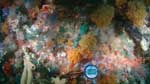
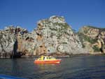
The Poor Knights Islands Marine Reserve enjoys international renown as an offshore island dive location. Warm subtropical currents bathe a spectacular underwater landscape of cliffs, archways, and caves, along with diverse communities of plants and animals. Thousands of divers visit annually, with numbers increasing.
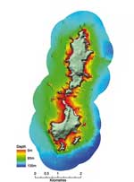
The interactions of such large numbers of divers with the reef systems they have come to experience and enjoy are poorly understood. They may include disturbance to seafloor communities through diver contact, changes in fish behaviour, and damage from boat anchors. As a baseline for our work, we initially habitat-mapped the Poor Knights Marine Reserve with high resolution multi-beam sonar. With the assistance of local charter operators, we then quantified gradients of diving intensity across the reef systems (ranging from effectively nil to more than 2000 dives per year), and have sampled the plant and animal communities across this gradient, using underwater video technologies, both diveroperated and remote. We’re assessing these data for evidence of impacts; later we’ll try to determine whether such impacts (if they exist) can be mitigated through management initiatives. Our overall goal is to protect both the valuable dive ecotourism industry, and the healthy coastal ecosystem on which the industry is built.
Snapper fishery in the inner Hauraki Gulf
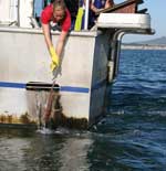
The city of Auckland is fortunate in having a world-class snapper fishery right on its doorstep. A substantial proportion of the overall recreational snapper catch comes from the inner Hauraki Gulf, with fishing ‘hotspots’ centred around such iconic locations as the Rangitoto and Motiuhe Channels and the Noises reef complex. These areas consistently produce good catches year after year, despite intensive fishing pressure which is increasing in line with Auckland’s population. The increasing harvests, along with broader habitat threats such as land-derived sedimentation, are thought to be putting this fishery resource under mounting pressure. As with the Poor Knights Islands, we have habitat-mapped some of the most intensively fished areas using multibeam sonar, and also with digital side-scan sonar, which can detect additional habitat features of soft sediment areas.
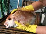
We suspect that such heavily fished areas are particularly attractive to fish, and as snapper are removed by fishing, other fish move in from surrounding areas to replace them. To test this hypothesis, we’ve tagged and released more than 5000 snapper, both in these heavily fished areas and in surrounding areas. We used individually numbered external dart tags, and rely on recreational and commercial fishers to return tags that they catch, along with associated details (see ‘What to do if you catch a tagged snapper’).
By the end of March, more than 100 tags had been returned. Data from these tags show both high residence – fish re-caught where they were tagged – and high mobility: tag returns range from Colville Channel down to Whale Island off Whakatane (Bay of Plenty), a straight-line distance of 230 km (as the fish swims).
In addition to the tagging work, we are using dropped underwater video (DUV) cameras, flown over the seafloor during the night, to count and measure sleeping snapper (see ‘Let sleeping fish lie’, W&A 12(2): 21). This technology lets us estimate how many snapper are present in each of the fishing areas, the length composition of the population, and how this changes seasonally. Preliminary data suggest snapper prefer complex seafloor structure, created by rocks, shells, sponges, and other invertebrates, which, in turn, is found in those more intensively fished areas.
Finally, we are using a combination of boat ramp interviews (recording the number and size of fish caught) and aerial over-flights (counting boats) to quantify the snapper being harvested from the different areas.
Combining these four data sources – habitat maps, tagging, underwater snapper counts, and recreational catch – we’re building up a good picture of both the natural population dynamics of snapper and how the recreational fishery interacts with snapper stocks, both spatially and temporally. Armed with this knowledge, we will be able to assess different potential management measures, with the aim of maintaining both this valuable coastal fishery and the marine ecosystem that ultimately underpins all fish production.
Measuring the cost of our watery pursuits
Polyculture is the concept of growing two or more complementary species together in a single sustainable system, as opposed to aquaculture, which involves the propagation and rearing of a single aquatic species. The goal of polyculture is to increase productivity of several species by efficient use of ecological resources. The productivity and waste of the primary polyculture species maintains the production of supplementary species. It’s not a new concept, having been practiced in China for more than 1000 years.
- Population growth is increasing pressure on coastal ecosystems.
- Researchers are studying the environmental effects of extractive and non-extractive recreation, including fishing and ecotourism.
- Quantifying the effects (for example, of recreational diving or fishing) will help formulate coastal management strategies.
What to do if you catch a tagged snapper
If you catch a tagged snapper, you can make a valuable contribution to this research by ringing the phone number on the tag and providing these important details:
- tag number
- date
- location
- depth
- fish length
- whether the fish was caught over reef or over soft sediment.
If the fish that you catch is undersized and therefore cannot be landed, simply measure its length, cut off the tag, and release the fish.
The phone number to ring (weekdays, 9 to 5) is 0–9–375 2050.
Further reading
Hartill, B.W., Cryer, M., Morrison, M.A. (2004). Estimates of biomass, sustainable yield and harvest: neither necessary nor sufficient for the management of amateur intertidal fisheries. Fisheries Research 71: 209–222.
Lewin, W.–C.; Arlinghaus, R.; Mehner, T. (2006). Documented and potential impacts of recreational fishing: insights for management and conservation. Reviews in Fisheries Science 14: 305–367.
McPhee, D.P.; Leadbitter, D.; Skilleter, G.A. (2006). Swallowing the bait: is recreational fishing in Australia ecologically sustainable? Pacific Conservation Biology 8: 40–51.
Morrison, M.; Carbines, G. (2004). Let sleeping fish lie. Water & Atmosphere 12(2): 21.
Morrison, M.; Carbines, G. (2006). Estimating the abundance and size structure of an estuarine population of the sparid Pagrus auratus, using a towed camera during nocturnal periods of inactivity, and comparisons with conventional sampling techniques. Fisheries Research 82: 150–161.
Dr Mark Morrison, Dr Jarrod Walker, and Dr Darren Parsons are all based at NIWA in Auckland, and work on fisheries, fisheries ecology, and coastal ecosystems. Dr Richard Taylor is based at the Leigh Marine Laboratory, University of Auckland, where he has a particular research interest in coastal rocky-reef ecosystems.
The authors thank the following for their contributions: Dr Glen Carbines, Miles Dunkin, Pete Gerring, Andrew Goh, Keren Spong, Nicola Rush, Melanie Vaughan, Cameron Walsh, Ashmita Gosai, Dr James Williams, Matt Smith, Crispin Middleton, Bruce Hartill, Jeremy McKenzie, Jim Drury, Derrick Parkinson (all from NIWA); and Pamela Brown, Arthur Cozens, Brady Doak, and Murray Birch (Leigh Marine Laboratory). They are grateful to the charter boat operators at the Poor Knights Islands, and DOC Northland, for their ongoing support and assistance. This work is part of the FRST-funded ‘Marine Recreation’ programme.
Teachers’ resource for NCEA Achievement Standards or Unit Standards: Biology Level 2 AS90769 Environmental Tourism Māori Level 3 US17788 Geography Level 1 AS90207, Level 3 US5097 See other curriculum connections