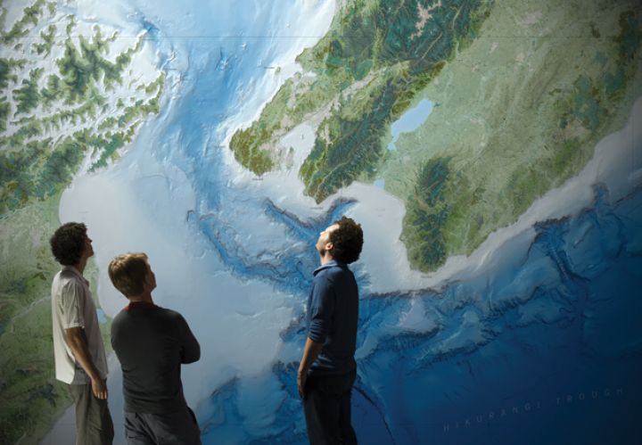
Fascinating maps of New Zealand’s seabed are now freely available on NIWA’s website.
Download the seabed
The maps will be useful for anyone interested in the New Zealand marine environment. NIWA geologist Dr Helen Neil says, “The maps include an extensive area of almost 12 million square kilometres. The area covered extends past the continental shelf and goes to depths of up to 11 000 metres.”
The maps come in a range of file formats. The choice starts from lowresolution images of the New Zealand region – from the Pacific Islands to the Southern Ocean – for use as a general resource. There’s a high-resolution image of the New Zealand region that you can zoom in on for more detailed information.
Top of the range are high-resolution GIS products gridded at 250 metres for use by mapping professionals.
Contact
Ozone hole receding?
New analysis combining satellite data and ground-based measurements shows that the 2010 Antarctic ozone hole is the smallest in five years. The ozone hole reached a maximum area of about 22 million square kilometres and a maximum ozone deficit of about 27 million tonnes in 2010. The largest Antarctic ozone hole ever recorded was in 2006 – about 29 million square kilometres and 43 million tonnes deficit.
While a one-year reduction in the ozone hole can’t, in itself, indicate a sustained long-term recovery, NIWA’s atmospheric experts say the results are encouraging and show that international initiatives to phase out the use of chlorofluorocarbons (CFCs) may
be working. NIWA scientists are also using sophisticated models on NIWA’s new supercomputer to estimate when ozone will recover to levels before the widespread use of CFCs.
Contact
Kaikoura Canyon – the hottest hotspot
The ocean around Kaikoura is not just popular with tourists, sperm whales, and albatrosses: it holds one of the most productive deepsea habitats known to science.
Recently published research reveals the bottom of Kaikoura Canyon – a large underwater canyon off the east coast of the South Island – hosts an astonishing number of fish, plus large invertebrates, burrowing sea cucumbers, and various marine worms. Scientists from NIWA and the University of Hawaii analysed samples of seafloor invertebrates, seafloor images, and bottom-trawl data from depths of up to 1400 metres in the canyon. These revealed invertebrate biomass values 100 times higher than any previously reported for deepsea habitats below 500 metres (other than those supported by hydrothermal vents).
There are at least 660 submarine canyons worldwide, of which about 100 could be biomass hotspots similar to the Kaikoura Canyon.
Contact
NIWA on the world stage
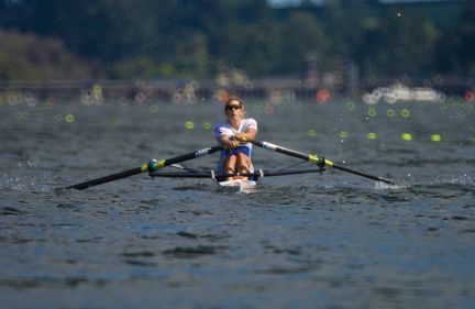
The 2010 World Rowing Championships held at Lake Karapiro in November attracted record-breaking crowds. Over 60 000 people from around the world came to see eight days of action, which included New Zealand crews winning ten medals. NIWA played a role behind the scenes, both before and during the rowing.
Working in collaboration with Land Information New Zealand, local authorities, and iwi, NIWA’s aquatic plant scientists spent four years before the event reducing hornwort in the lake. The aquatic weed can cause real trouble for rowing regattas if the plants get caught around the rower’s blades (oars) or the boat’s rudder, hindering speed and direction.
Once the racing began, NIWA provided localised forecasting using real-time data from weather stations on the dam and on a buoy on the course, together with sophisticated computer modelling. Detailed observations and forecasts of the course conditions helped organisers and competitors plan for each day of the event.
Fortunately, the local conditions were kind and racing was suspended only on one day. That was because of strong winds which made the course too choppy for world championship-level racing.
NIWA Principal Scientist Dr Mike Revell was on site throughout the Championships to provide regular briefings to the event organisers and officials from FISA, the international rowing federation. That advice included 10-minute observation updates and hourly forecasts of temperature, wind speed and direction, relative humidity, visibility, rain, cloud, and UV levels. The forecasting was provided through EcoConnect, NIWA’s environmental forecasting and information service. Tom Mayo, Chief Executive of the World Rowing Championships 2010 organising committee, said, “Accurate forecasting was crucial to the smooth running of the regatta. The service NIWA put together was world class.”
Contact
Culmination of first global marine census
After a decade of discovery, the world’s largest marine research collaboration is drawing to a close. The Census of Marine Life (CoML) has involved 2700 scientists from more than 80 countries in 540 expeditions to assess what, where, and how much, lives in the world’s oceans.
NIWA scientists have participated in 10 of the 17 CoML projects. Their work has included helping to set up the most comprehensive inventory of known marine life – which stands at nearly 30 million records and counting; mounting a major voyage to assess biodiversity in Antarctica’s Ross Sea; exploring the bizarre ecosystems supported by deepsea methane seeps and decomposing whale carcasses; estimating New Zealand’s past whale and seal populations; and leading the Census of Marine Life on Seamounts. The wealth of scientific knowledge and data generated by the census has detected human impacts on marine life, and will provide a baseline for studying future change in the world’s oceans.
Contact
Rapid response to quake
NIWA’s inspection report on the Christchurch City’s surface water flow monitoring sites after the September 2010 magnitude 7.1 earthquake shows just how much impact the shake had. “Bed has moved", “sudden surge inflows", and “cracks along the stream bank” are amongst the comments noted by NIWA’s field team.
The team worked long hours immediately after the earthquake, assessing data and restoring the waterflow measurement sites on the Avon, Heathcote, and Styx rivers.
“Our priorities were to get the sites and instruments back in order as quickly as possible, and ensure data quality and continuity for the Council,” NIWA team leader Marty Flanagan says. “We achieved this at almost all sites within a few days.”
The team was surprised at how much the response to the earthquake varied at different flow sites. At several locations, groundwater suddenly surfaced as springs, which, combined with liquefaction, triggered flow surges in many watercourses (see the figure).
All the monitoring sites have now been repaired and NIWA’s monitoring services have returned to normal – with site checks and reports provided to the Christchurch City Council every three months.
“Obviously our flow sites were not designed with such extreme and rare events in mind,” says John Fenwick, group manager of NIWA’s South Island field teams. “But most withstood the impacts and escaped with minor damage. The quick response of our field team straight after the quake really helped too.”
Contact
How-to guide for stream restoration
A new stream restoration toolkit is helping regional councils, community groups, and schools restore ailing streams back to health. NIWA and partners have produced an online guide to help identify restoration goals and choose indicators to measure progress. It also outlines how to design a monitoring programme, and when to expect success.
Common goals of stream restoration projects are often based around returning the stream to pre-human levels of biodiversity and water quality. “It’s about helping people to get going,” says NIWA freshwater scientist Dr John Quinn, “and defining where they are going, then helping them get there cost-effectively.” The toolkit – funded by the Envirolink Tools programme – is being used in projects to restore streams around New Zealand. It’s free to download from www.niwa.co.nz/ourscience/ freshwater/restoration_toolkit
Contact
Adapting to sea-level rise
NIWA is working with coastal communities and councils on how to adapt to sea-level rise caused by climate change. New Zealand sea levels are predicted to rise by between 18 and 59 centimetres by 2090, potentially exacerbating problems of coastal inundation and erosion. Forward planning is crucial for communities likely to be affected. NIWA is leading a three-year project which will map the vulnerability of the New Zealand coast to sea-level rise, and help councils and communities develop proactive adaptation strategies. As part of this, NIWA scientists ran three public forums in Whitianga last year, using maps to communicate the likely impacts of sea-level rise on Whitianga’s coast by the 2090s. They also canvassed the community on valued aspects of Whitianga that may be threatened, and discussed ways of managing these threats. This case study will help guide work with coastal communities throughout New Zealand.
Contact