Biological wonderland hidden beneath the Ross Sea.
One of our main tasks for this voyage is to better understand the geographic distribution - biogeography - of Antarctic organisms in the western Ross Sea, from the frozen coast out onto the continental shelf at 500m deep.
There are two main strands to this work. The first is a NIWA/University of Otago project, funded by the New Zealand Antarctic Science Platform, that seeks to understand the ecological variability between 50 to 100m deep, along 500km of the Victoria Land coast. The second strand is an Italian funded project that is looking at bioconstructions (colony building organisms such as corals, bryozoans, and sponges) at depths of 300-500m. These complementary projects will contribute to a fundamental understanding of how this rich seafloor ecosystem will be impacted by climate change, a warming ocean, reduction in sea ice, and an increase in ocean acidity.
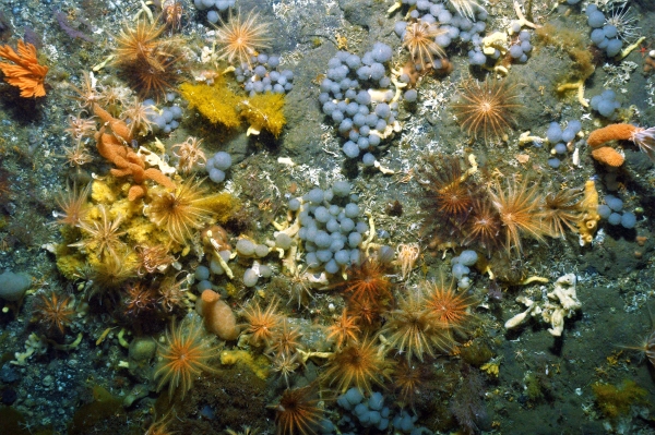
Photo: Colonial ascidians (grapes), crinoids (feather stars) and primnoid corals (orange) make up part of the Ross Sea ecosystem. [Image taken with DTIS (Deep Towed Imaging System), NIWA]
We have now visited 23 separate sites in these coastal areas, albeit some of them very close together. Every time we visit a new site, we first need to map the seafloor as we are working in unchartered coastal waters. To do this we use a multibeam echosounder that maps a strip of the seafloor under the vessel, giving us an accurate 3D map of the seabed below. We carefully approach from deep water and gradually move towards the shallows, keeping the ship over the mapped area of the seafloor the whole time. Once we have mapped the area that we want to work in, we plan a video transect.
Our Deep Towed Imaging System (DTIS) is a camera that can be lowered alongside the boat and ‘flown’ by the crew operators close to the seafloor as the boat moves slowly in one direction along a transect. A live-feed back to the ship allows scientists to log what can be seen across an approximately 2m-wide swath along our transect strips. DTIS is our main tool for understanding the structure of the ecosystem below – what lives there, in what numbers, plus the general habitat. In most cases we are the first people to witness the inhabitants of this unique environment.
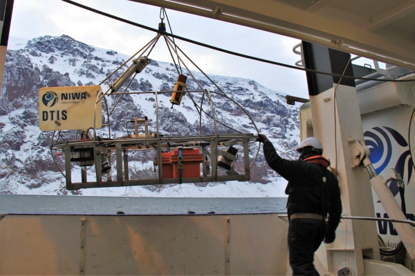
Photo: DTIS being deployed on a cold day. DTIS has downward looking HD video and stills cameras, flood lights and measurement lasers. It can be used in over 3000m water depth and is the workhorse of deep-sea ecology for New Zealand marine science, [Credit: Van Wyk / NIWA]

As well as collecting videographic information about the ecological structure of the seafloor, we also want to understand the water chemistry and the sediment composition. We analyse the former by collecting water samples with the CTD and the latter using a sediment corer or grab.
With all this information under our belt, we can make a decision about which animals to physically collect as specimens. These specimens will be analysed back in the laboratory in New Zealand for eDNA and isotopic signatures. The specimens are meticulously catalogued and preserved in different ways for later examination and there are strict processes for reporting which specimens we have taken from where, so that they can be imported back to New Zealand. Bring on the paperwork.
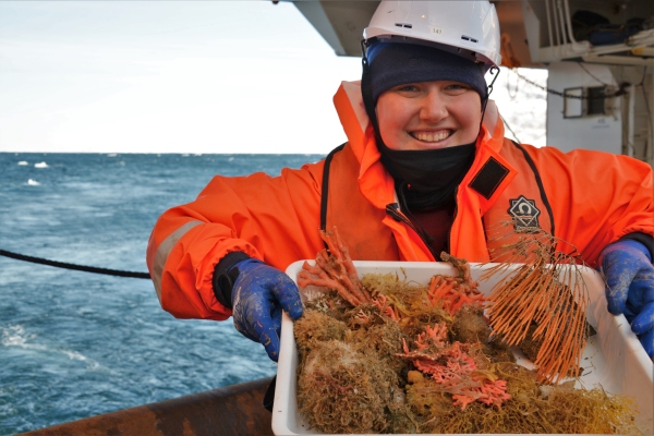
Photo: Victoria University MSc student Emma De Jong holding new specimens for curation and analysis. [Credit: Joshu Mountjoy / NIWA]
For a trained geoscientist with minimal exposure to biological sciences, it has been astonishing to see the incredible richness of life on the Antarctic sea floor. The video images flowing in, and the vibrancy of this ecosystem, are amazing considering water temperatures are under 0°C and the region is covered in sea ice for approximately 10 months of the year. Fortunately, we also have a full team of experienced biologists onboard RV Tangaroa who can lead this side of the science.
In five days, we will turn back to begin our return journey to Wellington. Most recently we have been dodging sea ice and icebergs looking to recover samples from seafloor fluid seeps. We are currently heading south towards Terra Nova Bay where we hope to recover our last mooring from inside the polynya – provided there is a break in the ice bridge.
It’s fair to say that the working environment here is both beautiful, and incredibly challenging.
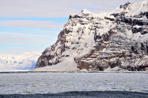
Photo: Cape Wheatstone at the southern end of the Hallett Peninsula with the Tucker Glacier ice tongue behind. We had planned to be around the cape by the ice tongue on Tuesday night, but the sea ice had other ideas. [Credit: Joshu Mountjoy / NIWA]
Voyage leader,
Dr Joshu Mountjoy