PDF of this article (269 KB)
Carolyn Lundquist Sara Hatton
Can estuaries recover from sedimentation? Models and field experiments are starting to provide some answers.
There is little doubt that New Zealand’s estuaries are getting muddier (see “How will habitat change affect intertidal animals in estuaries?”). Several research projects have examined the direct effects of fine sediment on the animals that live in estuaries (for example, see “Determining impacts on marine ecosystems” in an earlier issue of Water & Atmosphere). But other questions remain: Do estuaries recover from events that cause sedimentation? How might this happen? Is it possible to make predictions to identify which areas or habitats are most, or least, likely to recover?
When an area of estuary has been affected by a disturbance such as a sediment dump, recovery depends on many factors. Are enough animals nearby to recolonise the area? How far can waves, tides and storms carry animals of various sizes? How long is the area under water?
Models and measurements

We have developed simple models to predict the transport of colonising animals into disturbed parts of an estuary. For example, exposed estuarine sandflats are predicted to receive more colonisers than high intertidal areas such as mudflats and tidal creeks; and strong tidal currents lead to higher transport rates than neap tides and calm conditions.With the predictions of the model in mind, we designed a field experiment to explore the potential for recolonisation in different habitats in an estuary. We looked at two factors:
- differences among sites in the numbers of animals brought into the area;
- the effects of physical conditions like tidal currents and waves.
We made measurements and observations at 7 sites in the Whitford embayment, Auckland, in December 2001 and February 2002. Five sites were in the estuary itself: four sandflat sites (upper and lower areas) and one next to the main channel, so that each site had a different time under water. There were also two intertidal sites (called the mud and mangrove sites) in Mangemangeroa Creek, upstream of the estuary.
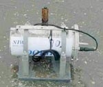
At each site we installed sediment traps to collect animals transported along the sediment surface and animals floating in the water. Wave gauges (DOBIEs) and other instruments gave information on water depth, wave height, water flow at the sediment surface, the amount of sediment in the water, and currents caused by tides or wind at each site.
Here we discuss the results from our first set of measurements on 10–14 December 2001. During this time there were spring tides, and both calm weather and a storm. We show differences in physical conditions using data from 3 of the sites. Differences in colonising animals are illustrated for all 7 sites. (see PDF of this article)
Differences highlighted
During the storm, at all sites we measured more suspended sediment on incoming and outgoing tides than during the periods between tides. During the calm period, this pattern occurred only in the tidal creek.

As the graph shows, larger waves during the storm on 10–12 December caused more water movement at the sediment surface at the upper sandflat site than at the lower sandflat site, because of shallower water at the upper site. But in the tidal creek (mud site), there were no waves at all, even in the storm.
The information collected by the wave gauges and other instruments gave us a picture of how animals might be transported by tidal currents only (measurements made in calm conditions), and how they might be transported by tides plus storm-generated waves.
The number of animals collected in traps clearly showed the role of waves in transporting organisms. During the windy period, 10–20 times more animals were collected in the traps at all the sandflat sites than in the calm period. The traps at the site in the channel and the two tidal creek sites collected consistently lower numbers of animals than those at all four sandflat sites, though there was still an increase during windy conditions.
Collecting animals at different heights showed that more organisms were transported just above the sediment surface (along with the sediment itself) than up in the water column. Since we expect sediment on the seabed to move shorter distances than sediment carried higher up in the water, the result suggests that most of the animals are moved only short distances by waves. This implies that large disturbed areas may take much longer to recover than smaller, more localised disturbances, because colonist animals are much farther away.
The importance of waves
Our results suggest that small waves generated within harbours or estuaries are important in recolonisation of disturbed intertidal soft-sediment areas. We also showed that the rate of colonisation varies among different locations within an estuary.
We are using the results from these modelling and field studies to develop general models of estuarine recovery after disturbance. The general models can then be applied to other estuaries to predict areas or habitats that are most sensitive to, and are least likely to recover from, increasing sedimentation.
Teachers: this article can be used for NCEA Achievement Standards in Biology (2.5, 2.9, 3.1, 3.2), Science (2.2, 2.3), Geography (3.1). See other curriculum connections at www.niwa.co.nz/pubs/wa/resources
Jane Halliday, Simon Thrush, Judi Hewitt and Greig Funnell are all based at NIWA in Hamilton.
Acknowledgement
This research was carried out in the FRST-funded programme “Effects of Sediments on Estuarine and Coastal Ecosystems” (C01X0024).