Southwest Pacific Tropical Cyclone Outlook: Near-normal season expected, but with increased activity west, reduced activity east.
Forecasters say about eight to 10 named tropical cyclones are expected to form in the Southwest Pacific basin between November and April.
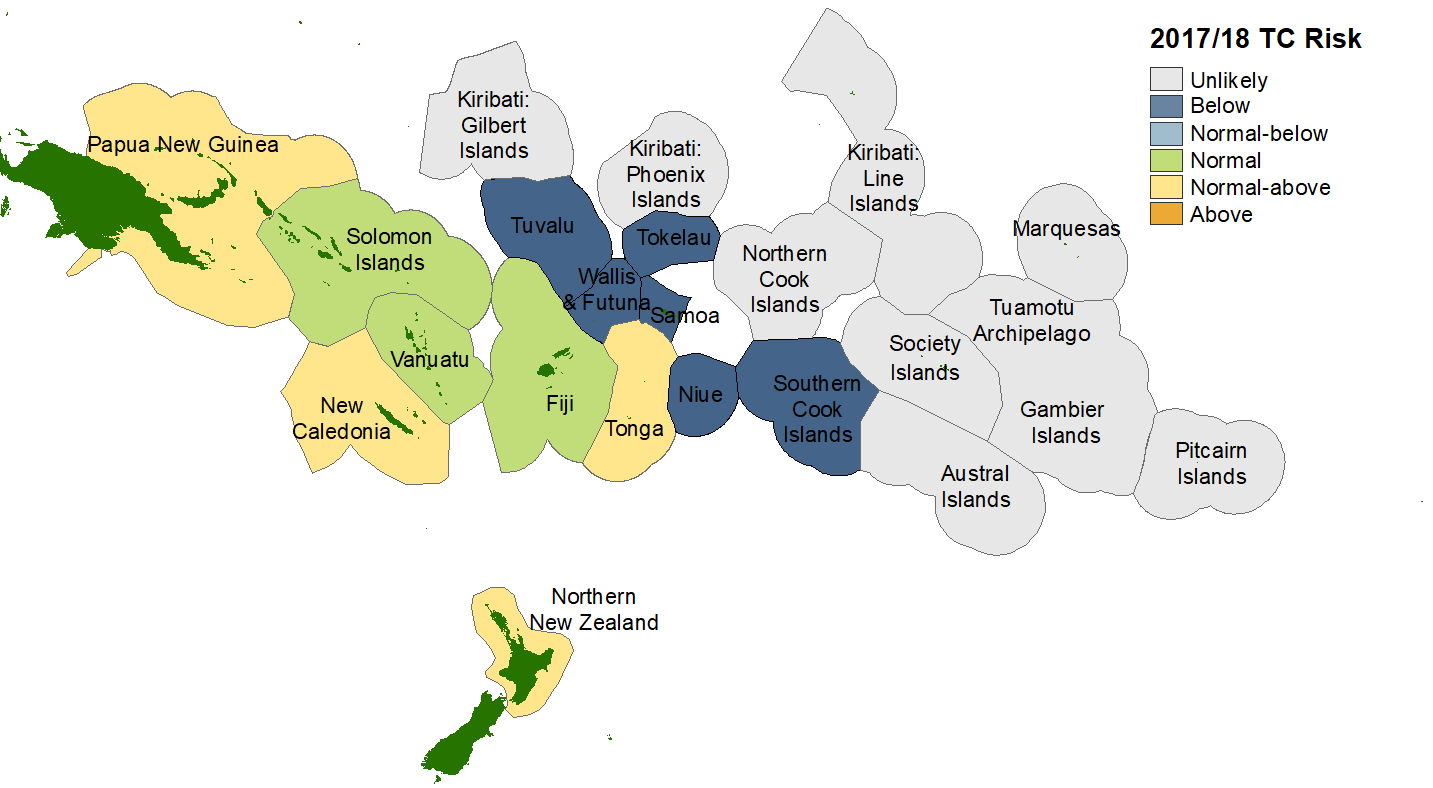
Analysis by forecasting centres across the Southwest Pacific show tropical cyclone activity is expected to higher around the Coral Sea and west of the International Date Line, and lower further east.
New Caledonia, Fiji, Vanuatu and Tonga may experience two or more cyclones during the season, while three or four severe cyclones of Category 3 of higher, are expected anywhere across the region during the season that starts next month and lasts until the end of April.
On average, at least one ex-tropical cyclone passes within 550km of New Zealand each year. For the coming season, forecaster say the risk for New Zealand is considered normal or above normal. If an ex-tropical cyclone comes close to the country, it has equal probability of passing east or west of Auckland and the North Island. Significant rainfall, damaging winds and coastal damage can occur leading up to and during these events.
Oceanic and atmospheric forecasts for ENSO (El Niño-Southern Oscillation) indicate La Niña conditions are expected to develop by summer. At present, sea surface temperature anomalies across the central and eastern equatorial Pacific Ocean and atmospheric circulation patterns over French Polynesia and northern Australia indicate conditions are ENSO-neutral, but leaning toward La Niña.
If La Niña conditions develop, they are likely to result in a significant change from normal tropical cyclone activity in many Pacific Islands.
Islands on the fringe of the north Coral Sea, including Papua New Guinea, the Solomon Islands, Vanuatu, New Caledonia and Tonga may experience slightly increased activity. Reduced activity is expected in some islands, especially those east of 160°W longitude, including the Cook Islands, the Marquesas and French Polynesia.
Tropical cyclones are categorised in strength from 1 to 5, with 5 being the most intense. For the coming season, about four storms are anticipated to reach at least Category 3, with mean wind speeds of at least 118 km/h winds). Of these, two may increase to at least Category 4 strength, with mean wind speeds of 159 km/h. Category 5 strength cylcones where winds are greater than 196 km/h, have occurred during seasons with similar antecedent conditions to 2017/18 (known as ‘analogue’ seasons). Therefore, all communities should remain alert and well-prepared for severe events.
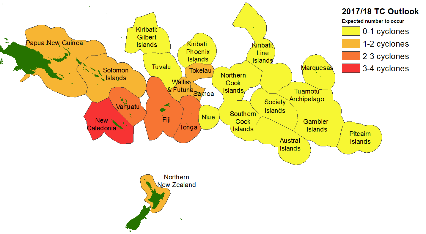
Tropical cyclones have a significant impact across the Southwest Pacific. Vanuatu and New Caledonia typically experience the greatest activity, with an average of two or three named cyclones passing close to land each year.
New Zealand should also be vigilant. During some analogue seasons used in the preparation of this outlook, multiple ex-tropical cyclones passed within 550 km of the country. Significant wind, waves and rainfall are possible from these systems. Their effects can be spread over a larger area, particularly if the ex-tropical cyclone interacts with separate weather systems.
Tropical cyclone activity is expected to be reduced for some countries during this season, especially for islands to the east of 160°W longitude, including the Cook Islands, the Marquesas and French Polynesia. As with most years, activity is expected to increase during the second half of the season, from February-April.
All Pacific Islands should remain vigilant in case conditions in the equatorial Pacific (including ENSO) change during the season. Analogue seasons have seen intensification to well-coupled La Niña conditions and strong increases in storm activity west of the Dateline in the late season. NIWA, MetService, MeteoFrance, BoM, NOAA and Pacific Island National Meteorological Services will all continue to track the progression of ENSO and there will be an update to this guidance in January 2018 if needed.
New Zealand’s National Institute of Water & Atmospheric Research (NIWA) and Meteorological Service of New Zealand (MetService) along with contributions from meteorological forecasting organizations from the Southwest Pacific, including the Australian Bureau of Meteorology, MeteoFrance and the Pacific Island National Meteorological Services have prepared this tropical cyclone outlook.
Contacts
In New Zealand:
Mr. Chris Brandolino - Principal Scientist - Forecasting, NIWA
Mr. Chris Noble - Manager, Specialist Weather Services, MetService New Zealand Tel: +64 4 470 1175
Mrs. Elke Louw - Wellington RSMC (Regional Specialized Meteorological Centre), Manger, Marine Weather Services, MetService New Zealand Tel: +64 4 470 0737
Mr. Ben Noll - Forecaster, NIWA
In the Pacific Islands, please contact your local national meteorological service for information about how this guidance should be interpreted.
For Australia and associated offshore islands, please contact the Australian Bureau of Meteorology for information about how this guidance should be interpreted.
For French Polynesia and New Caledonia, please contact MeteoFrance for information about how this guidance should be interpreted.
