A weekly update describing soil moisture across the country to help assess whether severely to extremely dry conditions are occurring or imminent. Regions experiencing these soil moisture deficits are deemed “hotspots”. Persistent hotspot regions have the potential to develop into drought.
Facts: Soil Moisture
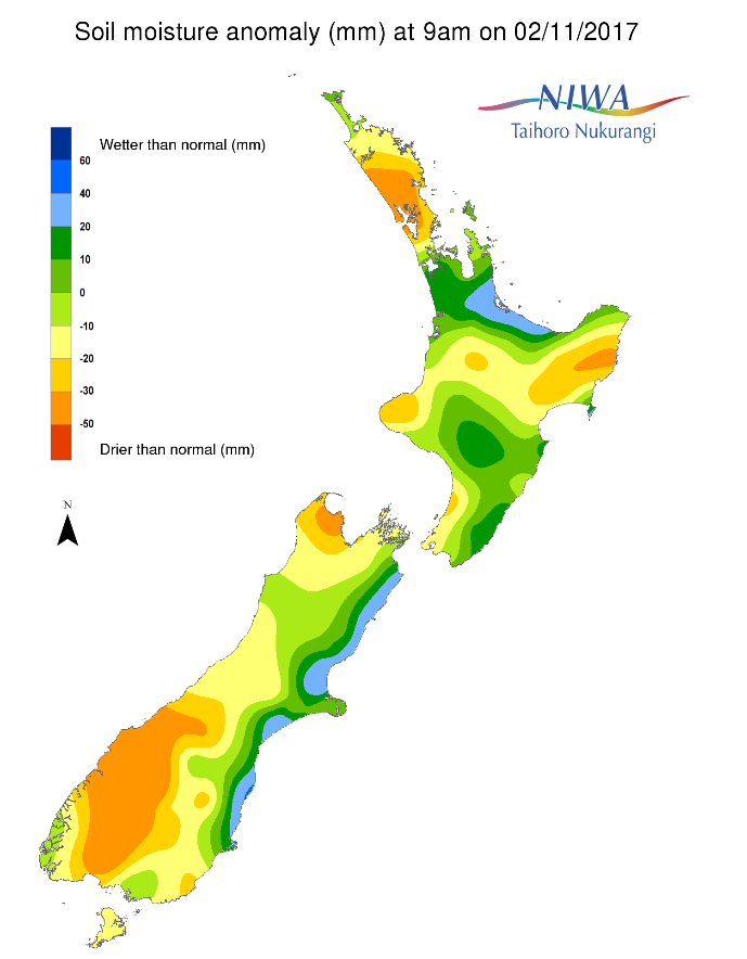
Across the North Island, soil moisture levels have decreased in many places over the last week, including Auckland, Northland, Taranaki, Hawke’s Bay, and Wellington. Soil moisture levels, however, increased in Bay of Plenty and Waikato. The driest soils across the North Island compared to normal for this time of the year are found in Gisborne and Northland, while the wettest soils are in Bay of Plenty. In the North Island, a small hotspot has emerged in coastal Gisborne.
Across the South Island, soil moisture levels have generally decreased during the past week. Soil moisture is well below normal for the time of year across interior Otago, much of Southland, lower Westland, and most recently the northwest Tasman region. Meanwhile, the wettest soils for the time of year are found along the eastern coast from Kaikoura to Dunedin.
The hotspot located in parts of Central Otago and Waitaki has slightly increased in size and strength during the past week and has expanded into the eastern Queenstown-Lakes region.
Outlook and Soil Moisture
Active weather is likely across New Zealand over the next week, with abundant rainfall expected in the west and north of both islands.
For the North Island, high pressure will give way to rainfall associated with a front on Friday, totalling 5 to 10 mm in the western and northern part of the island but less than 5 mm in the east. On Saturday, isolated showers are forecast to bring 5 mm or less to the west and north. On Sunday, another front will move across the central North Island, bringing another 5 to 10 mm of rain. After generally dry conditions on Monday and Tuesday, a stronger front may move across the island on Wednesday, bringing locally heavy rainfall. At this point, 10 to 25 mm looks most likely, especially in western and northern parts. Lingering showers (up to 5 mm) are possible on Thursday before dry conditions occur under high pressure on Friday.
With abundant rainfall amounts generally expected across the North Island, no new hotspots are expected to form. Most dry areas will see noticeable improvement, however Hotspot conditions in Gisborne may remain the same or improve slightly.
On Friday, areas of heavy rainfall are expected across the western and upper South Island with 10 to 25 mm of rain expected, though locally higher amounts are possible in Westland. Hit and miss showers and thunderstorms are forecast across Otago and Southland, with some locations receiving as much as 10 mm while others may see very little. On Saturday and Sunday, rain will continue from Fiordland through the West Coast with another 10 to 25 mm expected each day. Passing showers may bring up to 5 mm in Otago and Southland on Saturday and Sunday, then a few millimetres in southern Canterbury later Sunday. On Monday, periodic showers may bring 5 to 10 mm of rain to Fiordland and the West Coast and no more than 5 mm to Southland and Otago.
On Tuesday, a potent low pressure system and front may move up the island, bringing heavy rainfall to those in the west and north possibly totalling 25 to 50 mm with local amounts to 75 mm. Eastern areas may receive 5 mm of rain with the heaviest totals remaining in or west of the Southern Alps. From Wednesday into Thursday, showers will continue across the island, totalling about 10 mm each day in the west and less than 5 mm in the east. Isolated showers are likely to persist on Friday, though forecast amounts are minimal with high pressure building in from the west.
Due to widespread rainfall, soil moisture levels are likely to increase almost everywhere in the South Island during the next week. The hotspot in Central Otago, Waitaki, and Queenstown-Lakes will likely improve, but may not be entirely alleviated. No new hotspots are expected to develop over the next week.
Background:
Hotspot Watch: a weekly advisory service for New Zealand media. It provides soil moisture and precipitation measurements around the country to help assess whether extremely dry conditions are imminent.
Soil moisture deficit: the amount of water needed to bring the soil moisture content back to field capacity, which is the maximum amount of water the soil can hold.
Soil moisture anomaly: the difference between the historical normal soil moisture deficit (or surplus) for a given time of year and actual soil moisture deficits.
Definitions: “Extremely” and “severely” dry soils are based on a combination of the current soil moisture status and the difference from normal soil moisture (see soil moisture maps)