A weekly update describing soil moisture across the country to help assess whether severely to extremely dry conditions are occurring or imminent. Regions experiencing these soil moisture deficits are deemed “hotspots”. Persistent hotspot regions have the potential to develop into drought.
Facts: Soil Moisture
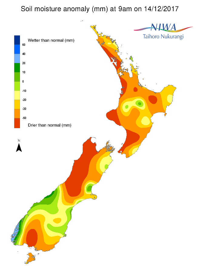
Across the North Island, soil moisture levels in most locations have generally not changed substantially during the past week. However, substantial rainfall of 15-40 mm on Wednesday and Thursday morning (13th-14th December) across Wairarapa and the east coast of the Wellington region has led to improvements in soil moisture levels there. In fact, this rainfall ended an approximately 30-day dry stretch in the Wellington region. Small decreases in soil moisture were observed in Gisborne, Bay of Plenty, Coromandel Peninsula, and the Far North. The driest soils across the North Island compared to normal for this time of the year are found in Kaipara District, northern Auckland, western Waikato, much of Taranaki, a small portion of the Whakatane District, and Manawatu District south to the Kapiti Coast and Wellington City, while the wettest soils for this time of the year are located in a small portion of central Waikato.
North Island hotspots are currently in place across Kaipara District, nearly all of Auckland, far northwest Waikato, coastal Taranaki, coastal Manawatu-Whanganui south to Kapiti Coast and Wellington City, and much of the east coast from southern Gisborne to Masterton District.
Across the South Island, soil moisture levels increased significantly in Fiordland and Westland during the past week due to substantial rainfall. Notable improvements were also observed across much of Canterbury, Otago, and Marlborough due to moderate to heavy rainfall occurring on Wednesday and Thursday morning (13th-14th December). This rainfall ended a 47-day dry stretch at Christchurch Airport. Soil moisture improvements were also noted in Southland during the past week. However, little change in soil moisture levels occurred in the northern West Coast, Tasman, and Nelson. The driest soils across the South Island compared to normal for this time of the year are found in Tasman, Nelson, the northern West Coast, and southern Southland, while the wettest soils for this time of the year are found in Fiordland.
South Island hotspots are currently located in northern Tasman and Nelson, parts of northern and interior Canterbury (although these have decreased in size and strength during the past week), and a small portion of southern Southland. Meanwhile, previous hotspots in coastal Marlborough, south Canterbury, Clutha District, and eastern Southland dissipated due to substantial rainfall.
Outlook and Soil Moisture
Primarily dry weather is expected in the North Island on Friday and Saturday as high pressure sits overhead. Pop-up showers will be possible in the central and upper North Island on Sunday afternoon (17th December), but any rainfall will generally be 5 mm or less. More significant rain will be possible on Monday as a front could bring 10-20 mm to the east coast, and up to 10 mm elsewhere. With the exception of isolated light showers, mostly dry weather is expected to return from Tuesday through to Thursday (19th-21st December) due to high pressure nearby.
Due to the expected rainfall, minor improvements in soil moisture levels will be possible along the east coast during the next week, while elsewhere in the North Island soil moisture levels could continue to decrease at least slightly. This may lead to strengthening and enlargement of existing hotspots in Northland, Auckland, northwestern Waikato, Taranaki, and Manawatu-Whanganui to Wellington, while those along the east coast will not change significantly.
In the South Island, a front will bring 25-50 mm to Fiordland and southern Westland on Friday and Saturday morning (15th-16th December), with less than 10 mm in Southland and Otago. A second front has a better chance to deliver moderate rainfall to the eastern South Island on Sunday and Monday, with 15-25 mm possible. Tuesday (19th December) will be mostly dry, but another front could produce an additional 5-10 mm in the lower South Island late Wednesday into Thursday. Unfortunately the upper South Island is expected to miss out on the bulk of the rain from these fronts during the next week, where rainfall could remain below 15 mm.
Further improvements in soil moisture levels will be possible during the next week in Fiordland, Westland, Otago, and southern Canterbury, while drier soils are likely to occur in the upper South Island and northern Canterbury. This will cause the hotspots to strengthen in Tasman, Nelson, and northern Canterbury, while the previous hotspot in coastal Marlborough could re-emerge.
Background:
Hotspot Watch: a weekly advisory service for New Zealand media. It provides soil moisture and precipitation measurements around the country to help assess whether extremely dry conditions are imminent.
Soil moisture deficit: the amount of water needed to bring the soil moisture content back to field capacity, which is the maximum amount of water the soil can hold.
Soil moisture anomaly: the difference between the historical normal soil moisture deficit (or surplus) for a given time of year and actual soil moisture deficits.
Definitions: “Extremely” and “severely” dry soils are based on a combination of the current soil moisture status and the difference from normal soil moisture (see soil moisture maps)