A weekly update describing soil moisture patterns across the country to show where dry to extremely dry conditions are occurring or imminent. Regions experiencing significant soil moisture deficits are deemed “hotspots”. Persistent hotspot regions have the potential to develop into drought.
Recent rainfall and current soil moisture conditions:
North Island:
- Rainfall totals of 10-25 mm were generally observed in the eastern North Island in the past week, although northern Hawke’s Bay saw an area of 30-40 mm.
- However, it was another week of generally meagre rainfall for the rest of the North Island, where totals were mostly 10 mm or less.
- Small to moderate soil moisture decreases were observed across nearly the entire North Island in the past week.
- The driest soils across the North Island, when compared to normal for this time of the year, are found in eastern Northland, the northern Coromandel Peninsula, and parts of Taranaki and Wellington, while the wettest soils for this time of the year are found in western and southern Waikato.
- Hotspots are currently located across most of Northland, northern Auckland, northern Coromandel Peninsula, parts of coastal Bay of Plenty and Gisborne, southern Hawke’s Bay to Wairarapa, and coastal Manawatū-Whanganui to Kāpiti Coast.
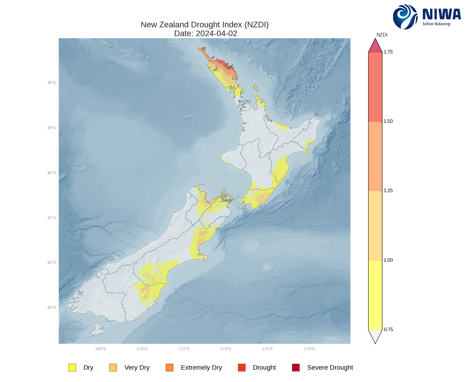
- As of 2 April, the New Zealand Drought Index (NZDI) map below shows that abnormally dry conditions are currently found in Northland, northern Auckland, northern Coromandel Peninsula, southern Hawke’s Bay, southern Manawatū-Whanganui, and Wellington. Very dry to extremely dry conditions are located in much of Northland and Wellington, while parts of eastern Northland are now experiencing meteorological drought.
South Island:
- Much of the West Coast and Fiordland received 20-50 mm in the past week, with up to 25 mm in Southland.
- However, the upper and eastern South Island again received meagre rainfall amounts of 5 mm or less.
- This resulted in small soil moisture decreases across the entire South Island.
- The driest soils across the South Island, when compared to normal for this time of the year, are found in northern Tasman, while the wettest soils for this time of the year are found in western Southland.
- Hotspots are currently located across northern and eastern Tasman, Nelson, parts of Marlborough, and northern and central Canterbury, while southern Canterbury and eastern Otago are near hotspot status.
- As of 2 April, the New Zealand Drought Index (NZDI) map below shows that abnormally dry conditions are currently found in northern Tasman, Nelson, parts of Marlborough, several parts of Canterbury, and northern Otago. Very dry to extremely dry conditions are located in northern Tasman, Nelson, western Marlborough, parts of northern and far southern Canterbury, and northern Otago.
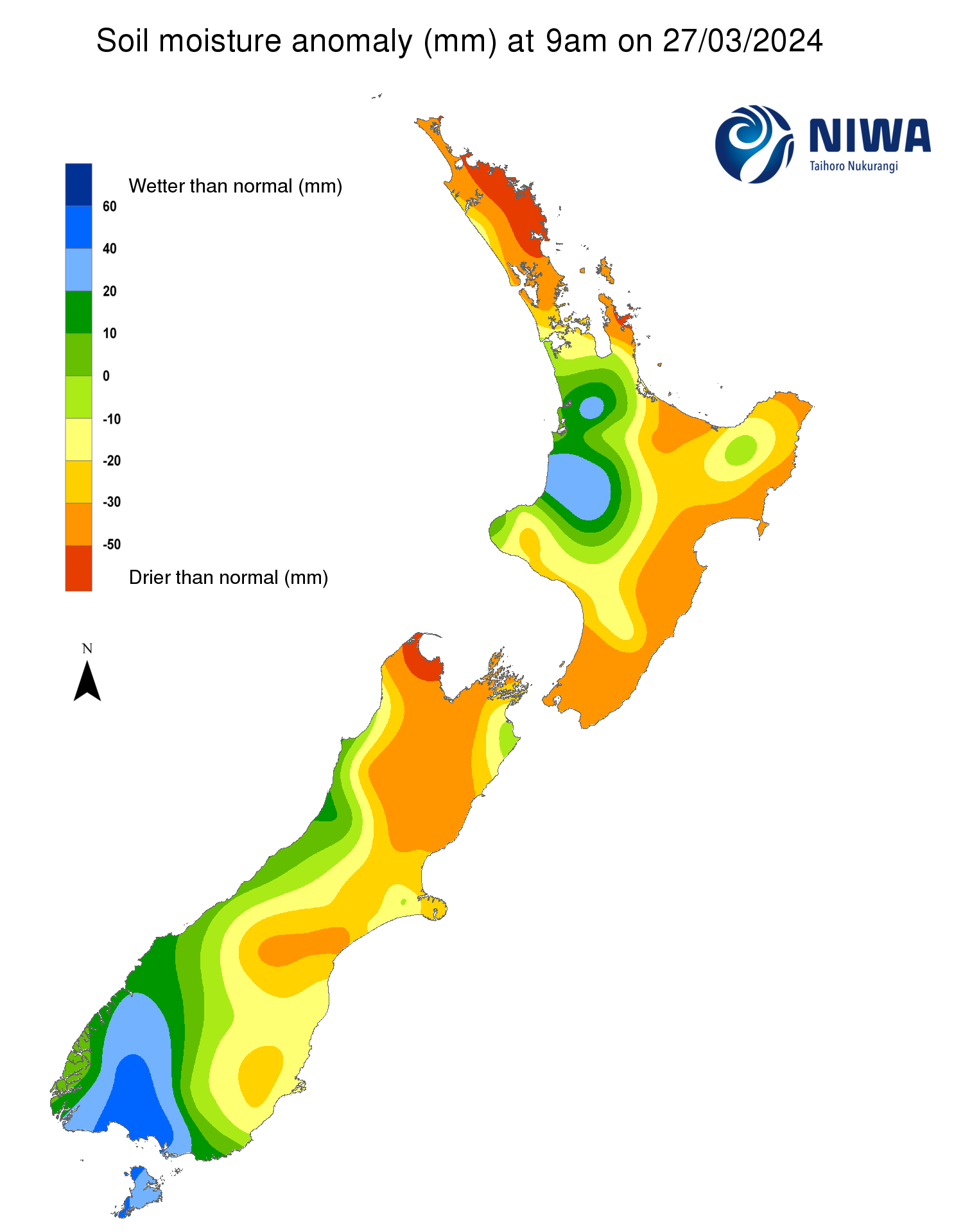
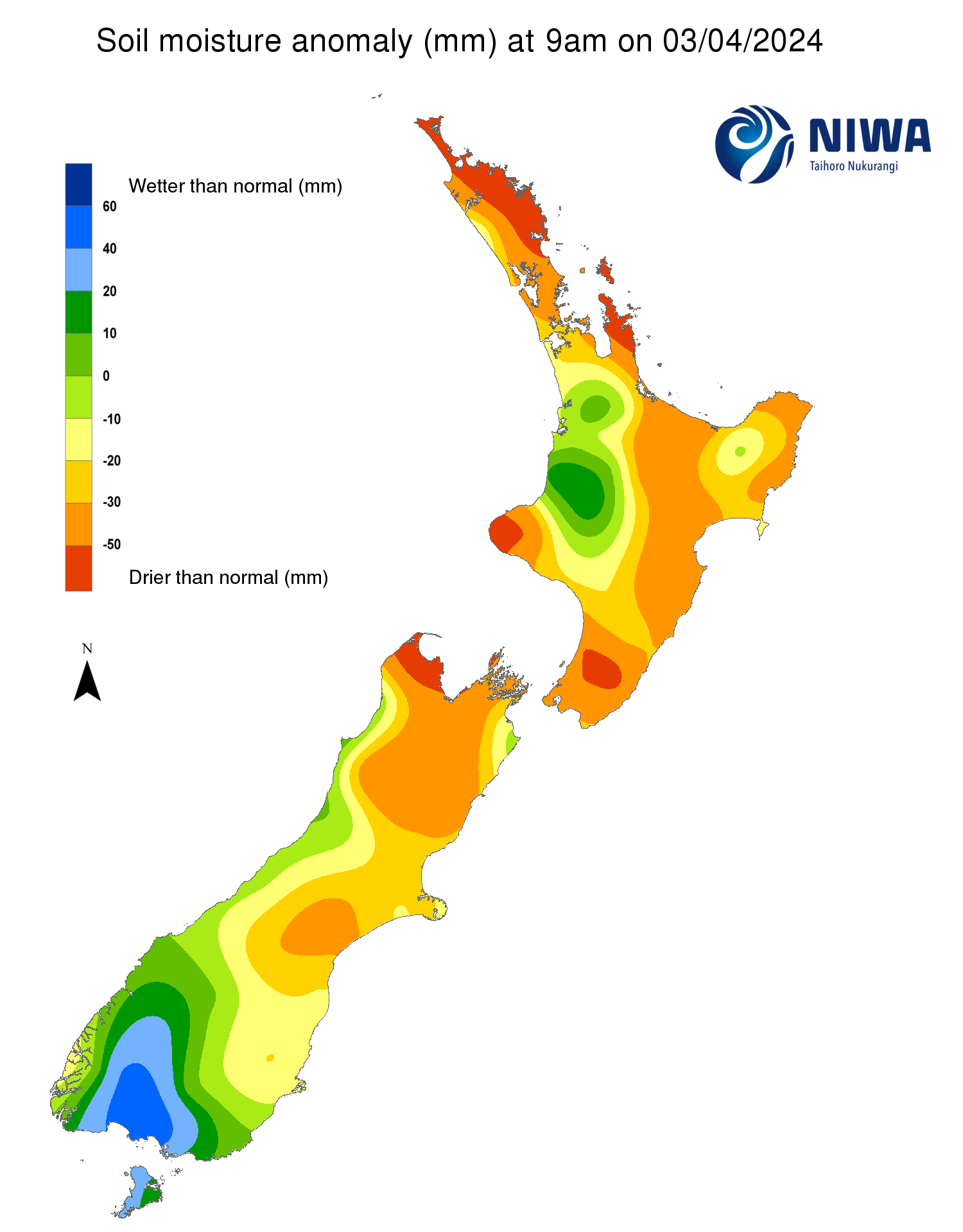
Pictured above: Soil Moisture Anomaly Maps, relative to this time of year. The maps show soil moisture anomalies over the past two weeks.
As of 2 April, the New Zealand Drought Index (NZDI) map below shows that abnormally dry conditions are currently found in Northland, northern Auckland, northern Coromandel Peninsula, southern Hawke’s Bay, southern Manawatū-Whanganui, Wellington, northern Tasman, Nelson, parts of Marlborough, several parts of Canterbury, and northern Otago. Very dry to extremely dry conditions are located in much of Northland, Wellington, northern Tasman, Nelson, western Marlborough, parts of northern and far southern Canterbury, and northern Otago. In addition, parts of eastern Northland are experiencing meteorological drought. Please note: some hotspots in the text above may not correspond with the NZDI map. This difference exists because the NZDI uses additional dryness indices, including one which integrates the rainfall deficit over the past 60 days. Changes are therefore slower to appear in the NZDI compared to soil moisture anomaly maps that are instantaneously updated.
The week ahead:
North Island:
- A front will move up the North Island through Friday morning (5 April), bringing showers to most regions.
- From Friday afternoon, high pressure will deliver several consecutive days of generally dry weather through Wednesday of next week (10 April).
- However, an area of low pressure could bring moderate to heavy rain to the North Island around Thursday-Friday (11-12 April).
- Weekly rainfall totals could reach 25-50 mm across much of the North Island by late next week, with isolated higher amounts. However, rainfall totals along the east coast may be lower.
- Due to the expected rainfall in the next week, at least small soil moisture increases are likely across much of the North Island, although little change may occur along the east coast.
- Current hotspots in the upper and western North Island will have the best chance to ease somewhat in the next week, while those located along the east coast may not change significantly.
South Island:
- High pressure will result in mostly dry weather across the South Island through Monday (8 April).
- However, Tuesday through Thursday (9-11 April) look to be quite active, with heavy rain impacting the western South Island and some rain spilling over into the eastern South Island.
- Weekly rainfall totals could be quite substantial in the West Coast, with 200-400 mm possible.
- Amounts of 40-75 mm will be possible in the upper South Island, with 30-50 mm in the lower South Island.
- However, lower rainfall amounts of 25 mm or less are possible along the east coast.
- Due to the expected rainfall in the next week, meaningful soil moisture increases will be likely in the western and upper South Island, with smaller increases in the south, and little change along the east coast.
- The current hotspots in the upper South Island may ease moderately to substantially in the next week, while those located in Canterbury may not change substantially.
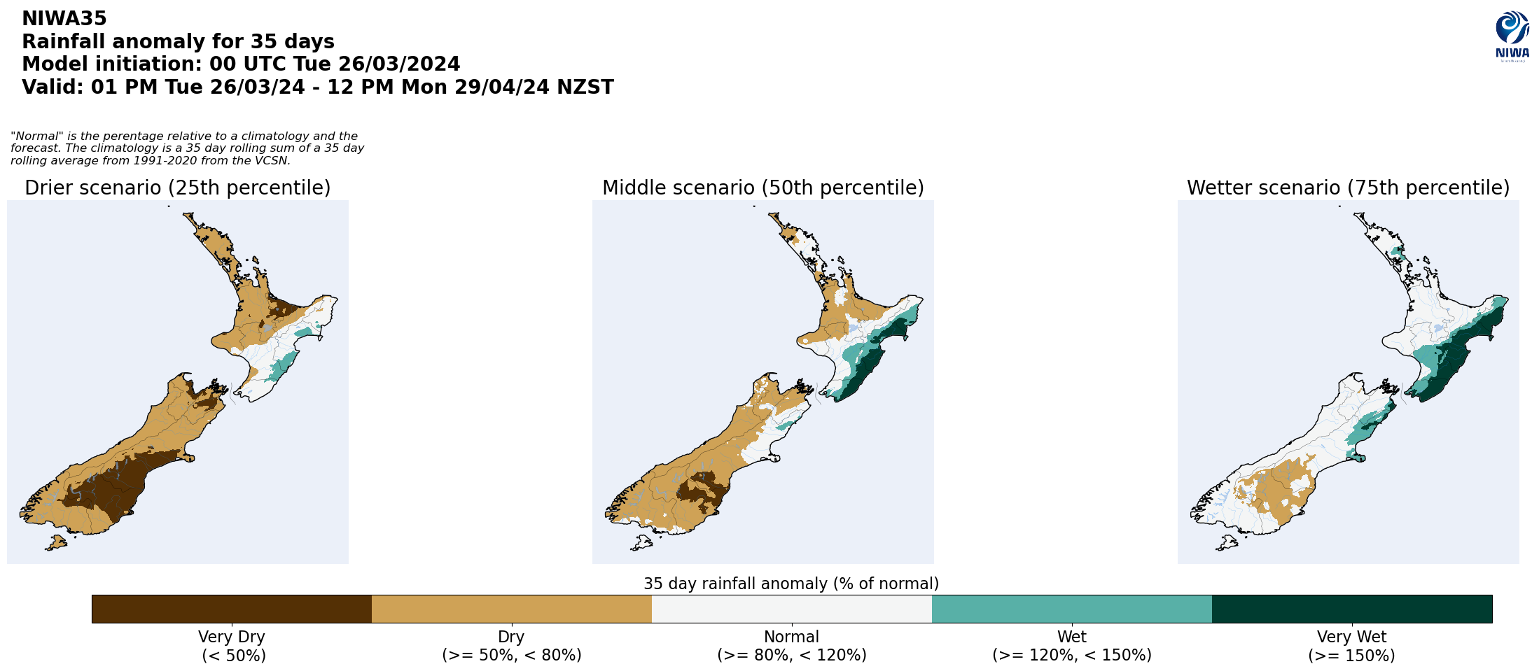
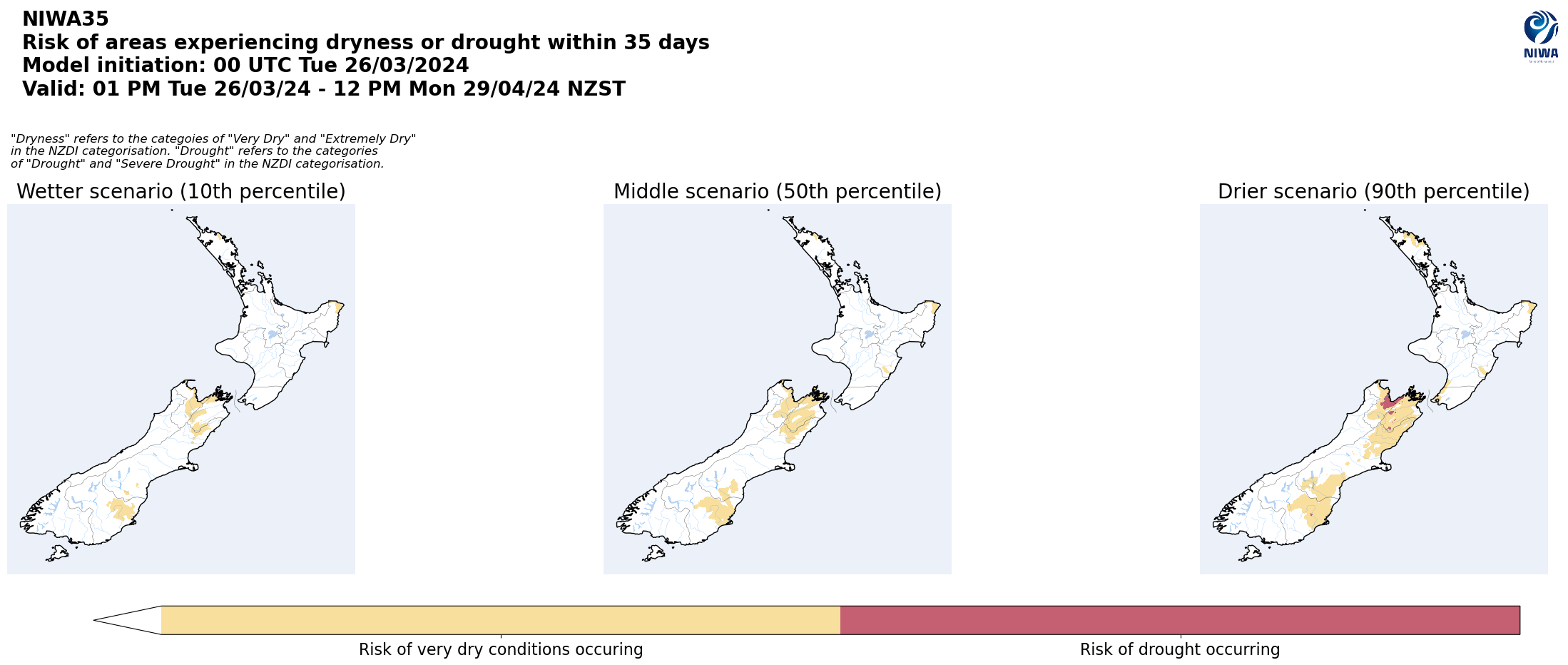
Long-term outlook (through early May):
- The drier (25th percentile) and middle (50th percentile) rainfall scenarios both show drier than normal conditions across much of both islands, leading to higher confidence for that outcome.
- In the middle (50th percentile) scenario and wetter (75th percentile) scenario, near normal to above normal rainfall is signalled in the eastern North Island and parts of the West Coast.
- Very dry soil conditions will affect the upper and eastern South Island in all three rainfall scenarios, with areas of meteorological drought signalled in the upper South Island in all three scenarios.
Pictured above: 35-day forecast rainfall anomaly scenarios (Top), and 35-day forecast dryness and drought scenarios (Bottom). These maps are updated daily at https://niwa.co.nz/climate/seasonal-climate-outlook
Background:
Hotspot Watch: a weekly advisory service for New Zealand media. It provides soil moisture and precipitation measurements around the country to help assess whether extremely dry conditions are imminent.
Soil moisture deficit: the amount of water needed to bring the soil moisture content back to field capacity, which is the maximum amount of water the soil can hold.
Soil moisture anomaly: the difference between the historical normal soil moisture deficit (or surplus) for a given time of year and actual soil moisture deficits.
Definitions: “Extremely” and “severely” dry soils are based on a combination of the current soil moisture status and the difference from normal soil moisture (see soil moisture maps at https://www.niwa.co.nz/climate/nz-drought-monitor/droughtindicatormaps)
Hotspot: A hotspot is declared if soils are "severely drier than normal" which occurs when Soil Moisture Deficit (SMD) is less than -110 mm AND the Soil Moisture Anomaly is less than -20 mm.