A weekly update describing soil moisture across the country to help assess whether severely to extremely dry conditions are occurring or imminent. Regions experiencing these soil moisture deficits are deemed “hotspots”. Persistent hotspot regions have the potential to develop into drought.
Facts: soil moisture
Across the North Island, soil moisture levels increased in many places during the past week. The most significant increases occurred across Taranaki and the lower west coast, along with northern Waikato. Conversely, soil moisture decrease was noted in southern Northland, eastern Manawatu-Wanganui, along with an area covering Gisborne southbound to coastal Wairarapa. The driest soils across the North Island compared to normal for this time of the year are found in coastal Wairarapa, while the wettest soils for this time of the year are located in parts of inland Gisborne, western Manawatu-Wanganui, Taranaki and western Wellington.
No hotspots are currently active in the North Island.
In the South Island, soil moisture levels generally decreased in the east and a slightly increased in the west. The largest decrease was observed across interior southern Canterbury and that is also where the driest soils compared to normal can be found. The wettest soils for this time of the year are found near Dunedin.
No hotspots are currently active in the South Island.
Outlook and soil moisture
In the North Island, rounds of showers are possible in Northland on Wednesday evening with rainfall up to 10-15 mm possible, but a strong high pressure returning thereafter will result in little if any rainfall through to at least Tuesday (26 November). It is possible that a front will cross the western North Island on Wednesday (27 November), producing 10-20 mm in western areas, but likely below 10 mm elsewhere. Overall, rainfall during the next week will generally be below to well below normal in the North Island, with many locations receiving below 10 mm. In addition, unusually warm temperatures are expected from Saturday through to early next week, which will enhance soil moisture loss.
Due to the anticipated below normal rainfall and above average temperatures in the next week, soil moisture levels are expected to decrease in many locations across the North Island. These decreases may lead to the formation of a hotspot in southern Wairarapa.
In the South Island, a couple of fronts will arrive in the next week, bringing large amounts of rainfall to the West Coast and lower rain totals elsewhere. On Friday-Sunday (22-24 November) an incoming front may bring up to 100 mm of total rainfall in Fiordland and lower Westland, with rainfall totals up to 20 mm in the far south and up to 10 mm in eastern areas. Heavy rain is expected to return to western areas on Tuesday with up to 100 mm of additional rainfall possible with up to 20-30 mm in the far south.
Total weekly rainfall on the West Coast and Fiordland may exceed 200 mm, while rainfall totals in the far south may reach up to 30-50 mm. Eastern areas may receive rainfall totals up to 20 mm while a drier week with rainfall totals below 10 mm is expected in northern Canterbury, Marlborough and Nelson.
Soil moisture levels are likely to increase along the West Coast and in parts of the lower South Island during the next week, while most other areas will see little change. However, areas across northern Canterbury, Marlborough and Nelson may see soil moisture decreases due to lighter rainfall amounts. No hotspots are expected to re-emerge across the South Island during the next week.
Background
Hotspot Watch: a weekly advisory service for New Zealand media. It provides soil moisture and precipitation measurements around the country to help assess whether extremely dry conditions are imminent.
Soil moisture deficit: the amount of water needed to bring the soil moisture content back to field capacity, which is the maximum amount of water the soil can hold.
Soil moisture anomaly: the difference between the historical normal soil moisture deficit (or surplus) for a given time of year and actual soil moisture deficits.
Definitions: “Extremely” and “severely” dry soils are based on a combination of the current soil moisture status and the difference from normal soil moisture (see soil moisture maps).
Hotspot: A hotspot is declared if soils are "severely drier than normal" which occurs when Soil Moisture Deficit (SMD) is less than -110 mm AND the Soil Moisture Anomaly is less than -20 mm.
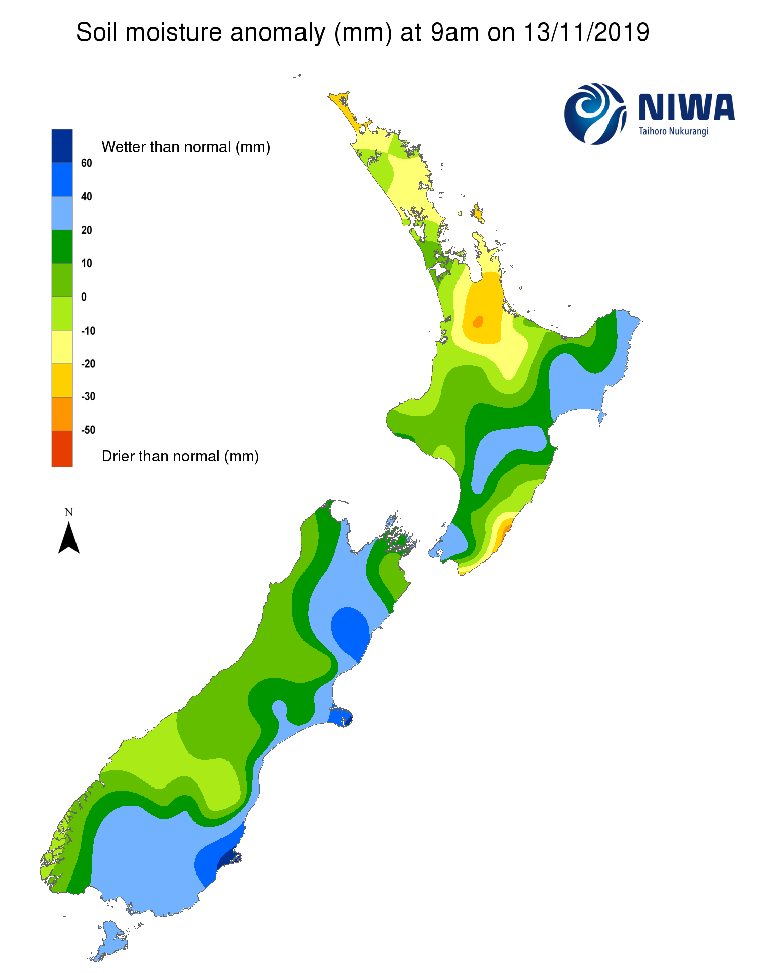
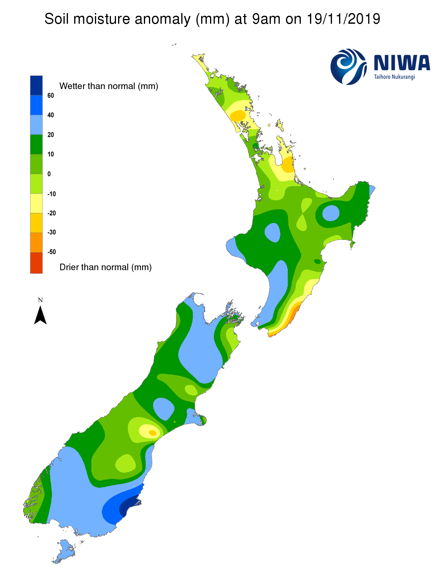
Soil Moisture Anomaly Maps, relative to this time of year. The maps show soil moisture anomaly for the past two weeks.
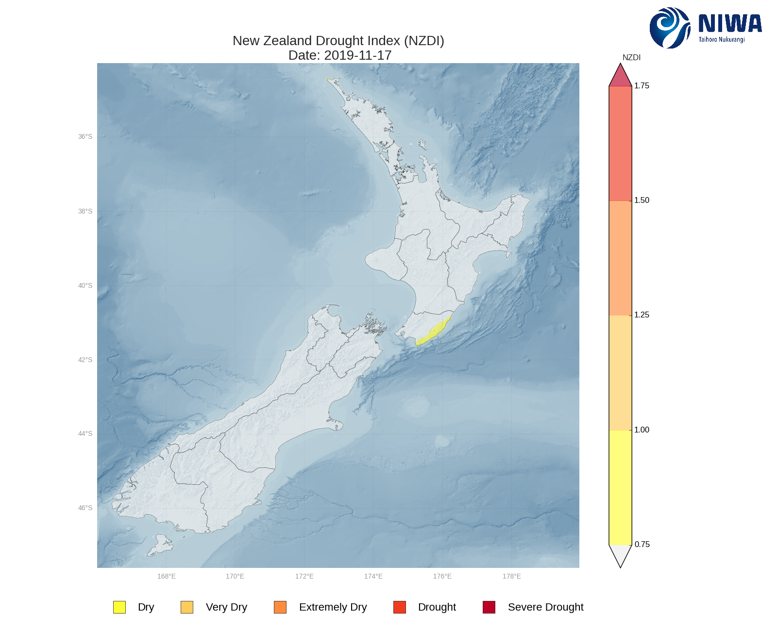
As of 17 November, the New Zealand Drought Index (NZDI) map below shows that drier than normal conditions are located across coastal Wairarapa, the area will likely continue to dry during the upcoming week. Please note: some hotspots in the text above may not correspond with the NZDI map, mainly because the NZDI uses additional dryness indices including one which integrates the rainfall deficit over the past 60 days. Changes are therefore slower to appear in the NZDI compared to the instantaneous status maps of soil moisture anomaly.