A weekly update describing soil moisture patterns across the country to show where dry to extremely dry conditions are occurring or imminent. Regions experiencing significant soil moisture deficits are deemed “hotspots”. Persistent hotspot regions have the potential to develop into drought.
Facts: Soil Moisture
In the North Island, the past week featured generally meagre rainfall, particularly in parts of Northland, Auckland, the Central Plateau, Wairarapa, and the western North Island, where rainfall totals were typically 5 mm or less, and some locations received no rainfall at all. Gisborne was an exception, where amounts of 25-50 mm were observed. Moderate rainfall also occurred in parts of the Coromandel and eastern Northland. This resulted in soil moisture decreases across a majority of the North Island, although soil moisture levels remain above to well above normal for most locations despite the recent dryness. The driest soils across the North Island, when compared to normal for this time of the year, are found in southern Manawatū-Whanganui, while the wettest soils for this time of the year are found in eastern Northland, Auckland, the Coromandel Peninsula, western Bay of Plenty, Gisborne, Hawke’s Bay, and Wairarapa.
A small hotspot has formed in the past week in far southern Manawatū-Whanganui.
In the South Island, parts of Buller, Grey, and northern Westland saw rainfall amounts of 30-60 mm during the past week. However, outside of these areas, rainfall totals were minimal. In fact, many locations in the upper, eastern, and lower South Island received no rainfall at all in the past week. This resulted in moderate soil moisture decreases for nearly the entire island. The driest soils in the South Island, when compared to normal for this time of the year, are located in the upper West Coast, Fiordland, coastal Southland, and Stewart Island, while the wettest soils for this time of the year are found in a small portion of Tasman and eastern Marlborough.
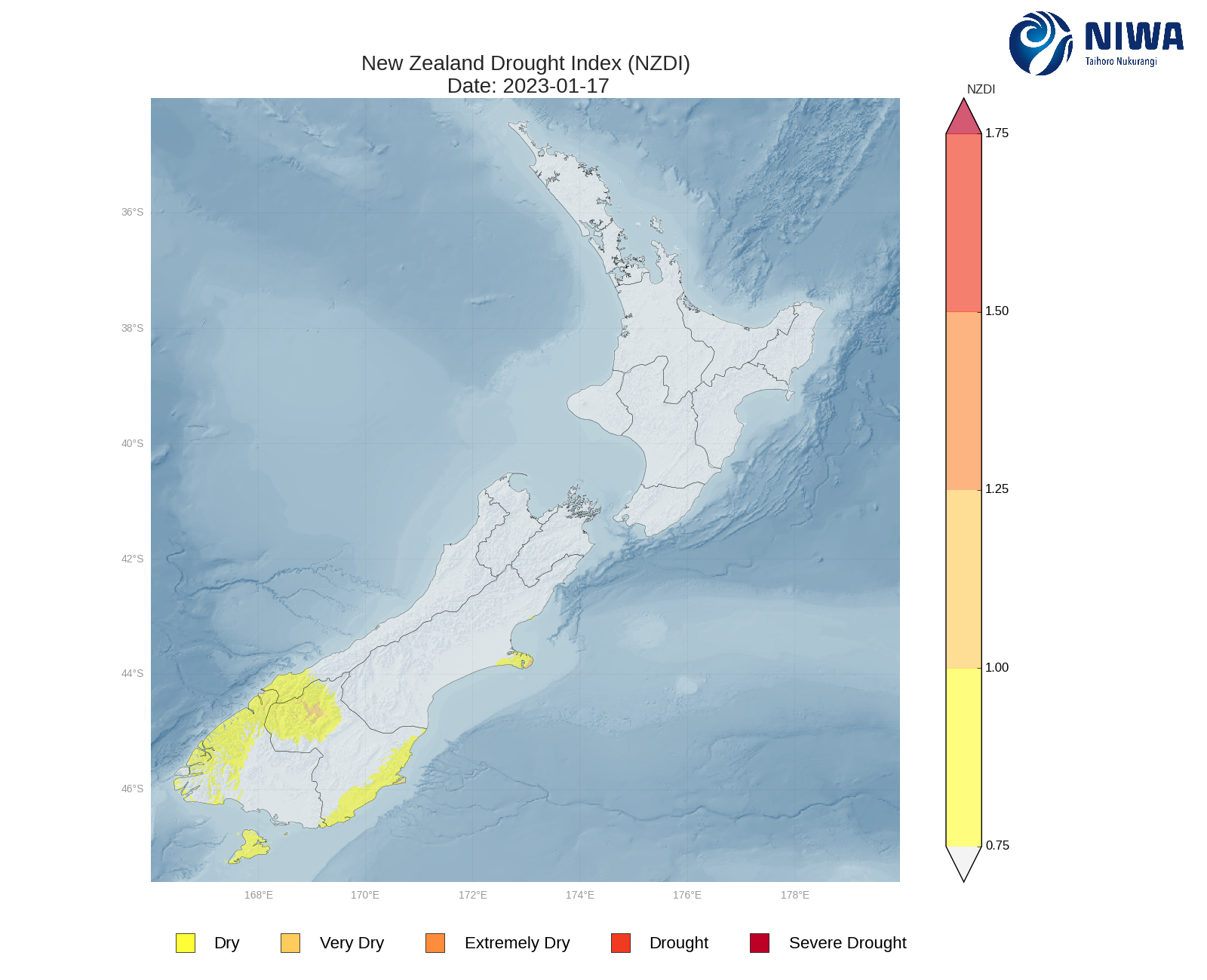
South Island hotspots are currently located in Banks Peninsula, much of Otago, and coastal Southland. As of 17 January, the New Zealand Drought Index (NZDI) map below shows that dry conditions are currently located in Banks Peninsula, coastal and interior Otago, the lower West Coast, Fiordland, and Stewart Island. In addition, eastern Banks Peninsula and a portion of interior Otago are experiencing very dry conditions.
Outlook and Soil Moisture
In the North Island, the next several days will feature high pressure nearby or overhead. This will continue to result in mostly dry weather over the next week or so. However, nearly every day is likely to feature scattered afternoon showers and perhaps isolated thunderstorms, typically in the Central Plateau. There is also a chance that by late next week (26-27 January), some subtropical moisture may reach the Far North. Weekly rainfall totals could reach 30-40 mm in localised parts of the Central Plateau where the heaviest showers and thunderstorms occur in the coming days, with a small chance for similar amounts in the Far North. Elsewhere, another week of minimal rainfall is likely.
Due to the expected rainfall in the next week, only small changes to soil moisture levels are likely in the Central Plateau and perhaps the Far North. However, notable decreases may occur in the rest of the North Island. The current hotspot in far southern Manawatū-Whanganui may strengthen and expand in the next week.
In the South Island, moderate rainfall is moving through the lower West Coast, Southland, and Otago today (20 January). The same areas may see additional light rainfall on Sunday (22 January). Otherwise, high pressure will bring dry weather for most of the next week or so, with only a handful of daily, light showers occurring. There is a possibility that slightly more organised rainfall may reach the West Coast by next Friday (27 January). Weekly rainfall totals may reach 40-50 mm in Fiordland and the lower West Coast, with 20-25 mm possible in the lower South Island. Elsewhere, many locations may only see weekly totals of 15 mm or less.
Due to the expected rainfall in the next week, soil moisture levels may decrease substantially in much of the South Island, although decreases may be smaller in parts of Otago and Southland. The current hotspot in Banks Peninsula will likely strengthen and expand in the next week, while those in the lower South Island may see smaller changes. Additionally, a new hotspot could form near Nelson in the next week.
Looking ahead to late January and early February, persistently low rainfall and above average temperatures could result in an escalation of the dryness about lower and western parts of the South Island.
For more information on the potential for dryness in the weeks to come, please check out the drought forecasting tool, a collaboration between NIWA and the Ministry for Primary Industries.
Background:
Hotspot Watch: a weekly advisory service for New Zealand media. It provides soil moisture and precipitation measurements around the country to help assess whether extremely dry conditions are imminent.
Soil moisture deficit: the amount of water needed to bring the soil moisture content back to field capacity, which is the maximum amount of water the soil can hold.
Soil moisture anomaly: the difference between the historical normal soil moisture deficit (or surplus) for a given time of year and actual soil moisture deficits.
Definitions: “Extremely” and “severely” dry soils are based on a combination of the current soil moisture status and the difference from normal soil moisture (see soil moisture maps)
Hotspot: A hotspot is declared if soils are "severely drier than normal" which occurs when Soil Moisture Deficit (SMD) is less than -110 mm AND the Soil Moisture Anomaly is less than -20 mm.
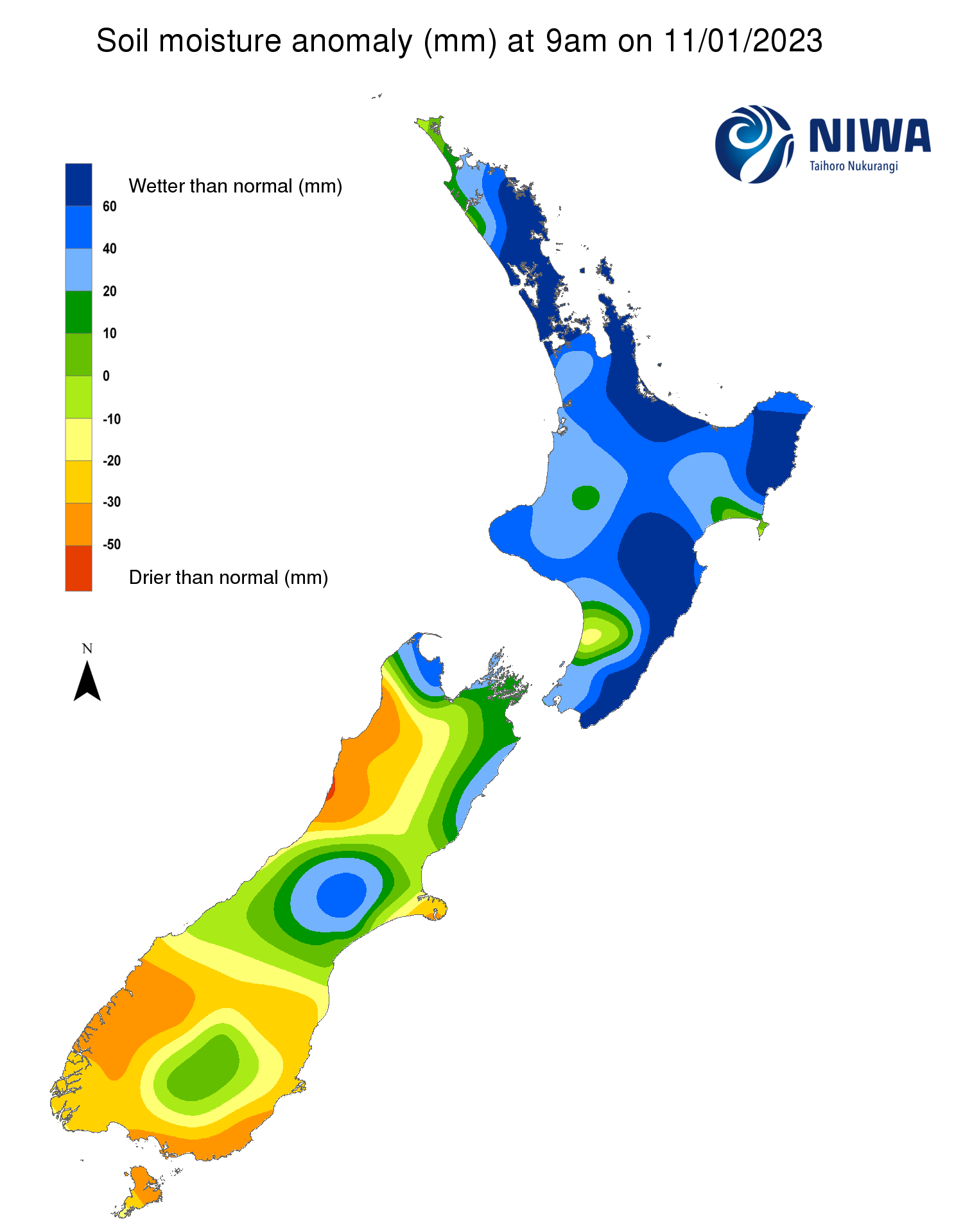
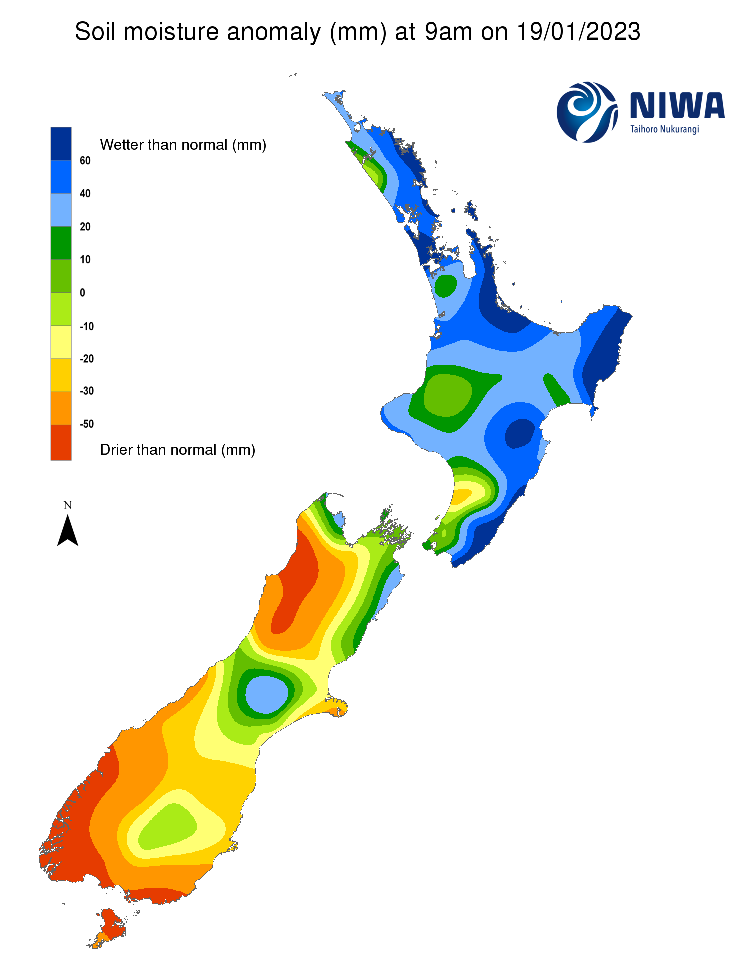
Pictured above: Soil Moisture Anomaly Maps, relative to this time of year. The maps show soil moisture anomalies over the past two weeks.
New Zealand Drought Index (NZDI)
As of 17 January, the New Zealand Drought Index (NZDI) map below shows that dry conditions are currently located in Banks Peninsula, coastal and interior Otago, the lower West Coast, Fiordland, and Stewart Island. In addition, eastern Banks Peninsula and a portion of interior Otago are experiencing very dry conditions. Please note: some hotspots in the text above may not correspond with the NZDI map. This difference exists because the NZDI uses additional dryness indices, including one which integrates the rainfall deficit over the past 60 days. Changes are therefore slower to appear in the NZDI compared to soil moisture anomaly maps that are instantaneously updated.