A weekly update describing soil moisture across the country to help assess whether severely to extremely dry conditions are occurring or imminent. Regions experiencing these soil moisture deficits are deemed “hotspots”. Persistent hotspot regions have the potential to develop into drought.
Facts: soil moisture
Across the North Island, moderate to large increases in soil moisture levels were observed in most locations due to substantial rainfall in the past week. The most significant increases occurred across Northland, Wellington, Gisborne, and eastern Bay of Plenty. Conversely, some soil moisture decrease was noted in northern Waikato and the Coromandel Peninsula. The driest soils across the North Island compared to normal for this time of the year are now found in coastal Wairarapa and parts of northern Waikato, while the wettest soils for this time of the year are located in Gisborne, Hawke’s Bay, and western Wellington.
In the North Island, previous hotspots located at the top of Aupouri Peninsula and in far southern Wairarapa have both weakened to below official hotspot criteria in the past week. Therefore, no hotspots are currently active in the North Island.
In the South Island, soil moisture levels increased everywhere during the past week, and significantly so in many places. The most substantial increases were observed across the northern half of the South Island along with interior southern Canterbury and Otago. The driest soils across the South Island compared to normal for this time of the year are found across interior Otago and southern Westland, while the wettest soils for this time of the year are found near Dunedin and on Banks Peninsula.
Due to the substantial increase in soil moisture levels observed in the past week, previous hotspots across interior southern Canterbury, the Queenstown-Lakes District, and the northeast coast of Marlborough have all dissipated. No hotspots are currently active in the South Island.
Outlook and soil moisture
In the North Island, several fronts moving up from the southwest will bring rainfall during the upcoming week. The first will primarily affect western areas late Thursday to early Friday, with amounts of 5-15 mm possible. Isolated showers may occur during the upcoming weekend (16-17 November), but rainfall amounts would be light. A more substantial front will bring moderate rainfall and possibly isolated thunderstorms on Monday. After dry weather on Tuesday, another front on Wednesday (20 November) will produce additional rain and scattered thunderstorms. Total weekly rainfall in western areas and the Central Plateau may exceed 50 mm, while much of the remainder of the North Island will receive 20-40 mm. However, rainfall amounts are likely to be lower in much of the East Coast, where 5-15 mm may fall.
In much of the North Island, soil moisture levels will likely stay constant or increase during the upcoming week due to moderate rainfall amounts. The primary exception will be the central and northern East Coast, where lesser rainfall amounts will lead to some soil moisture decreases. Despite this, no hotspots are expected to emerge in the North Island in the next week.
In the South Island, a series of fronts will arrive in the next week, bringing large amounts of rainfall to the West Coast and generally moderate amounts elsewhere. During the upcoming weekend (16-17 November) the lower South Island will receive 15-25 mm of rain, with lesser amounts across northern Canterbury and Marlborough. After drier weather early next week, a developing area of low pressure will bring more rainfall by late Tuesday and Wednesday (19-20 November). Total weekly rainfall is expected to reach 15-25 mm in Marlborough and northern Canterbury, but in the lower South Island, more substantial amounts of 30-50 mm are likely. Meanwhile, on the West Coast rainfall amounts could exceed 200 mm.
Soil moisture levels are likely to increase more along the West Coast and in parts of the lower South Island during the next week, while most other areas will see little change. However, a few areas in northern Canterbury and Marlborough may see slight soil moisture decreases due to lighter rainfall amounts. No hotspots are expected to re-emerge across the South Island during the next week.
Background
Hotspot Watch: a weekly advisory service for New Zealand media. It provides soil moisture and precipitation measurements around the country to help assess whether extremely dry conditions are imminent.
Soil moisture deficit: the amount of water needed to bring the soil moisture content back to field capacity, which is the maximum amount of water the soil can hold.
Soil moisture anomaly: the difference between the historical normal soil moisture deficit (or surplus) for a given time of year and actual soil moisture deficits.
Definitions: “Extremely” and “severely” dry soils are based on a combination of the current soil moisture status and the difference from normal soil moisture (see soil moisture maps)
Hotspot: A hotspot is declared if soils are "severely drier than normal" which occurs when Soil Moisture Deficit (SMD) is less than -110 mm AND the Soil Moisture Anomaly is less than -20 mm.
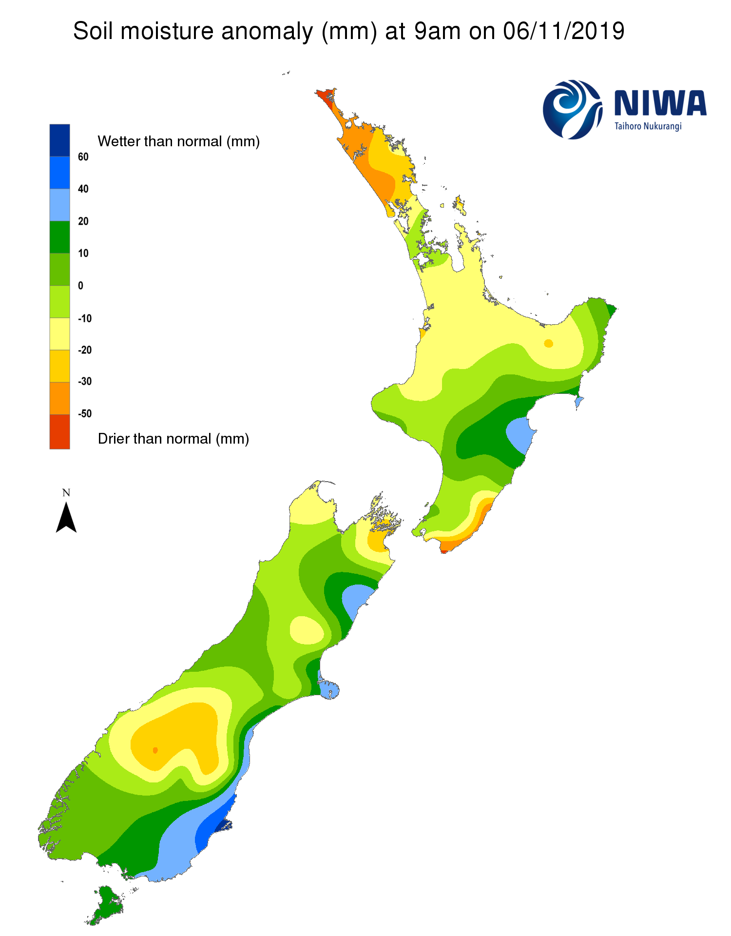
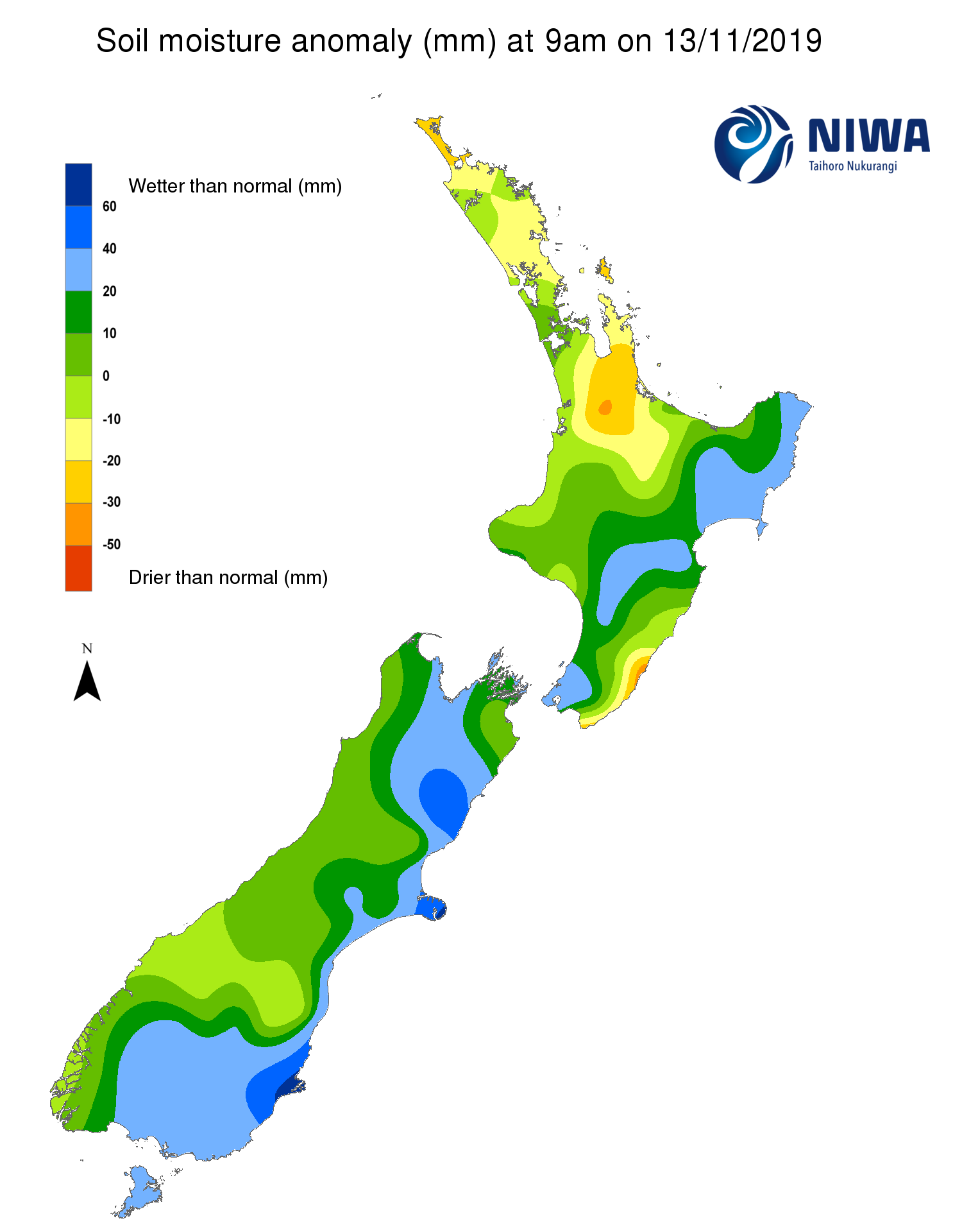
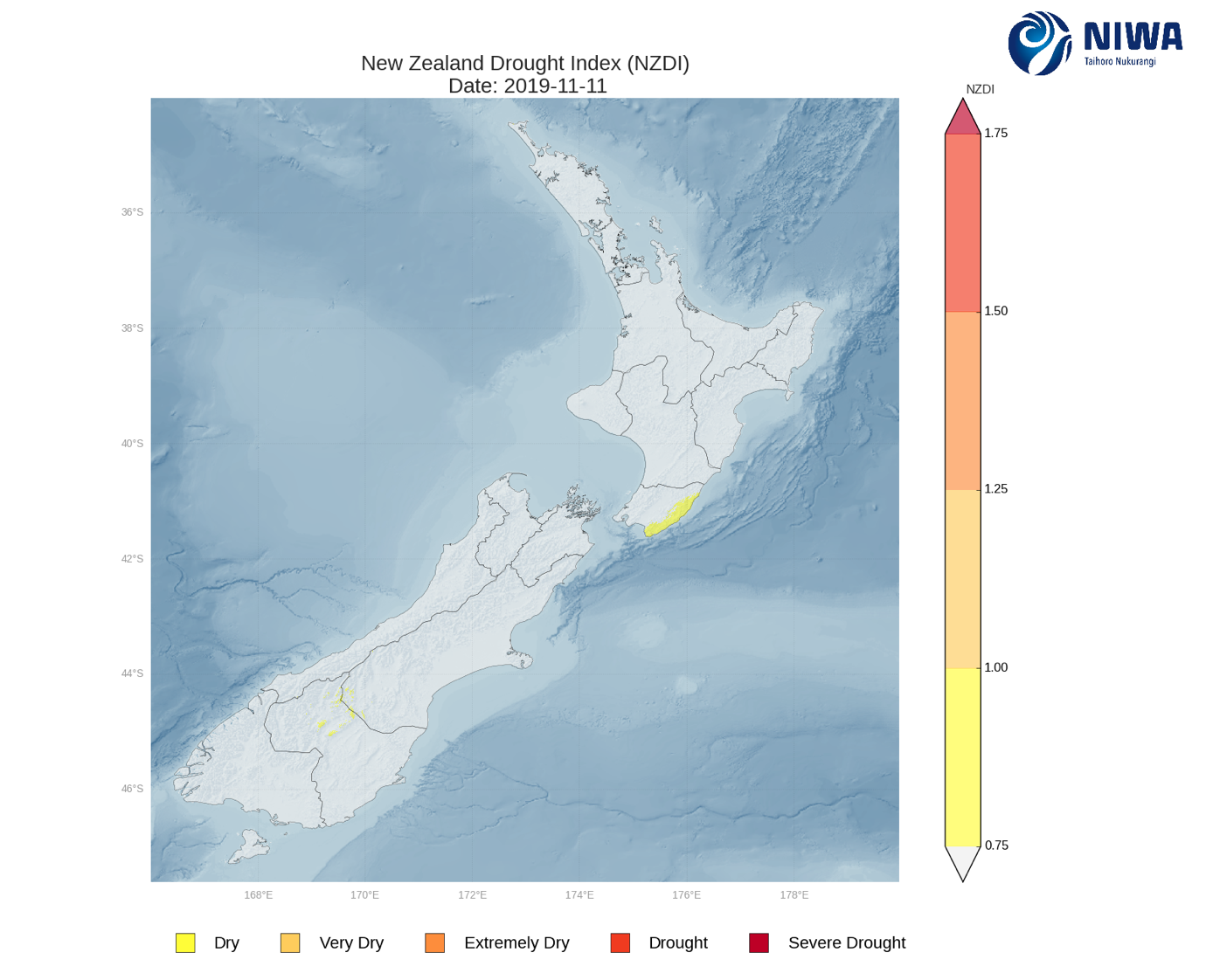
Soil Moisture Anomaly Maps, relative to this time of year. The maps show soil moisture anomaly for the past two weeks. As of 11 November, the New Zealand Drought Index (NZDI) map below shows that drier than normal conditions are located across coastal Wairarapa, but the dry area in interior Otago has improved markedly in the past week. The dry area in Wairarapa will likely not change significantly in the coming week, but continued improvement may be seen in Otago. Please note: some hotspots in the text above may not correspond with the NZDI map, mainly because the NZDI uses additional dryness indices including one which integrates the rainfall deficit over the past 60 days. Changes are therefore slower to appear in the NZDI compared to the instantaneous status maps of soil moisture anomaly.