The issue
The alp-fed braided rivers of Canterbury are treasured for their landscape, recreational amenities, salmon- and trout-fishing, and unique riverine environments – which provide habitat to a host of endangered birds (e.g., Black-billed Gull, Wrybill) – but they are under threat from land-use intensification and a growing demand for irrigation water. With river baseflow and groundwater resources fully allocated (and controlled by minimum flow rules) in most catchments, the only remaining “free” water is that which gushes to the sea during floods and freshes – thus floodwater “harvesting” into large off-river storage ponds, for regulated release into irrigation networks, is an expanding activity.
Flood harvesting isn't necssarily free of environmental effects, several reasons why are outline below.
Flood flows serve the very useful function of transporting the braided rivers’ gravelly bedload to the coast. Even a proportionally small take of flood water can alter the balance between bedload supply and transport capacity, which, over time, can induce a long-term change in braided river bed morphology – the expectations are a fining of the riverbed surface material, reduction in channel relief, and ultimately – if the take is large - riverbed aggradation. Floods also naturally help control riverbed woody vegetation and weeds, which, if left unchecked, can begin to take control of the river morphology. Such geomorphic responses can change the physical habitat template (velocity, depth, substrate) with consequent effects on braided river biota.
Flood harvesting on the recessions of floods and freshes has the potential to increase the transient deposition of fine sediment (silt and sand) in lower-energy braided riverbed aquatic environments such as pools, littoral zones, and backwaters – notably in side-braids, which were once large main braids but have had their inflows reduced by upstream channel shifts. Such deposition has consequent effects on the river biota and users (e.g. binding spawning gravels, burying invertebrates, slipping fishermen). This occurs because downstream of the water take point, the reduced river flow still carries the same concentration of suspended load but there are more low-energy environments to trap it.
Freshes and floods keep braided river mouths (called hapua) open against the effect of storm waves. If the floods at the river mouth have reduced frequency or magnitude, the river’s ability to keep its mouth open may be diminished, and – at least in smaller rivers – periods of mouth closure may persist, which has implications for the hapua ecosystems and fish migration to/from the sea.
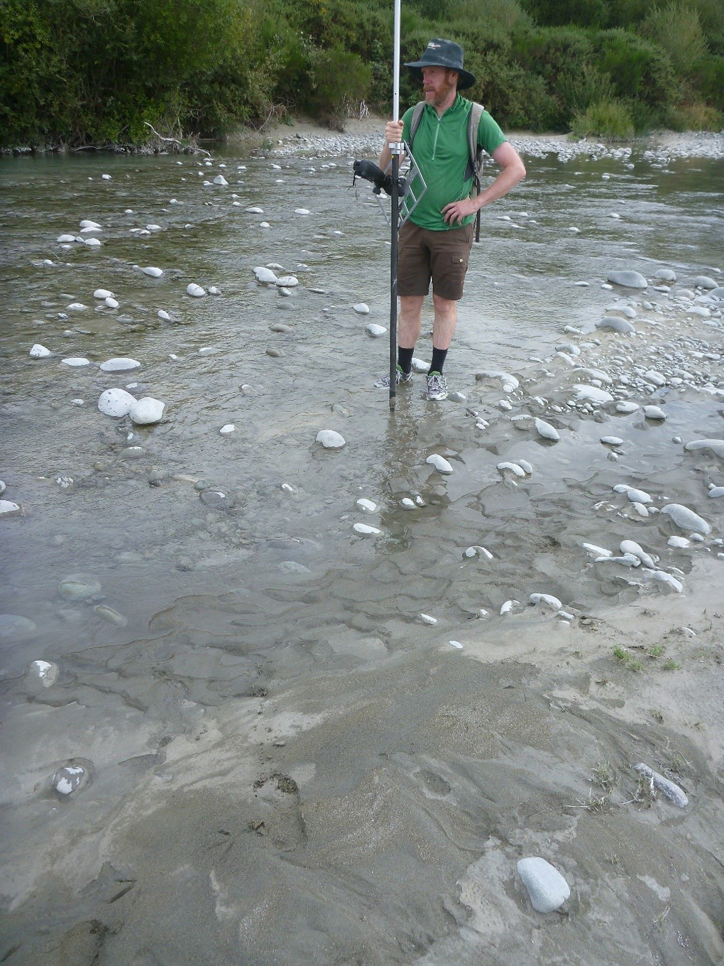
Silty-sand draping the cobbly substrate of a shallow side-braid on the Rangitata River. Such environments are prone to fine sediment deposition when flows recede while still carrying a suspended load. Photo: Jo Hoyle.
The approach
The Sediment Processes Group in Christchurch has commenced research within the eFlows Program with the ultimate aim of being able to quantitatively predict the effects on braided river geomorphology and associated values of a flood harvesting scheme and suggesting limits and/or mitigating conditions. The research has three threads, addressing the issues listed above:
- Quantifying morphological change in flood-harvested braided rivers by repeating morphological surveys done in the early 2000s, then exploring these changes for impacts on physical habitat, navigability, etc, with the use of 2d hydraulic models. The ultimate aim is to be able to simulate the morphological change from flood harvesting using numerical “morphodynamic” models (as we have done with riverbed vegetation effects, e.g., https://www.youtube.com/watch?v=apBMr7blbv8).
- Using a numerical model (DELFT3D) to simulate fine sediment deposition and re-entrainment in a braided river reach. The aim is to verify the model by surveying riverbed fine sediment cover (photo above) and measuring the fine sediment supply from upstream, then re-running the model with a range of flood-harvesting scenarios.
- A new, hybrid river/coastal morphodynamic model is being built to simulate braided river mouth behaviour in response to changes in river flow.
Early results
Early results from the fine sediment deposition research thread have highlighted the potential natural vulnerability of braided rivers such as the Rangitata, which has abundant fine sediment sources in its headwaters. These headwater sources result in a relatively long travel time for sediment to reach the Canterbury Plains, where existing flood harvesting occurs. Moreover, significant sediment sources include small lakes at the toes of melting glaciers. These lakes discharge turbid water well down event recessions.
The graph below shows the records of flow and turbidity (which provides a proxy measure of the concentration of the river’s suspended sediment load) from the Rangitata River at the top of the Canterbury Plains through an example runoff event. The turbidity on the event recession is several times higher than at equivalent flows during the event’s rising stages – signaling a delayed supply of sediment – which concurs with the observations above about headwater sediment sources. Elevated suspended sediment concentrations late in events are typical for the Rangitata and make this river naturally vulnerable to fine sediment deposition. Moreover, by removing water from the river but leaving the same sediment concentration in the residual flow, flood harvesting will encourage this deposition.
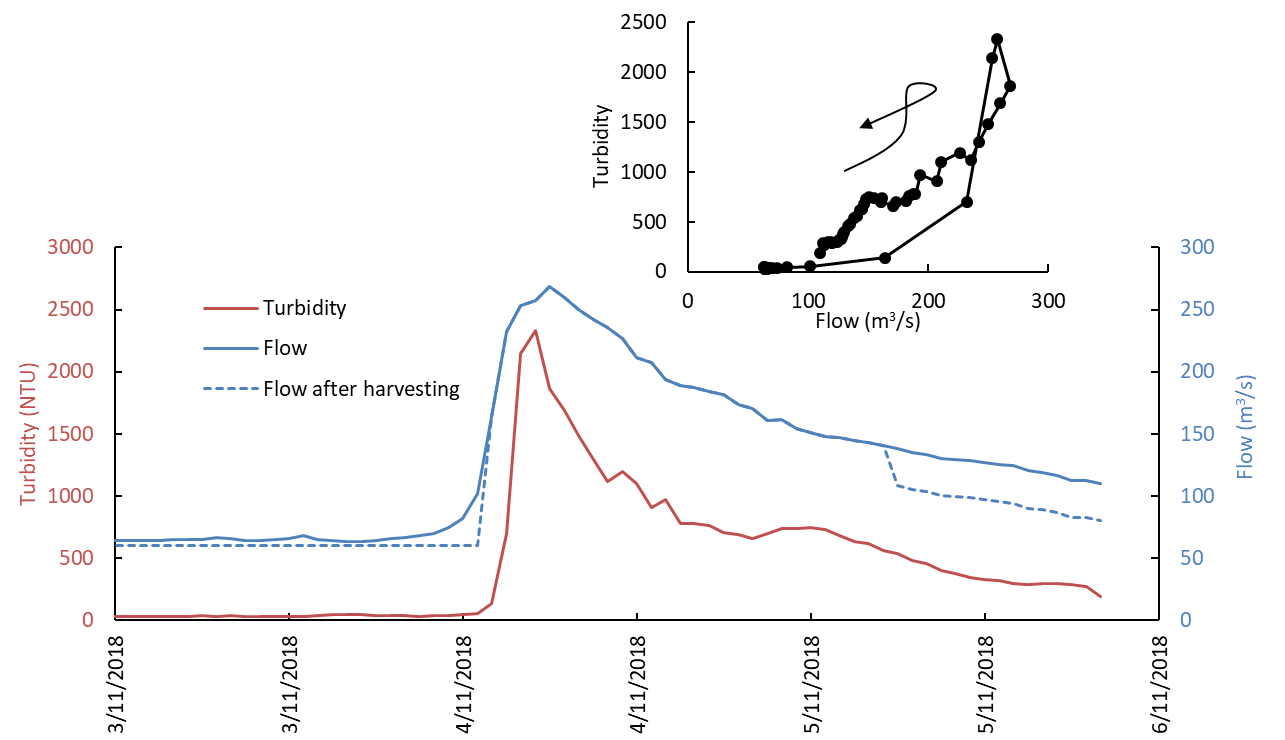
Figure 4: Flow (blue) and turbidity (red) records over a “fresh” on the Rangitata River. Dashed blue line plots flow downstream of water intake (based on hypothetical extraction rules that harvest below 150 m3/s but not below 60 m3/s). Inset plot shows turbidity-flow relationship during event. Arrow shows time-sequence of data. Note considerably higher turbidity (at a given flow) on event recession. Flows in river after water harvesting have turbidity values substantially higher than the turbidity values at the same flows on the natural recession (e.g., in the example shown, at 110 m3/s on the natural recession the turbidity is ~200 NTU, but after flood harvesting at 110 m3/s the turbidity is ~600 NTU). Flow data is from Environment Canterbury’s Klondyke flow recorder. Turbidity data is from RDRML and is measured in the upstream part of the RDR, a large water supply canal that abstracts water under gravity from the Rangitata. Turbidity measured in the RDR is a useful analogue for turbidity in the river.
Reference
Hicks, M. (2018) Statement of evidence of Darryl Murray Hicks before Canterbury Regional Council in the matter of the Resource Management Act 1991 and in the matter of the Rangitata Diversion Race Consents, including effects of flood harvesting on bedload transport and channel morphology in the Rangitata River, 30 March 2018.