Tropical moisture brings prolific rainfall to the North Island and eastern South Island.
|
Rainfall
|
Prolific rainfall totals were observed across nearly the entire North Island, with more than twice the normal April rainfall (>200%) recorded in the large majority of locations. Amounts exceeding three times the April normal (>300%) were also observed in several places. In the North Island, only northern and western Northland received near normal rainfall (80-119% of normal). The northern and eastern South Island also received widespread rainfall in excess of 200% of the April normal, with a couple of locations picking up more than 300% of normal April rainfall. Conversely, much of the West Coast saw near normal (80-119% of normal) to above normal (120-149% of normal) rainfall. Meanwhile, much of Southland and Queenstown-Lakes received below normal rainfall (50-79% of April normal). |
|
Temperature |
The majority of the North Island experienced well above average (>1.20°C above average) or above average (0.51 to 1.20°C above average) temperatures in April. Isolated locations in the central and southern North Island, as well as the northern and eastern South Island, recorded near average (-0.50 to 0.50°C of average) temperatures. Temperatures were primarily well above average (>1.20°C above average) or above average (0.51 to 1.20°C above average) in the western and southern South Island. |
|
Soil Moisture |
As of 1 May 2017, soils across most of the North Island were much wetter than normal for the time of year. In the South Island, soils were much wetter than normal in most of the north and east. However, much drier than normal soils were located across Queenstown-Lakes District and much of Southland. |
|
Sunshine |
Near normal (90-109% of normal) to below normal (75-89% of normal) sunshine hours were recorded for most locations around New Zealand, while isolated areas of well below normal (<75% of normal) sunshine were observed in the lower North Island and in Central Otago. Isolated above normal (110-125% of normal) sunshine was recorded in the western North Island. |
Overview
April 2017 was characterised by higher than normal atmospheric pressure to the south and southeast of the South Island, along with lower than normal atmospheric pressure over and to the north of the North Island. This pressure pattern resulted in more northeasterly wind flow than normal, bringing with it moist tropical air masses and record-high rainfall for parts of the North Island. These tropical air masses also delivered very warm temperatures to much of the North Island. This pattern also led to a very wet month for the northern and eastern South Island, but at the same time sheltering the West Coast and far south with drier conditions and warm temperatures for the time of year.
Widespread heavy rainfall was the flavour of the month for the majority of the North Island along with the north and east of the South Island. Most locations received the bulk of their April rainfall during two distinct events; the passage of the remnants of Cyclone Debbie during 4-5 April and the arrival of ex-Cyclone Cook during 12-13 April. These storms both brought heavy rain and flooding to much of the North Island and parts of the South Island. Cook also brought high winds to the eastern North Island, resulting in downed trees and power outages. The impacts of these significant rainfall events are covered in more detail in the Highlights and Extreme Events section.
Nearly the entire North Island along with the northern and eastern South Island received significant amounts of rain in April. In these regions, more than double the normal rainfall for April (>200% of April normal) was widespread, with some locations receiving more than three times (>300%) their normal rainfall for the month. Notably, Whangaparaoa (north of Auckland) received an incredible 452% of normal April rainfall (319 mm). A multitude of locations around the country either broke or nearly broke rainfall records for April (see Rainfall section on Page 4). In the North Island, only northern and western Northland did not receive well above normal rainfall. There, amounts were near normal (80-119% of normal). In the South Island, the West Coast saw near normal (80-119% of normal) to above normal (120-149% of normal) rainfall. The heavy rainfall in the north and east of the South Island was due to the predominant northeasterly airflow during the month, along with the heavy rainfall from Cook tracking right along the east coast. Conversely, high pressure and the blocking of moist air by mountain ranges led to below normal rainfall (50-79% of April normal) for Queenstown-Lakes District and much of Southland.
With north-northeasterly winds and tropical air masses moving across the North Island, temperatures were well above average (>1.20°C above average) or above average (0.51 to 1.20°C above average) across most of the Island in April. In fact, at 2.3 °C above average, Te Puke had its warmest April since records began there in 1973. Across the whole North Island, only a few locations in Waikato and Wellington had near average (-0.50 to 0.50°C of average) temperatures. Locations in the northern and eastern South Island generally recorded near average (-0.50 to 0.50°C of average) temperatures in April, while temperatures were primarily well above average (>1.20°C above average) or above average (0.51 to 1.20°C above average) along the West Coast and in Otago and Southland. This temperature division across the South Island was primarily due to northeasterly airflows warming as they travelled down the western (lee) side of the mountain ranges, in a phenomenon known as the foehn effect. The nationwide average temperature in April 2017 was 14.0°C (0.7°C above the 1981-2010 April average from NIWA’s seven station temperature series which begins in 1909).
Soil moisture levels across New Zealand at the end of April generally reflected the rainfall pattern seen during the month. Soils across most of the North Island were much wetter than normal for the time of year, with slightly wetter than normal soils in parts of the central and northeastern North Island. In the South Island, soils were much wetter than normal in most of the north and east. However, much drier than normal soils were located across Queenstown-Lakes and much of Southland, while soil moisture was generally near normal along much of the West Coast.
Sunshine was generally near normal (90-109% of normal) to below normal (75-89% of normal) for most locations around New Zealand, consistent with moist air masses that brought cloudy and rainy conditions to much of the country. However, onshore northeasterly airflows also produced isolated areas of well below normal (<75% of normal) sunshine in the Wellington region and also Central Otago. Isolated above normal (110-125% of normal) sunshine was recorded in the western North Island.
Further highlights
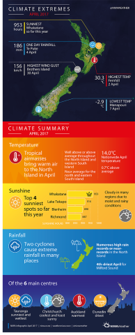
- The highest temperature was 30.3°C, observed at Fernhill (Hawke’s Bay) on 2 April.
- The lowest temperature was -2.9°C, observed at Manapouri on 7 April.
- The highest 1-day rainfall was 186.0 mm, recorded at Te Puke on 4 April.
- The highest wind gust was 156 km/hr, observed at Brothers Island (Cook Strait) on 30 April.
- Of the six main centres in April 2017, Tauranga was the wettest and sunniest, Christchurch was the coolest and least sunny, Auckland was the warmest, and Dunedin was the driest.
- Of the available, regularly reporting sunshine observation sites, the sunniest four locations in 2017 (1 January – 30 April) were Whakatane (953.3 hours), Lake Tekapo (916.1 hours), Blenheim (898.2 hours) and Richmond (886.9 hours).
Download
Monthly climate summary for April 2017 [PDF 200KB]
Monthly climate statistics for April 2017 [PDF 69KB]
Contacts
For further information, please contact:
Mr Chris Brandolino, Principal Scientist – Forecasting, NIWA National Climate Centre Tel. 09 375 6335