Tropical cyclone outlook summary for the Pacific Islands
- The NIWA and MetService assessment of tropical cyclone (TC) activity for the coming season indicates normal to above normal activity. [Tropical cyclones are categorised in strength from 1 to 5, with 5 being most intense. Tropical cyclones that reach category 3 or higher are classified as severe, with mean (10 minute) wind speeds of at least 119 km/h.]
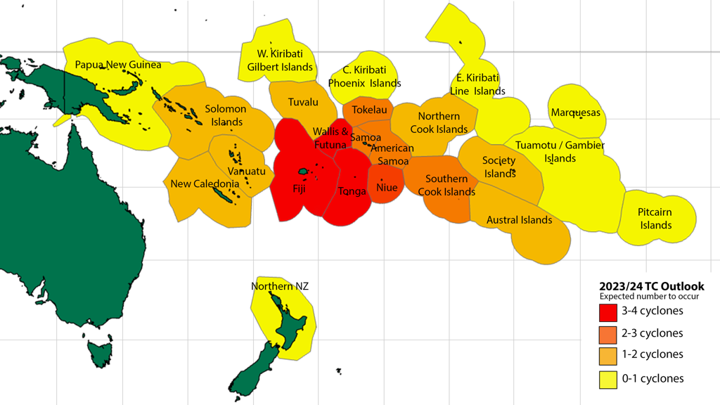
- 9 to 14 named TCs could occur in the Southwest Pacific from November 2023-April 2024.
- TCs have a significant impact across the Southwest Pacific, with the season starting in November and lasting through April. For the coming season, significant differences are expected between the western and eastern halves of the basin.
- The risk of impact from a TC is expected to be higher around and to the east of the International Date Line, as illustrated below, and in a band across the tropics associated with a more northward displaced South Pacific Convergence Zone.
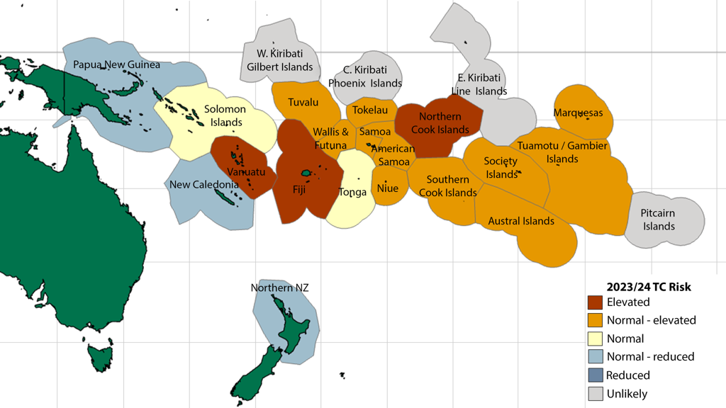
- Vanuatu and New Caledonia typically experience the greatest TC activity with an average of two or three named TCs passing nearby each year.
- Elevated activity: Vanuatu, Fiji and the Northern Cook Islands.
- Normal or elevated activity: Wallis & Futuna, Tuvalu, Tokelau, Niue, Samoa, American Samoa, Austral Islands, Southern Cook Islands, Society Islands, Tuamotu Archipelago and Marquesas.
- Near normal activity: Solomon Islands and Tonga.
- Normal or reduced activity: Papua New Guinea, New Caledonia and Northern New Zealand.
- Between 4-8 severe TCs reaching category 3 or higher may occur anywhere across the region, so all communities should remain prepared.
- Past seasons with similar conditions to the present, called “analogue years”, suggest multiple TCs could intensify to at least category 3 strength.
- Category 5 strength TCs, in which sustained winds exceed 199 km/h, are associated with a majority of the analogue years. [Since quality observations began in the early 1970s, there has been a trend toward fewer but stronger TCs.]
- Despite the official season running from November through April, TCs sometimes occur out-of-season.
- It does not take a direct hit or severe TC to cause considerable damage or life-threatening weather. When dangerous weather is forecast, please heed the advice of your local meteorological service, civil defence, or disaster management office.
Tropical cyclone outlook summary for New Zealand
- On average, at least one ex-TC passes within 550 km of New Zealand each year. This season, the risk is considered normal-reduced.
- If an ex-TC tracks close to the country, there is a near-equal probability of it tracking to the east or west of the North Island.
- Two out of five analogue years considered in this outlook had at least one ex-TC passing within 550 km of the country.
- Analogue years suggest that a decaying ex-TC entering the New Zealand region could affect maritime and coastal areas around the North Island, but an interaction with the South Island cannot be ruled out.
- Significant rainfall, extreme winds, hazardous marine conditions and coastal damage are all possible leading up to and during ex-TC events.
- The effects of ex-TCs can also be spread over a large area, particularly if the decaying ex-TC interacts with mid-to-high latitude weather systems.
El Niño-Southern Oscillation outlook
- The El Niño Southern Oscillation (ENSO), comprised of La Niña, neutral, and El Niño phases, plays an important role in year-to-year regional TC development and spatial coverage and is a key factor in this outlook.
- As of early October 2023, sea surface temperatures across the eastern and central equatorial Pacific Ocean are above average and exceed El Niño thresholds.
- Atmospheric circulation patterns related to ENSO over French Polynesia and northern Australia indicate well-coupled El Niño conditions at present.
- Oceanic and atmospheric forecasts for ENSO suggest El Niño, of moderate or strong intensity, has an 95% of continuing through December 2023 and that El Niño conditions are highly likely to persist (75% chance) through the back half of the TC season in February-April.
- The progress of ENSO and TC activity will continue to be tracked with an update to this guidance in January 2024 if needed.
For comment, please contact:
Mr Ben Noll, Meteorologist, NIWA
Mr Chris Brandolino, Principal Scientist – Forecasting and Media, NIWA
Mr Chris Noble, Senior Meteorologist, MetService Tel 027 470 0806
In the Pacific Islands, please contact your local national meteorological service for information about how this guidance should be interpreted. In Australia and the associated offshore islands, please contact the Australian Bureau of Meteorology. In French Polynesia, Wallis & Futuna, and New Caledonia please contact Météo-France.
For the latest issue of the tropical cyclone outlook and a video presentation discussing expected regional tropical cyclone activity, head to https://niwa.co.nz/climate/southwest-pacific-tropical-cyclone-outlook.
Download
Southwest Pacific Tropical Cyclone Outlook - summary and background [PDF 2MB]