Outlook Summary
- El Niño Alert criteria was reached during June. Central equatorial Pacific sea surface temperatures (SSTs) exceeded El Niño thresholds, but the Southern Oscillation Index (an atmospheric indicator) was neutral. The ocean-atmosphere system is expected to progress toward El Niño conditions from late winter into spring.
- With a developing El Niño, air pressure is forecast to be above normal over the Tasman Sea, leading to more southwesterly quarter winds than normal across the country for the season as a whole. Episodic easterlies are also possible, particularly early in the three month period, owing to a La Niña-like lag effect in the atmosphere.
- Seasonal wind strength may be above normal, particularly around the start of spring.
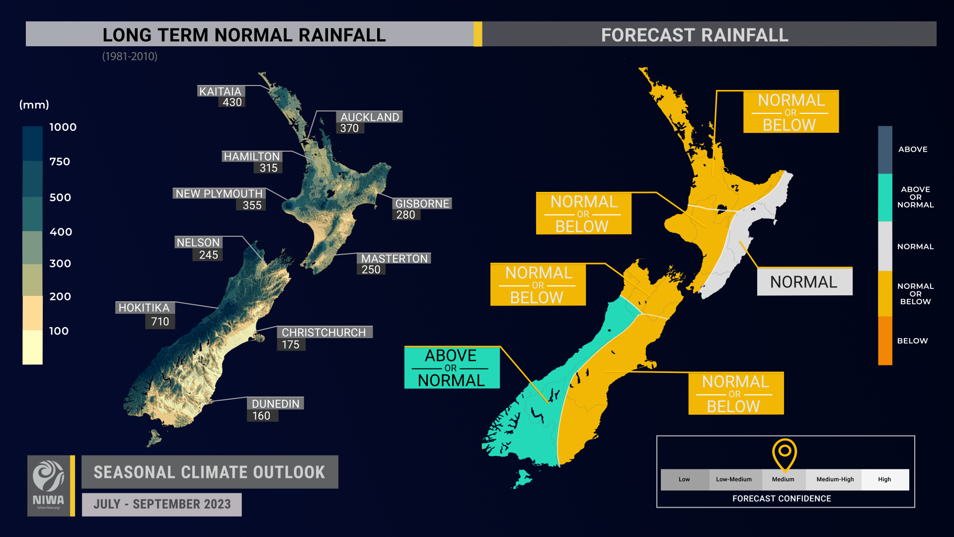
- Rainfall is most likely to be near normal in the east of the North Island, about equally likely to be near normal or above normal in the west of the South Island, and about equally likely to be near normal or below normal in all other regions.
- The developing El Niño is expected to result in a lower likelihood of tropical moisture plumes, such as those that frequently affected the country during the first half of this year.
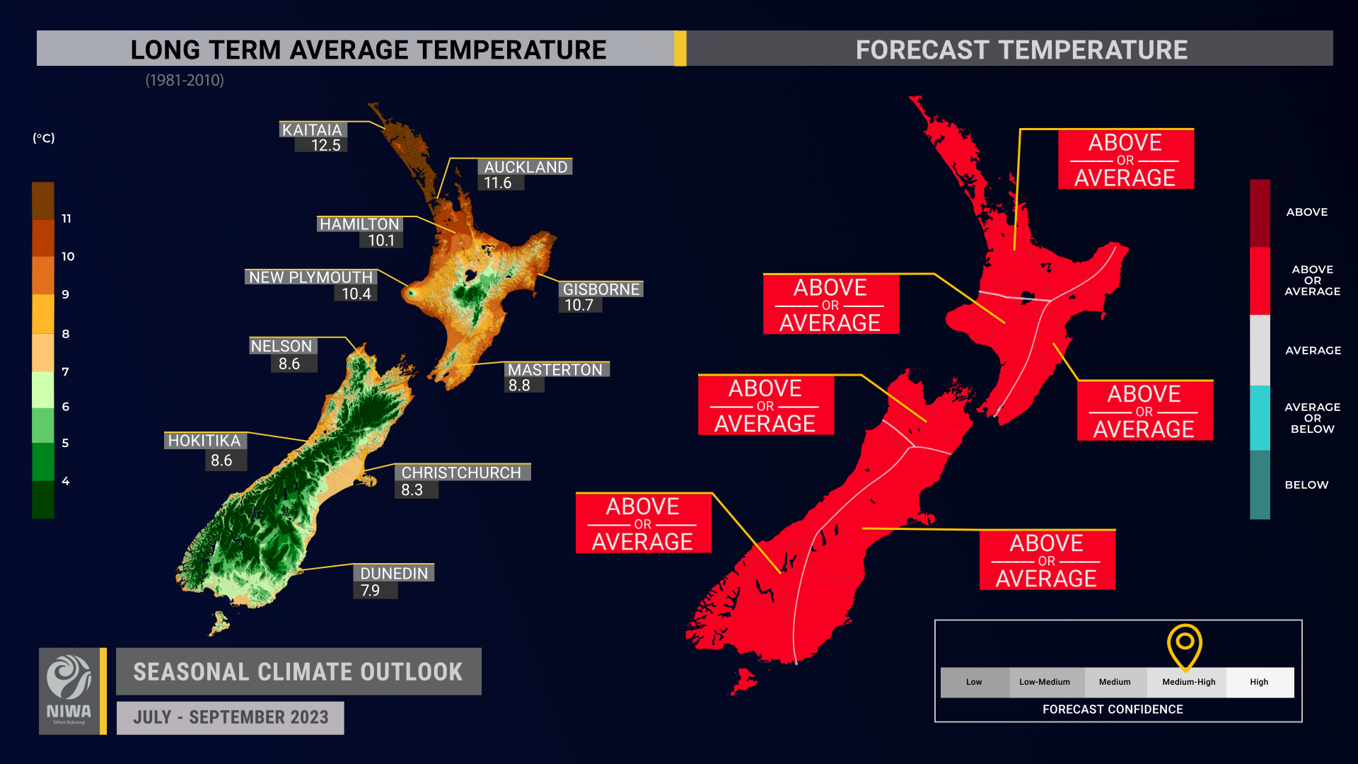
- Temperatures are about equally likely to be near average or above average in all regions. The potential easing of above average SSTs and a reduction in northerly air flows are expected to make for a season that has less frequent spells of above average temperatures.
- Short-but-sharp cold snaps are also likely, such as what’s expected in early July.
- Coastal sea surface temperatures (SSTs) ranged from 0.4˚C to 1.8˚C above average during June. The warmer than average seas may reduce the intensity of cold, southerly air masses.
- Soil moisture levels are most likely to be near normal in all regions. River flows are most likely to be near normal in the east of the North Island, about equally likely to be near normal or above normal in the west of the South Island, and equally likely to be near normal or below normal in all other regions.
Regional predictions for July – September 2023
Northland, Auckland, Waikato, Bay of Plenty
The table below shows the probabilities (or percent chances) for each of three categories: above average, near average, and below average. In the absence of any forecast guidance there would be an equal likelihood (33% chance) of the outcome being in any one of the three categories. Forecast information from local and global guidance models is used to indicate the deviation from equal chance that is expected for the coming three-month period. The following outcomes are the most likely for this region:
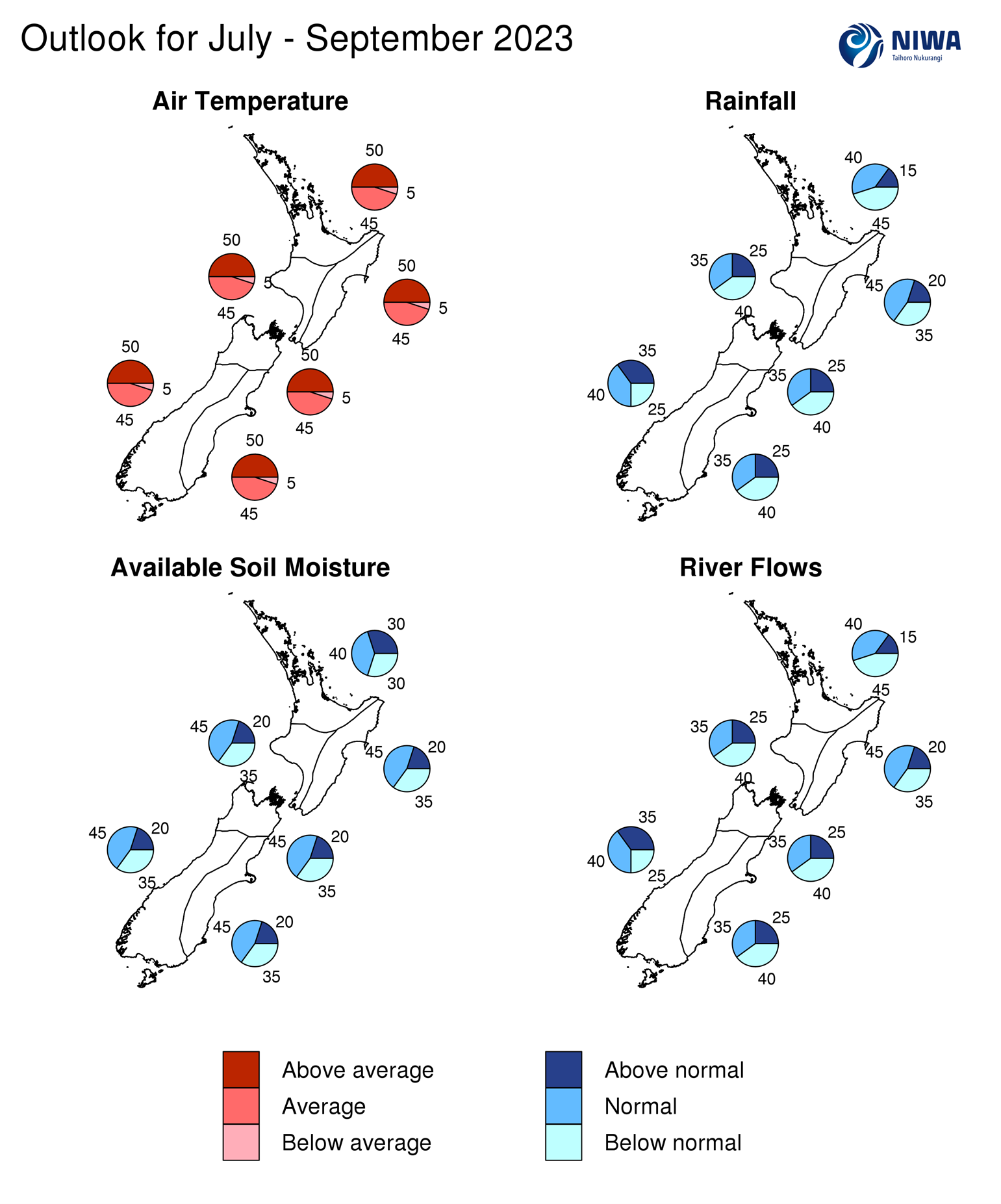
- Temperatures are about equally likely to be above average (50% chance) or near average (45% chance).
- Rainfall totals are about equally likely to be below normal (45% chance) or near normal (40% chance). Higher than normal air pressure may build across the Tasman Sea from time to time, leading to spells of drier than normal weather.
- Soil moisture levels are most likely to be near normal (40% chance) while river flows are about equally likely to be below normal (45% chance) or near normal (40% chance).
|
Temperature |
Rainfall |
Soil moisture |
River flows |
|
|
Above average |
50 |
15 |
30 |
15 |
|
Near average |
45 |
40 |
40 |
40 |
|
Below average |
05 |
45 |
30 |
45 |
Central North Island, Taranaki, Whanganui, Manawatu, Wellington
Probabilities are assigned in three categories: above average, near average, and below average.
- Temperatures are about equally likely to be above average (50% chance) or near average (45% chance). Marine heatwave conditions remain present in coastal waters. The warmer than average seas may reduce the intensity of cold, southerly air masses.
- Rainfall totals are about equally likely to be below normal (40% chance) or near normal (35% chance). Higher than normal air pressure may build across the Tasman Sea from time to time, leading to spells of drier than normal weather.
- Winds may be stronger than normal, especially around the start of spring.
- Soil moisture levels are most likely to be near normal (45% chance) while river flows are about equally likely to be below normal (40% chance) or near normal (35% chance).
|
Temperature |
Rainfall |
Soil moisture |
River flows |
|
|
Above average |
50 |
25 |
20 |
25 |
|
Near average |
45 |
35 |
45 |
35 |
|
Below average |
05 |
40 |
35 |
40 |
Gisborne, Hawke’s Bay, Wairarapa
Probabilities are assigned in three categories: above average, near average, and below average.
- Temperatures are about equally likely to be above average (50% chance) or near average (45% chance).
- Rainfall totals are most likely to be near normal (45% chance).
- The developing El Niño is expected to result in a lower likelihood of tropical moisture plumes; however, the atmosphere may still exhibit La Niña-like tendencies at times, occasionally increasing the chance for heavy rain.
- Winds may be stronger than normal, especially around the start of spring.
- Soil moisture levels and river flows are most likely to be near normal (45% chance).
|
Temperature |
Rainfall |
Soil moisture |
River flows |
|
|
Above average |
50 |
20 |
20 |
20 |
|
Near average |
45 |
45 |
45 |
45 |
|
Below average |
05 |
35 |
35 |
35 |
Tasman, Nelson, Marlborough, Buller
Probabilities are assigned in three categories: above average, near average, and below average.
- Temperatures are about equally likely to be above average (50% chance) or near average (45% chance). Marine heatwave conditions remain present in coastal waters. The warmer than average seas may reduce the intensity of cold, southerly air masses.
- Rainfall totals are about equally likely to be below normal (40% chance) or near normal (35% chance). More frequent and stronger-than-normal southwesterly quarter winds may shelter the region, leading to dry spells.
- Soil moisture levels are most likely to be near normal (45% chance) while river flows are about equally likely to be below normal (40% chance) or near normal (35% chance).
|
Temperature |
Rainfall |
Soil moisture |
River flows |
|
|
Above average |
50 |
25 |
20 |
25 |
|
Near average |
45 |
35 |
45 |
35 |
|
Below average |
05 |
40 |
35 |
40 |
West Coast, Southern Alps and foothills, inland Otago, Southland
Probabilities are assigned in three categories: above average, near average, and below average.
- Temperatures are about equally likely to be above average (50% chance) or near average (45% chance). Marine heatwave conditions remain present in coastal waters. The warmer than average seas may reduce the intensity of cold, southerly air masses, especially near the coast.
- Rainfall totals are about equally likely to be near normal (40% chance) or above normal (35% chance). Southwest quarter winds are expected to increase in frequency and strength over the period, likely bringing periods of wetter than normal conditions.
- Soil moisture levels are most likely to be near normal (45% chance) while river flows are about equally likely to be near normal (40% chance) or above normal (35% chance).
|
Temperature |
Rainfall |
Soil moisture |
River flows |
|
|
Above average |
50 |
35 |
20 |
35 |
|
Near average |
45 |
40 |
45 |
40 |
|
Below average |
05 |
25 |
35 |
25 |
Coastal Canterbury and the nearby plains, east Otago
Probabilities are assigned in three categories: above average, near average, and below average.
- Temperatures are about equally likely to be above average (50% chance) or near average (45% chance). Marine heatwave conditions remain present in coastal waters. The warmer than average seas may reduce the intensity of cold, southerly air masses, especially near the coast.
- Rainfall totals are about equally likely to be below normal (40% chance) or near normal (35% chance). More frequent and stronger-than-normal southwesterly quarter winds may shelter the region, leading to dry spells.
- Soil moisture levels are most likely to be near normal (45% chance) while river flows are about equally likely to be below normal (40% chance) or near normal (35% chance).
The full probability breakdown is:
|
Temperature |
Rainfall |
Soil moisture |
River flows |
|
|
Above average |
50 |
25 |
20 |
25 |
|
Near average |
45 |
35 |
45 |
35 |
|
Below average |
05 |
40 |
35 |
40 |
Graphical representation of the regional probabilities
Background
The NINO3.4 Index anomaly (which covers the west-central equatorial Pacific) over the last month (through 27 June) was +0.92˚C (climatology: 1991-2020). This is warmer than it was at the same time during the development of strong El Niño events in 1997 and 1982.
After recording a very low monthly value of -1.7 during May, the Southern Oscillation Index (SOI) was neutral (+0.1) in June (climatology: 1991-2020).
Because El Niño is a coupled ocean-atmosphere phenomenon, the ocean and the atmosphere need to be working in tandem before an event is classified, particularly for a country like New Zealand which sits outside of the tropics.
The far western tropical Pacific and tropical Atlantic were exhibiting warmth that was offsetting the warming in the east-central equatorial Pacific. This may help to explain the delay in a sustained El Niño-like atmospheric response.
Trade wind strength was above normal in the eastern Pacific and near or slightly below normal in the central Pacific during June, a La Niña-like pattern. July is expected to show near normal or reduced trades in the east-central Pacific. Anomalous warmth in the key monitoring regions is expected to be maintained or intensify during July.
In the subsurface equatorial Pacific, the most unusually warm waters were located in the east with localised anomalies of 4-6˚C above average. The western Pacific remained anomalously warm (1-2˚C above average), but the warm pool showed an eastward progression. This shift is expected to continue in the months ahead, leading to an atmospheric response that becomes more El Niño-like over time.
Upper-oceanic heat content (area-averaged upper 300m of the ocean) increased to 1.5˚C to 2.0˚C above average in the central and eastern equatorial Pacific over the last month. Conditions in the west remained 1.0 to 1.5˚C above average, meaning that the entire equatorial Pacific Ocean basin was displaying anomalous warmth.
According to NIWA’s analysis, El Niño Alert criteria was reached during June. An official El Niño event, according to NIWA’s criteria, is expected to develop in late winter or early spring (over 90% chance) with an 80% chance of the event continuing through summer.
The potential emergence of a positive Indian Ocean Dipole (IOD) event in late winter or early spring is also being monitored. A positive IOD is characterised by cooler than average seas north-west of Australia and warmer than average seas north of Madagascar in the western Indian Ocean. Such a pattern could reinforce El Niño’s effect on the atmosphere, like those described in the summary. A strongly positive Indian Ocean Dipole helped kick-start a drier than normal summer for northern New Zealand in 2019-2020.
During June, convective forcing again focused in the western and central tropical Pacific. The persistence of warm seas in the western part of the basin allowed La Niña-like atmospheric patterns to continue. The eastward migration of the warmest water in the equatorial Pacific should facilitate a shifting convection regime in the months ahead, with a rising branch of the Walker Circulation becoming established in the east. Even so, remnant warmth in the western Pacific will prevent a seamless regime shift, resulting in changeable circulation patterns for New Zealand.
July shows a large degree of variability, with convective forcing initially over Africa and the Indian Ocean propagating into the west-central Pacific during the middle part of the month. This is coinciding with the development of a cell of suppressed convection over the eastern Indian Ocean, a sign that a positive Indian Ocean Dipole-like signal may soon emerge.
The early-July pattern favours high pressure over the Tasman Sea with cold, southwesterly-quarter air flows. By mid-July, easterly quarter winds may become favoured as the Madden-Julian Oscillation becomes active over the west-central Pacific (phases 5-6-7). These phases are associated with wetter-than-normal conditions in the east of both islands and in parts of the northern North Island. Phases 6 and 7 typically bring colder than average temperatures to the east and north of the South Island and eastern North Island.
During July, the prevalence of blocking high pressure systems to the east of New Zealand looks reduced compared to recent months. This feature has been a stalwart of La Niña, reinforcing easterly-quarter air flows and prolonging the length of time that low pressure systems and heavy rain bands spend near the country.
The signal for rising motion in the eastern Pacific and sinking motion over the Maritime Continent is forecast to become increasingly prominent from late July through August and September – a strong sign of a developing El Niño.
While a trend toward more frequent southwesterly quarter winds looks likely over the season, spells of easterlies are also expected to continue, leading to the occasional risk for heavy rainfall in eastern areas over the next three months.
The Southern Annular Mode (SAM) was variable during June, starting the month in the positive range before becoming negative in the mid-month. The SAM is forecast to begin July in negative territory, in association with a surge of southwesterly quarter winds from the Southern Ocean. As El Niño continues to develop over the next three months, the SAM may favour negative values.
New Zealand’s coastal water temperatures became more anomalously warm across all regions except the northern North Island during June, with increases of up to 0.2˚C. Marine heatwave conditions continued in coastal waters near the South Island and lower North Island. The warmer than average seas may reduce the intensity of cold, southerly air masses. For more information, see the NIWA Sea Surface Temperature Update.
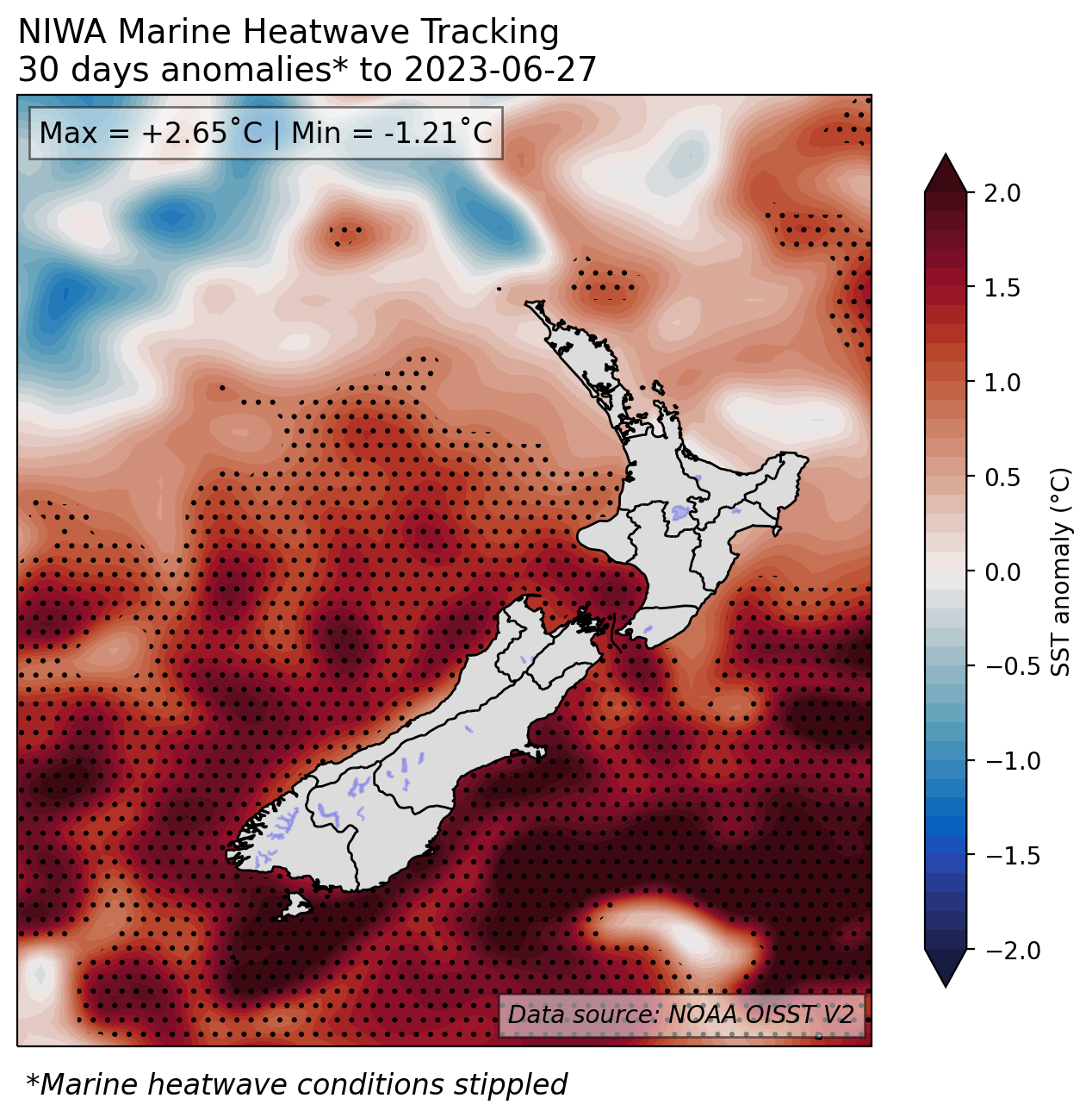
NZ 30-day coastal SST anomalies (to 27 June)
|
North NI |
+0.39˚C |
|
West NI |
+1.35˚C |
|
East NI |
+0.77˚C |
|
North SI |
+1.45˚C |
|
West SI |
+1.39˚C |
|
East SI |
+1.78˚C |
Forecast Confidence
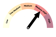
Temperature
|
Forecast confidence for temperatures is medium-high. A colder than average three month period is unlikely, but an increasing frequency of southwesterly air flows and fewer northerlies should lead to less frequent spells of above average temperatures and occasional sharp cold snaps. Marine heatwave conditions will moderate air temperatures near the coast initially, but the effect may ease in the coming months. |
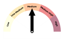
Rainfall
|
Forecast confidence for rainfall is medium. Because El Niño has yet to become firmly established in the tropical Pacific, its influence on New Zealand’s weather patterns will be periodic. While the expected trend is toward fewer tropical moisture plumes that can bring heavy rain, a La Niña-like atmospheric lag effect means that these features can’t be ruled out, particularly in the eastern North Island. |