Dry for northern North Island, wet for much of South Island
|
Rainfall |
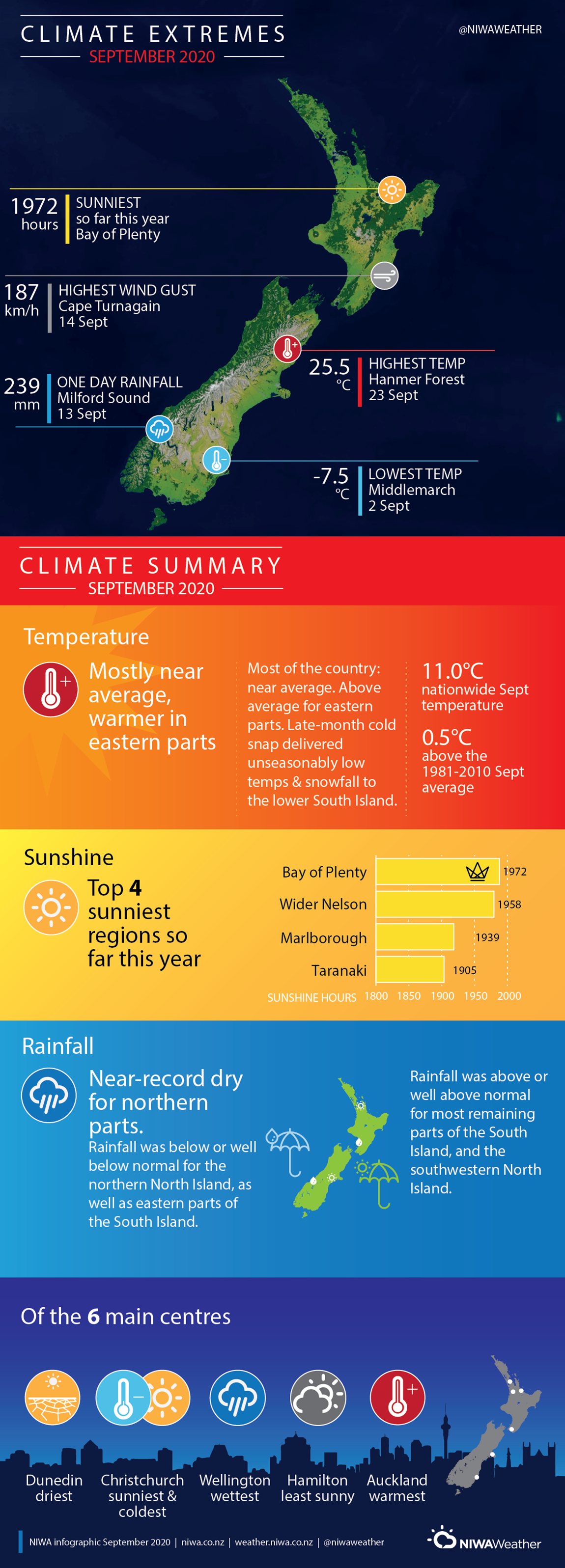
Rainfall was well below normal (<50% of normal) for much of Northland, Auckland, Coromandel Peninsula, and Bay of Plenty. Below normal rainfall (50-79% of normal) was observed in much of Waikato, East Cape, Gisborne and coastal parts of northern Taranaki. Above normal (120-149% of normal) or well above normal (>149% of normal) rainfall was observed in much of the South Island and the southern North Island including Southland, western and central Otago, north Canterbury, the northern West Coast, Wellington, Wairarapa, the Kapiti Coast and Manawatu-Whanganui. Rainfall was typically below normal for easternmost parts of the South Island from Christchurch to Dunedin. |
|
Temperature |
Temperatures were near average (±0.50°C of average) for most of the country. Temperatures were above average (0.51°C to 1.2°C above average) in eastern parts of Otago, Canterbury, Hawke’s Bay and Gisborne, as well as northern parts of Tasman and Marlborough. |
|
Soil Moisture |
As of 1 October, soil moisture was lower than normal for eastern parts of Otago and Canterbury from Dunedin to Christchurch, as well as parts of Northland, Auckland, coastal Bay of Plenty and East Cape. Soil moisture was considerably lower than normal in North Otago and South Canterbury – these areas were categorised as “Dry” or “Very Dry” according to NIWA’s New Zealand Drought Index. Soil moisture was higher than normal in parts of western Otago and eastern Marlborough. Soil moisture was typically near normal for remaining areas of New Zealand. |
Overview
September 2020 was characterised by higher than normal mean sea level pressure over the northern North Island and the Tasman Sea, with lower than normal pressures to the southeast of New Zealand. This pressure set up resulted in a westerly airflow anomaly across the country (i.e. more westerly winds than normal). The prevalence of high pressure over the northern North Island suppressed rainfall, resulting in a very dry month for that area of the country. September rainfall was well below normal (<50% of normal) for much of Northland, Auckland, Coromandel Peninsula and Bay of Plenty. Rainfall was below normal (50-79% of normal) for much of Waikato, coastal parts of northern Taranaki, East Cape and Gisborne. It was also a dry month along parts of the east coast of the South Island, which were sheltered from the prevailing westerly winds by the inland mountain ranges. Rainfall was well below normal in Dunedin, and below normal (50-79% of normal) for other easternmost areas of Otago and Canterbury as far north as Christchurch. In contrast, it was a wet September for southwestern parts of the North and South Islands, and much of the inland and northern portions of the South Island. Rainfall was above normal (120-149% of normal) or well above normal >149% of normal) for Southland, western and central Otago, north Canterbury, the northern West Coast, Wellington, Wairarapa, the Kapiti Coast and Manawatu-Whanganui. Remaining parts of New Zealand typically experienced near normal (80-119% of normal) rainfall totals for the month.
September temperatures were near average (-0.50 to +0.50°C of average) for most of the country. The exception was eastern parts of Otago, Canterbury, Hawke’s Bay and Gisborne where temperatures were above average (0.51°C to 1.20°C above average). These areas were located to the lee of the inland mountain ranges given the prevailing westerly winds, and the mild temperatures were likely a result of the Foehn effect (when air warms and dries as once it passes over elevated terrain). September temperatures were also above average for northern parts of Tasman and Marlborough. It was an especially warm month in Banks Peninsula, Motueka and Wairoa where September temperatures were well above average (>1.20°C above average). Overall, the nationwide average temperature in September 2020 was 11.0°C. This was 0.5°C above the 1981-2010 September average, making it New Zealand’s seventeenth-warmest September since NIWA’s seven station temperature series began in 1909. It has now been 44 consecutive months since New Zealand’s nationwide average temperature was below average.
Further Highlights:
- The highest temperature was 25.5°C, observed at Hanmer Forest on 23 September.
- The lowest temperature was -7.5°C, observed at Middlemarch on 2 September.
- The highest 1-day rainfall was 239 mm, recorded at Milford Sound on 13 September.
- The highest wind gust was 187 km/h, observed at Cape Turnagain on 14 September.
- Of the six main centres in September 2020, Auckland was the warmest, Dunedin was the driest, Christchurch was the sunniest and coldest, Wellington was the wettest and Hamilton was the least sunny.
- Of the available, regularly reporting sunshine observation sites, the sunniest four regions in 2020 so far are Bay of Plenty (1972 hours), Wider Nelson (1958 hours), Marlborough (1939 hours) and Taranaki (1905 hours).
Download
- Climate Summary for September 2020 (PDF 452.7 KB)
- Climate Statistics for September 2020 (PDF 68.3 KB)