Most dynamical climate models monitored by NIWA indicate the tropical Pacific will be in a La Niña state over the coming 6 months...
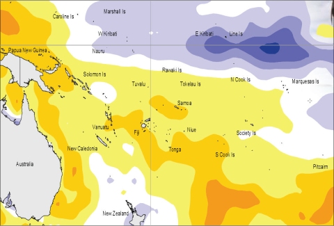
The tropical Pacific has moved steadily towards La Niña conditions over the past few months. The tropical circulation exhibits suppressed convection near the Date Line and enhanced convection over Indonesia, with enhanced trade winds over the western Pacific. The Southern Oscillation Index rose in July to near +2, with the 3–month mean near +1. The TRMM ENSO index fell to –2 in the 30–day mean to 27 July (values of –1.0 or less are considered typical of La Niña conditions). A similar evolution is evident in the ocean. A “cold tongue” is evident along the Equator in to the east of the Date Line, with positive SST anomalies in the far west and in the extra-tropics (of the Southern Hemisphere). The NINO3 and NINO4 anomalies were around –0.7°C and –0.2°C, respectively, for July (MJJ averages of –0.1°C and +0.1°C, respectively). At the sub-surface, a strong negative heat content anomaly lies east of the Dateline and is propagating east. An MJO pulse is positioned over the Indian Ocean and is forecast to stay slow-moving over the coming two weeks. This may reinforce the present OLR pattern, with enhanced convection over Indonesia, and suppressed convection north of the Solomon Islands.
Most dynamical climate models monitored by NIWA indicate the tropical Pacific will be in a La Niña state over the coming 6 months, and that the event will ease in early 2011. Statistical models indicate a weaker response, but are mostly in qualitative agreement with trends shown by the dynamical models. The NCEP ENSO discussion of 8 July states that La Niña conditions are likely to develop during July–August. The IRI summary of 15 July indicates a ~80% probability of La Niña conditions through the rest of 2010 (and 20% probability for neutral conditions).

Surface temperature anomalies (ºC) for July 2010
