Meteorological forecasting centres across the Southwest Pacific are predicting near average numbers of tropical cyclones for the 2013–14 season (November 2013 to April 2014).
On average, 10 named tropical cyclones occur in the Southwest Pacific {between 135°E (mid-Gulf of Carpentaria) and 120°W (French Polynesia)} each season (November to April). The outlook indicates that 8 to 12 named cyclones are expected for the coming season. Tropical cyclone (TC) activity between Vanuatu and New Caledonia as well as east of the International Date Line is expected to be normal or below normal over the whole of the season. Normal or slightly above normal activity is expected for countries close to the International Date Line and near the Gulf of Carpentaria.
Most countries west of the International Date Line, including Papua New Guinea, the Solomon Islands, and Fiji are likely to experience close to normal activity because of ENSO-neutral conditions. It should be recognised that increased activity in general is expected as the TC season progresses. Note that the forecast of normal activity for islands like New Caledonia, Vanuatu, Fiji, and Tonga indicates two or more cyclones could interact with each of those countries during the season. At least one or more severe tropical cyclones (Category 3 or higher[1]) could occur anywhere across the Southwest Pacific during the season. All communities should remain vigilant and follow forecast information provided by their national meteorological service.
On average, New Zealand experiences at least one ex-tropical cyclone passing within 550km of the country every year. For the coming TC season, the risk for New Zealand is slightly higher than normal. If an ex-tropical cyclone comes close to the country, it has a higher probability of passing east rather than west of Auckland city.
Outlook analysis
ENSO neutral conditions are indicated by sea surface temperature anomalies across the central and eastern Equatorial Pacific Ocean, and the atmospheric circulation patterns over French Polynesia and northern Australia. The expectation is that near normal tropical cyclone (TC) activity is likely for most islands in the Southwest Pacific during the 2013–2014 season. TC activity is expected to be near average with 8 to 12 named TCs over the November 2013–April 2014 period for the Southwest Pacific.
On average, 10 tropical cyclones occur each year for the Southwest Pacific region. Southwest Pacific TCs are grouped into classes ranging from 1 to 5, with 5 being the most dangerous. For the coming TC season, at least four storms are predicted to reach at least Category 3, with mean wind speeds of at least 64 knots or 118 km/h (so-called 'hurricane force' winds). Of those systems, three storms may reach at least Category 4 strength, with mean wind speeds of at least 86 knots or 159 km/h. While Category 5 strength TCs have not been prominent for ENSO neutral seasons like the current one, this type of event is still possible. All communities should remain alert and prepared for such an event.
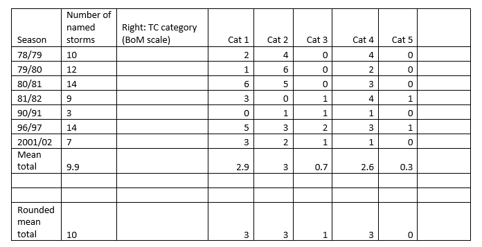
Tropical cyclones significantly impact the Southwest Pacific each year. Countries like Vanuatu and New Caledonia typically experience the greatest activity, with an average of about 2 or 3 TCs passing close to land there each year. The forecast for this season indicates near normal or slightly reduced tropical cyclone activity for the 2013–14 season for many islands east of the International Date Line and also for the region between Vanuatu and New Caledonia. Near normal TC activity is expected for countries situated close to the International Date Line including Fiji, Samoa, Tonga, while slightly elevated activity is expected for Niue and New Zealand.
On average, New Zealand usually experiences at least one interaction per season with an ex-tropical cyclone during ENSO neutral conditions. Most of the analog seasons identified for this forecast (1978/79; 1979/80; 1980/81; 1981/82; 1990/91; 1996/97; 2001/02) show an ex-tropical cyclone coming close (within 550km) to the country. Significant wind, waves and rainfall are possible from these systems. Their effects can be spread over a larger area when the ex-tropical cyclone meets a higher latitude high pressure system.
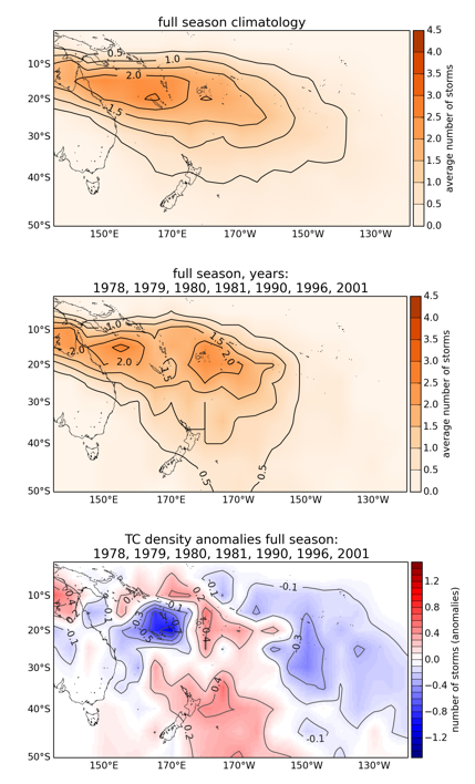
Even though TC activity is expected to be near normal or below normal for some countries, historical cyclone tracks (see supporting information for this forecast, Figure 2) indicate that TCs can affect parts of French Polynesia (including the Society Islands and the Austral Islands) and the Southern Cook Islands, especially late in the TC season. As with the majority of other years, the late TC season (February–April) is expected to be the most active time in the Southwest Pacific.
All Pacific Islands should remain vigilant in case conditions in the equatorial Pacific change during the tropical cyclone season. Past ENSO neutral seasons have seen tropical cyclone tracks with increased sinuosity (irregular or looping motions rather than have a curvilinear trajectory), which means they have potential to impact a large area.
New Zealand's National Institute of Water & Atmospheric Research (NIWA) and Meteorological Service of New Zealand (MetService) along with meteorological forecasting organizations from the Southwest Pacific, including the Australian Bureau of Meteorology, and the Pacific Island National Meteorological Services have prepared this tropical cyclone outlook.
Background
Tropical cyclones (TCs) in the Southwest Pacific usually develop between November and April, but occasionally they can occur in October and May, and very rarely in June, July and August.
Peak cyclone season is usually from January to March. In seasons with similar background climate conditions to present, several tropical cyclones occurred over the Gulf of Carpentaria and countries near the International Date Line. In addition, TCs also occurred near Fiji, Tonga, and Niue while a few affected other areas. On average, nearly half of the tropical cyclones that developed since the 1969-70 season have reached hurricane force with mean wind speeds of at least 64 knots (118 km/h).
To find past analogs to describe the climate state leading into the upcoming TC season, the past May-October conditions were examined for the tropical Pacific for 1969 to present. For the majority of winter and early spring, the ENSO system has been in a neutral state.
The global climate forecast models discussed by the international climate forecast community involved in the Island Climate Update suggests neutral ENSO conditions are most likely for 2013-14 TC season. Close to neutral conditions exist at present for both equatorial sea surface temperatures and the atmospheric circulation in the Southwest Pacific. This has meant that the analog selection for the TC forecast was narrowed to include only past ENSO neutral cyclone seasons.
We used a joint ENSO index that combines the Southern Oscillation Index (SOI) with the most widely-used oceanic index of sea surface temperature anomalies in the equatorial central-western Pacific (NINO3.4). This joint ENSO index is described in Gergis and Fowler (2005) who term it the "Coupled ENSO Index" (CEI). Using the CEI, we selected analog TC seasons for the 2013-14 forecast. We highlighted seasons when the equatorial SSTs and the SOI were in the neutral range (i.e. neither El Nino nor La Nina as defined by the CEI) during the pre-season May-October period. In addition, the analogues were restricted to seasons when ENSO 'NEUTRAL' conditions applied to the majority of the austral warm season (November-April).
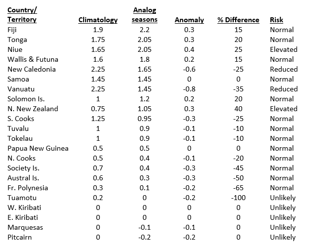
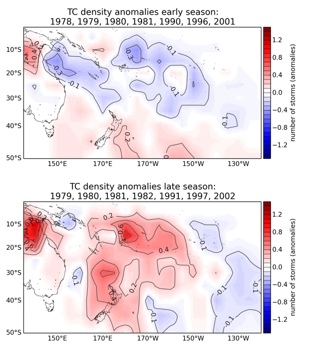
Seven analog tropical cyclone seasons (1978/79; 1979/80; 1980/81; 1981/82; 1990/91; 1996/97; 2001/02) were identified using the approach above. Note that the small number of analog seasons relates to the brevity of the high-quality TC data set (only 42 cyclone seasons), the availability of TC track data, and the limited number of similar analogs to this season. 2012-13 could also be considered an analog to the current season; however, the track data for that season are not yet available.
The Island Climate Update TC forecast spans portions of three responsibility regions that are covered by international monitoring and forecast agencies (RMSC Nadi, TCWC Brisbane and TCWC Wellington). We used a high quality set of past TC tracks derived from the Australian Bureau of Meteorology which covers 135°E to 120°W longitude to draw on past TC tracks for this seasonal forecast. This region encompases a basin that is defined by climatology rather than geopolitical or meteorological boundaries (Diamond et al., 2011). The analog tracks and anomalies for this region suggests TC activity is likely to be below normal east of the International Date Line, including the Society Islands and Austral Islands (Table 1; Figure 1 & 2). The main TC genesis region is expected to lie within a band between 12 – 14°S (and from the eastern Solomon Islands to Wallis & Futuna). While there is a low likelihood of a Category 5 system occurring, recent analogs suggest this type of event is still possible, and therefore this situation cannot be ruled out. A total of 10 named storms on average are expected; the range of variation between analog seasons suggests 8 to 12 for the total TC count (all named storms) within the forcast area could occur.
Based on previous research (Diamond et al., 2012), no strong bias for track orientations during extra-tropical transition (ETT) are expected in the region during ENSO neutral conditions. However, recent research has indicated TC track sinuosity increases during neutral ENSO events (Philip Malsale, Vanuatu Meteorological Service, personal communication). This means that weaker tropical cyclones, such as a Category 1 system, might 'wander' or stall, causing prolonged or widespread effects. ENSO neutral TC tracks between the point of genesis and ETT usually cover a broad region south of Fiji eastward to due south of Niue (mean longitude of ~172°W and a heading of ~165° at 25°S). About 50% of all historical TC tracks for the selected analog seasons made ETT within ±10° of the International Date Line.
A split of the analog tropical cyclone seasons into early (November – January) and late (February – April) periods suggests TC activity will increase during the latter half of the TC season (Figure 3). A change in the foci of TC activity is also apparent as the season progresses (particularly for islands identified near and to the east of the Date Line). Activity northeast of Fiji is expected to pick up as the season progresses. Fiji, Samoa, Tonga, Niue and New Zealand are also expected to experience increased risk as the TC season progresses.
TC intensity is related to how long developing cyclonic systems reside in the deep tropics and feed on warm waters for their growth. In addition, the subtropical jet and South Pacific Convergence Zone (SPCZ) mutually interact and contribute to shear during ex-tropical transition. It should also be noted that the interplay of a hemispheric-scale atmospheric circulation with the timing of a Madden-Julian Oscillation (MJO) passage can also have significant bearing on TC activity in the region.
Previous work (Lorrey et al., 2013) indicates New Zealand experiences at least one ex-tropical cyclone passing within 550km of the country every year. For the coming TC season, the risk for New Zealand is slightly elevated. If an ex-tropical cyclone comes close to the country, it has a higher probability of passing east rather than west of Auckland city.
References
Gergis, J. and A.M. Fowler (2005), Classification of synchronous oceanic and atmospheric El Niño-southern Oscillation (ENSO) events for palaeo-climate reconstruction. International Journal of Climatology.
Diamond, H.J., Lorrey, A.M., Knapp, K.R. and Levinson, D.H. 2011. Development of an enhanced tropical cyclone tracks database for the Southwest Pacific from 1840-2010. International Journal of Climatology.
Diamond, H.J., Lorrey, A.M. and Renwick, J.A. 2012. A Southwest Pacific Tropical Cyclone Climatology and Linkages to ENSO. Journal of Climate.
Lorrey, A.M., Griffiths, G.M., Fauchereau, N. Chappell, P., Diamond, H.J. and Renwick, J. 2013. An ex-tropical cyclone climatology for Auckland, New Zealand. International Journal of Climatology.
Contacts for comment
In New Zealand:
Mr. Steve Ready Manager, Wellington RSMC (Regional Specialized Meteorological Centre) MetService New Zealand
Dr Nicolas Fauchereau Climate Scientist, NIWA
Other regions:
In the Pacific Islands, please contact your local national meteorological service for information about how this guidance should be interpreted.
For Australia and associated offshore islands, please contact the Australian Bureau of Meteorology for information about how this guidance should be interpreted.
For French Polynesia and New Caledonia, please contact MeteoFrance for information about how this guidance should be interpreted.
[1] See http://www.bom.gov.au/cyclone/about/intensity.shtml