Twenty one years after New Zealand’s most devastating cyclone struck the country, the effects of Cyclone Bola are still with the East Coast of the North Island.
Severe storms like Bola create numerous landslides and cause deep erosion especially in steep hill country. Vast quantities of debris are produced and – as scientists are discovering – it can take hours to decades for the stones and mud to reach the coast. Mud flushed out through creeks and rivers, leaves distinctive deposits on river banks, in lakes, and even offshore.
That’s according to new research being discussed by scientists at an international workshop in Gisborne this week (5–9 April). They are looking at the initial findings of a 10-year international programme investigating how severe disturbances such as storms and earthquakes are felt from mountain tops to the deep ocean.
Most of the events that shape the Earth’s surface above and below sea level leave a record, or fingerprint, of their impacts in the sediment layers that accumulate on river banks, flood plains and the ocean floor.
Through an almost forensic investigation of the sediment deposits scientists are unraveling the full impact of past events to better predict future effects of changes in climate and land use, as well as volcanic eruptions and earthquakes.
But predicting how the landscape will react to change requires knowledge of how the earth works; what are the causes and responses to a major disturbance. This is especially important for coastal communities as over 40% of the world’s population lives within a 100 km of the shore and is strongly dependent upon its resources for survival.
The Waipaoa River and adjacent ocean, near Gisborne, is one of two research sites in the programme which is funded by the United States National Science Foundation. The other site is the massive Fly River system in tropical Papua New Guinea.
Gisborne was chosen as an ideal ‘temperate climate’ site to study sediment dispersal because it is strongly affected by land-based activities such as deforestation, vigorous maritime weather, volcanic eruptions, and also ex-tropical cyclones like Cyclone Bola.
Despite its small size, Gisborne’s Waipaoa River carries on average more than 4100 truckloads of mud to the ocean each day. Over a year, the East Coast of New Zealand contributes 0.3% of mud entering the world ocean, which makes the Waipaoa and Waiapu rivers some of the world’s muddiest rivers.
But to put this in context, the massive Fly River system in tropical Papua New Guinea carries, on average, a staggering 27,000 truckloads of mud a day.
At the workshop results from both the Gisborne and Papua New Guinea studies will be collated, allowing scientists into identify new science and research gaps, and begin planning for the next phase which includes the development of predictive models.
Key findings to be discussed at the workshop include:
- Human impacts in the Waipaoa catchment are seen as the cause for 75% of mud, sand and carbon delivered to the sea.
- The mountainous catchment of the Fly River in PNG is the location of very large mining operations (e.g. Ok Tedi) and other human activities, but impacts there are diluted by transport processes in the main river, and little effect reaches the ocean.
- El Niño/La Niña driven climate influence storms and erosion in PNG and eastern NZ, but Antarctic influences are also evident in NZ.
- Geological investigations at Lake Tutira, north of Napier, show that around 50 Bola-sized storms might have impacted the East Coast over the past 7,000 years, but there were a handful of potentially even larger events.
Around 85 scientists from the United States, Europe, China, Australia, and New Zealand are attending. The workshop runs from April 5–9 and is funded by the United States National Science Foundation (NSF).
For more information, contact:
Prof Steve Kuehl, Marine Geologist, Virginia Institute of Marine Science Co-Convener of the MARGINS Source-to-Sink Workshop
Dr Alan Orpin, Marine Geologist, NIWA Co-Convener of the MARGINS Source-to-Sink Workshop
Dr Nicola Litchfield, Geologist, GNS Science Co-Convener of the MARGINS Source-to-Sink Workshop
FAST FACTS:
What is the Source-to-Sink (S2S) Initiative?
- The S2S Initiative is part of a 10-year international research programme, funded by the National Science Foundation (NSF).
- It is a comprehensive study involving two field programmes – one in Gisborne, New Zealand, and the other on the Fly River system in Papua New Guinea.
- The S2S Initiative is looking at land and sea dispersal systems to find out:
- How tectonics, climate, sea-level fluctuations, and other factors affect the production, transfer, and storage of sediments from their sources to their sinks (where they end up)?
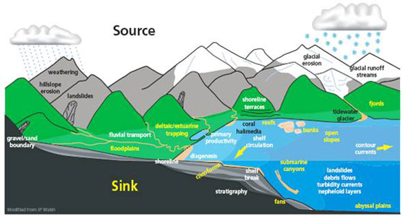
- What processes initiate erosion and sediment transfer?
- How can we use the record left by sediment dispersal to make predictions about future climate change, effects on ecosystems, major weather events etc?
For more information go to http://www.nsf-margins.org/index.html
What is the National Science Foundation (NSF)?
- The National Science Foundation (NSF) is an independent, United States federal agency.
- It was created by Congress in 1950, and now has an annual budget of more than US$6 billion.
- One of the Foundation’s primary roles is to “promote the progress of science.”
- It does this by granting limited-term grants to fund specific research projects around the world.
- The Foundation currently issues approximately 10,000 new awards each year. Most go to individuals or small groups of investigators.
- The research funded by the Foundation is very well respected internationally. NSF-funded researchers have won more than 170 Nobel Prizes as well as many other honours.
For more information go to http://www.nsf.gov/
