The Catchment Land Use for Environmental Sustainability (CLUES) model is being transferred from the ArcMap GIS environment to ArcGIS Pro and we are looking for volunteers to help test the new model interface with a limited Beta release of the model.
NIWA’s Catchment Land Use for Environmental Sustainability (CLUES) model is a GIS-based system that predicts the effects of land-use change and farm practice scenarios on water quality and a range of socio-economic indicators at the catchment scale. CLUES allows users to create land use change and land management scenarios and view results in map or tabular displays. It was developed as a decision support tool for catchment managers, land-use planners and regulators and is available publicly for non-commercial use.
CLUES was developed by NIWA for the Ministry of Agriculture and Forestry (now part of the Ministry for Primary Industries) and the Ministry for the Environment and contains aspects of three existing water quality models (SPARROW, OVERSEER and SPASMO) as well as a socio-economic model. Various agencies contributed to the development of CLUES including AgResearch, Landcare Research, Plant & Food Research, Aqualinc Research and Harris Consulting.
CLUES is provided as a front-end interface for ArcMap and comes with a geospatial database that includes land use for the base year 2018 and stream data from the River Environments Classification, REC. The GIS platform allows geo-visualisation of both the model input data and model outputs. Users can also add their own spatial data for display and to create scenarios.
For each river reach in the REC stream network, CLUES predicts the annual average loads and yields of nutrients (total nitrogen and total phosphorus), total suspended solids and E. coli. Estimates of nutrient concentrations are also calculated.
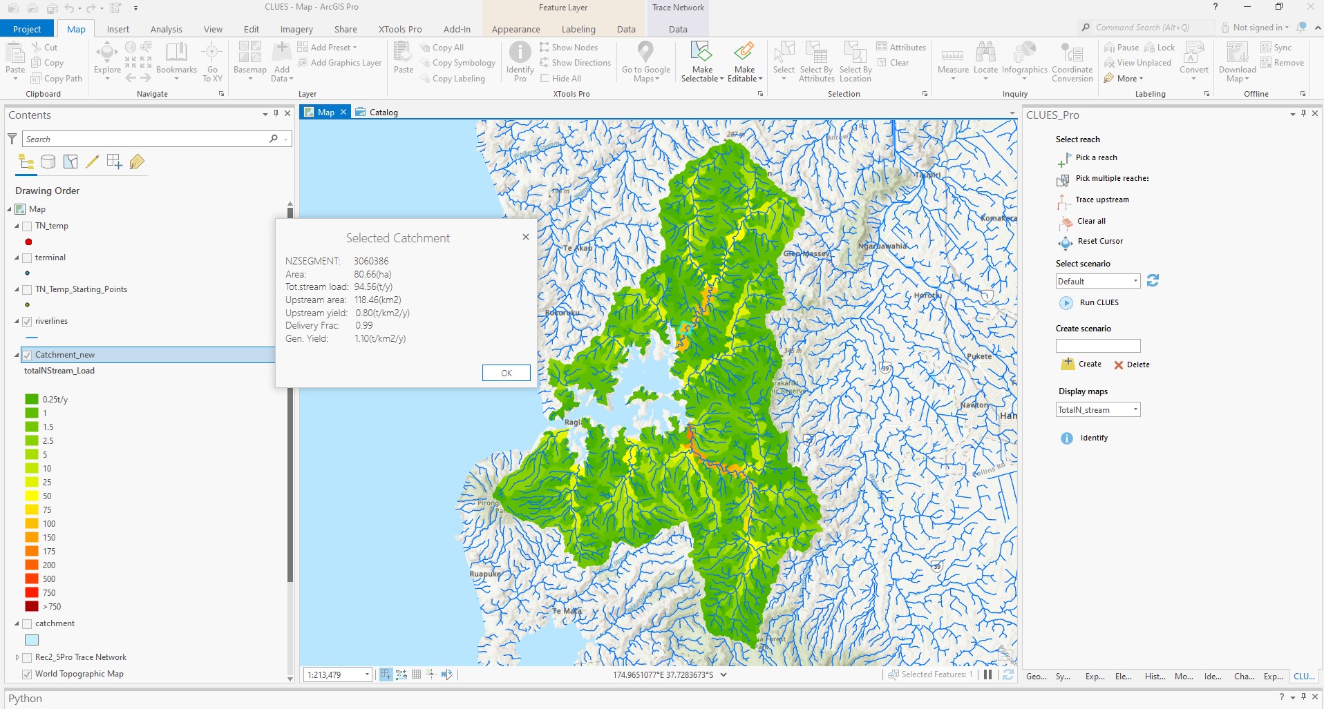
What’s new in CLUES Pro Beta?
Transition to ArcGIS Pro has required a rebuild of the model which means some of the functionality of CLUES is not yet available or is being replaced by new features. Modules have been coded for TN, TP and E. coli with a new sediment module based on NIWA’s sediment yield estimator planned for 2023. Changes that have been made include the following:
- A new-look dockable interface that is compatible with ArcGIS pro.
- A national rather than regional database that allows simulations to be run in multiple regions at once.
- Updated spatial input data, including the latest version of the REC (v. 2.5) drainage network, and a new LCDB5 land use layer for the baseline year 2017.
- Development of catchment selection and tracing tools compatible with REC 2.5 that offers greater flexibility than those built into ArcGIS Pro. Like the original version of CLUES, the selection tools allow users to select single or multiple stream segments at any location and single or multiple catchments by terminal/coastal segment.
- Estimates of attenuated loads from each REC subcatchment that are delivered to coast.
Planned further development
Ahead of the full model release in 2024, we plan to undertake the following tasks:
- Re-calibrate the model by region or regional group to: a) improve regional fit; b) make use of updated water quality monitoring data sets; c) be compatible with updated land use; and d) offer an alternative to the Overseer component of CLUES.
- Integration of the NZ Sediment Yield Estimator (Hicks et al. 2019) into the CLUES framework.
- Re-integrate the CLUES Estuary model (Plew et al. 2015) into CLUES Pro. This tool estimates nitrogen and phosphorus concentrations for 370 estuaries around the country.
- Translation of CLUES load estimates into changed National Objective Framework attribute states for selected attributes.
- Integrate and improve the currently stand-alone CLUES yield modification tool into CLUES Pro. This tool allows users to build land management scenarios that take into account spatial variability of land management practices within REC subcatchments. This tool will be developed with research into the effectiveness of edge of field mitigations being undertaken by NIWA.
- Model documentation including a new user manual.
CLUES for ArcMap downloads
CLUES for ArcMap is still available for download. You will need access to ArcMap 10.6 or 10.8 to run CLUES. We are currently working on transferring CLUES to ArcPro with a new release planned for 2023.
CLUES is available for download free of charge for non-commercial use, downloading and using CLUES implies that you have read and accept the user licencing agreement. CLUES software, documentation and data files can be downloaded from the links below.
|
Download type |
Description |
Links N.B. some of these files are very large |
|
Addin_Arcmap10.6 and 10.8 |
Zip folder containing the CLUE model software as an ArcMap plugin |
CLUES software for ArcMap 10.6 [5.8MB zip file] CLUES software for ArcMap 10.8 [4.1MB zip file] |
|
Regional geodatabases |
Zip folders holding the shapefiles of region specific data for CLUES. |
One zip file link for each of the 10 regions: Canterbury [523MB zip file] North Island east [498MB zip file] north Auckland [168MB zip file] Otago [262MB zip file] South [ 337MB zip file] Taranaki [357MB zip file] Tasman [164MB zip file] West Coast [222MB zip file] Waikato [229MB zip file] Wellington [106MB zip file] |
|
CLUES scenario builder |
Python tool for automatically populating CLUES land management scenarios. Zip folder contains the tool and spatial data by region. |
CLUES scenario builder [118MB zip file containing the tool and data files] |
|
Documentation |
CLUES manual, licensing agreement and development reports. |
CLUES documentation [18MB zip file containing document PDFs] |
|
Farm Practice Template |
Spreadsheet for creating land management text files tor the manual development of land management scenarios |
Farm Practice Template [Spreadsheet] |
Download:
CLUES Pro: Beta Release - Modelling the impacts of land-use change and farm practices on catchment water quality. [PDF 3.37 MB]

