Outlook Summary
- ENSO-neutral conditions persisted during May, but oceanic and atmospheric indicators trended closer to El Niño thresholds. El Niño will continue to develop during winter with the potential for a strong event developing by spring.
- Despite a trend toward El Niño, warmer than average sea temperatures remain present in the western Pacific. This is expected to continue to fuel moisture-rich disturbances in the Aotearoa/New Zealand region through at least June, some of which will bring heavy rainfall, snow, and strong winds.
- Higher than normal air pressure is forecast to develop in the Tasman Sea during July and/or August, leading to more southwesterly quarter winds than normal and periods of below normal rainfall, particularly in the north and east of both islands.
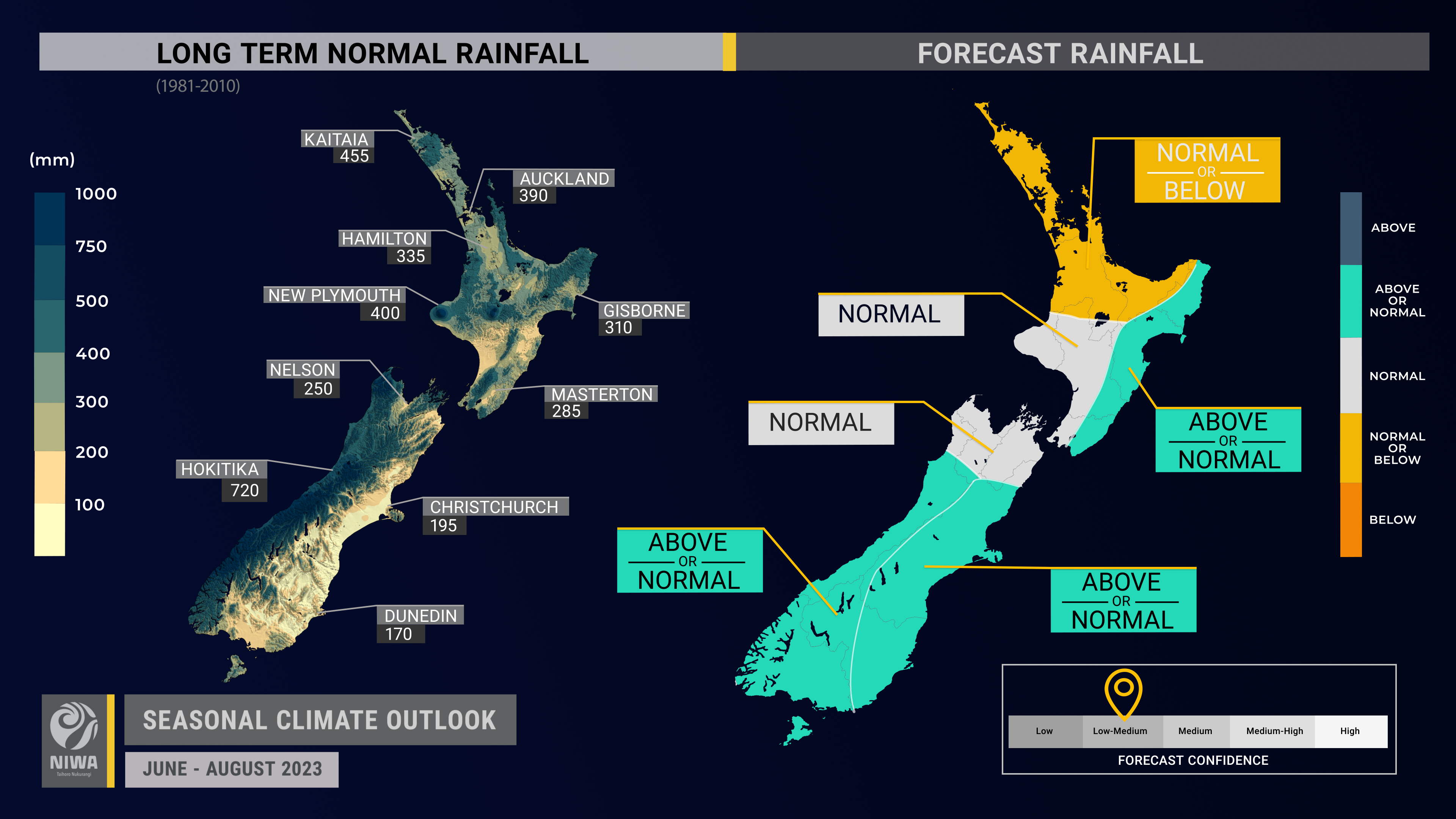
- For the winter season as a whole, rainfall is most likely to be near normal in the west of the North Island and north and west of the South Island. In the east of both islands, rainfall is about equally likely to be near normal or above normal, with June looking particularly wet. In the north of the North Island, rainfall is about equally likely to be near normal or below normal.
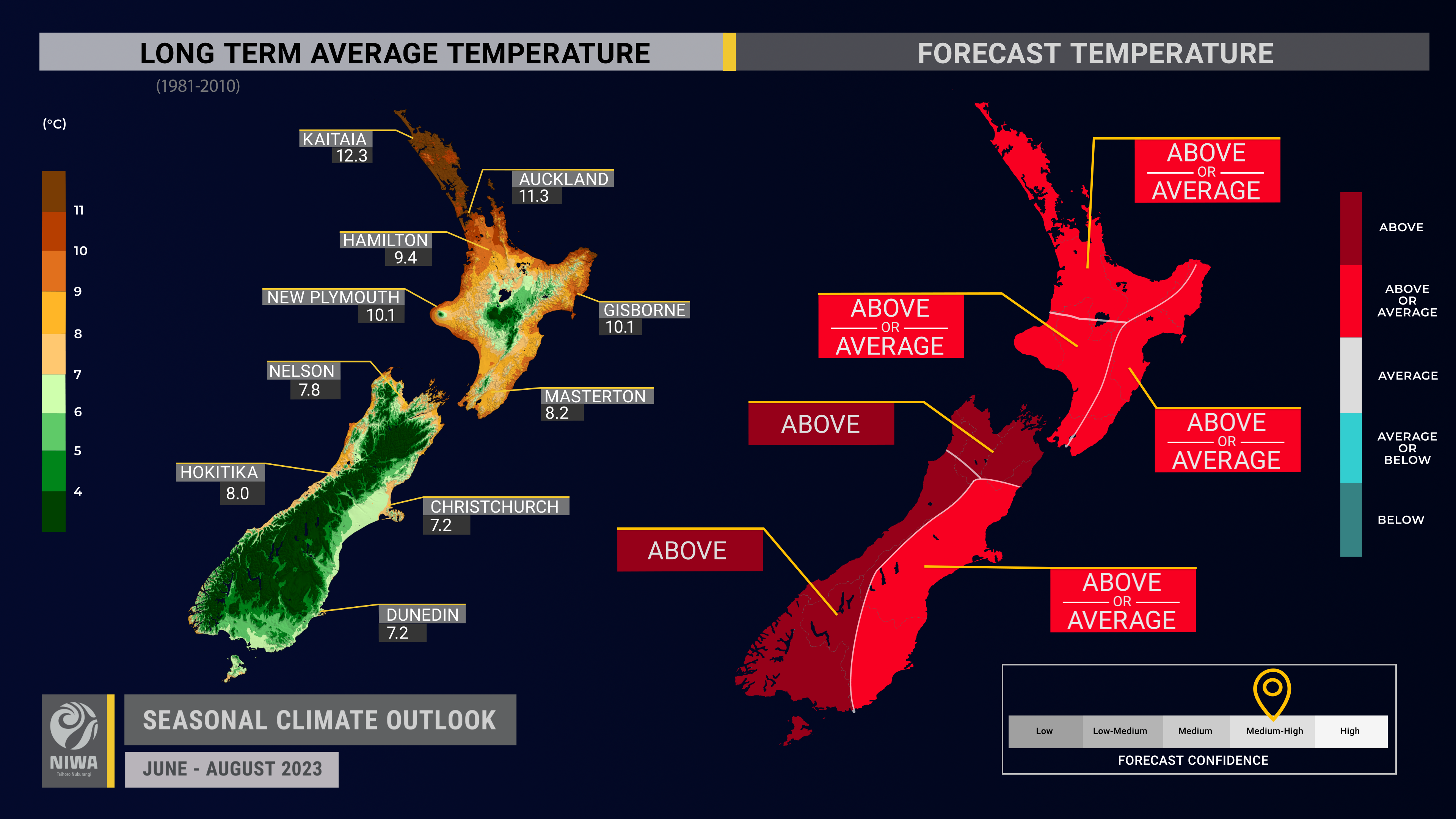
- Winter temperatures are most likely to be above average in the west of the North Island and north and west of the South Island. Temperatures are about equally likely to be near average or above average in all other regions.
- Marine heatwave conditions persisting in New Zealand’s coastal waters will likely prevent a sharply colder than average winter, although more frequent southerly-quarter winds may cause winter 2023 to be colder than recent winters.
- Coastal sea surface temperatures (SSTs) ranged from 0.4˚C to 1.5˚C above average during May. The warmer than average seas will likely have an upward influence on air temperatures, particularly around the start of winter.
- Soil moisture levels are most likely to be near normal in the west of the North Island and north and east of the South Island and about equally likely to be near normal or above normal in all other regions.
- River flows are most likely to be near normal in the north and west of the North Island and north of the South Island. River flows are about equally likely to be near normal or above normal in all other regions.
Regional predictions for June – August 2023
Northland, Auckland, Waikato, Bay of Plenty
The table below shows the probabilities (or percent chances) for each of three categories: above average, near average, and below average. In the absence of any forecast guidance there would be an equal likelihood (33% chance) of the outcome being in any one of the three categories. Forecast information from local and global guidance models is used to indicate the deviation from equal chance that is expected for the coming three-month period. The following outcomes are the most likely for this region:
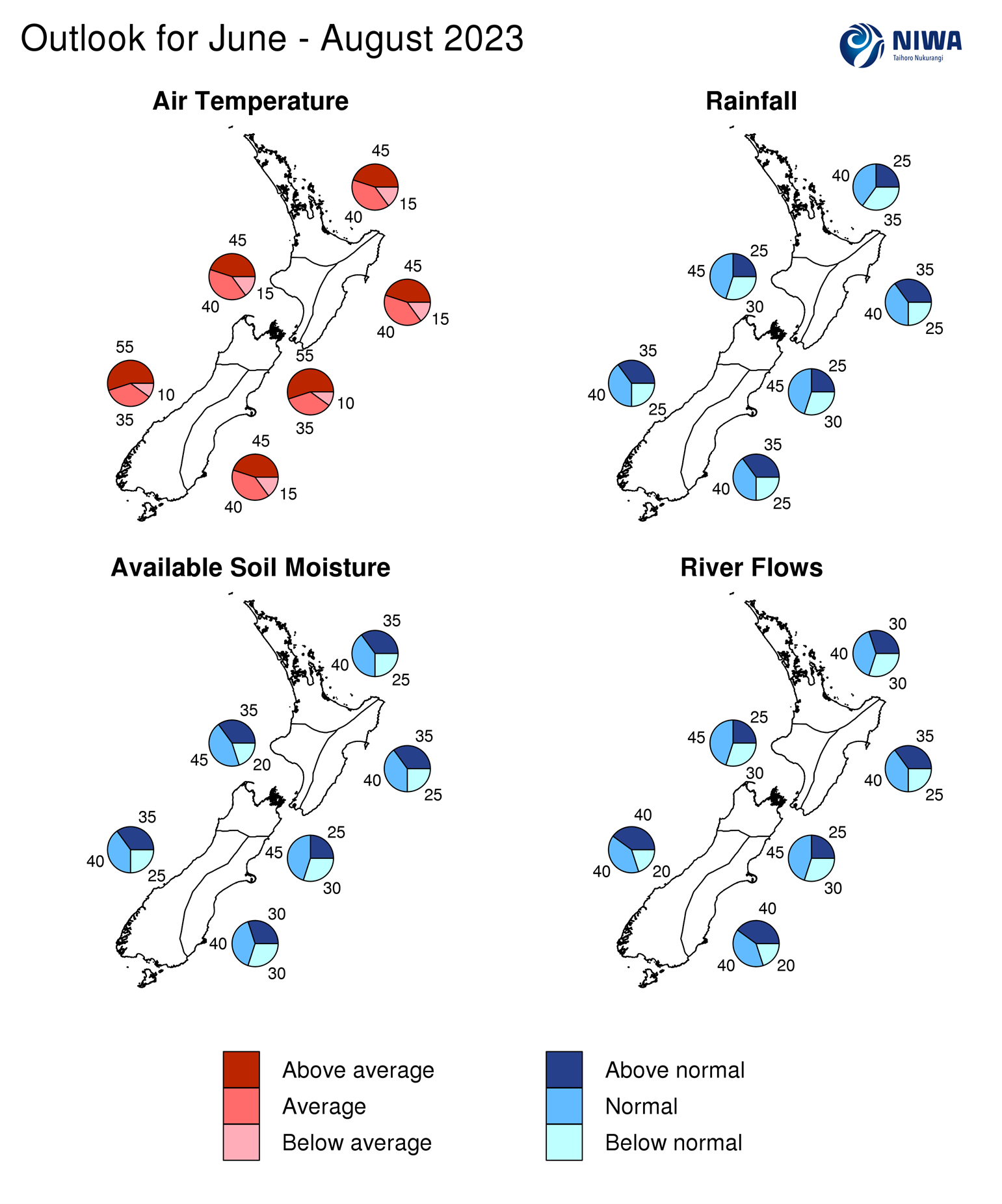
- Temperatures are about equally likely to be above average (45% chance) or near average (40% chance).
- Rainfall totals are about equally likely to be near normal (40% chance) or below normal (35% chance). July and August may feature higher than normal air pressure, leading to spells of drier than normal weather.
- Soil moisture levels are about equally likely to be near normal (40% chance) or above normal (35% chance) while river flows are most likely to be near normal (40% chance).
|
Temperature |
Rainfall |
Soil moisture |
River flows |
|
|
Above average |
45 |
25 |
35 |
30 |
|
Near average |
40 |
40 |
40 |
40 |
|
Below average |
15 |
35 |
25 |
30 |
Central North Island, Taranaki, Whanganui, Manawatu, Wellington
Probabilities are assigned in three categories: above average, near average, and below average.
- Temperatures are about equally likely to be above average (45% chance) or near average (40% chance). Marine heatwave conditions remain present in coastal waters. The warmer than average seas will likely have an upward influence on air temperatures, particularly around the start of winter.
- Rainfall totals are most likely to be near normal (45% chance). Early-to-mid June looks particularly unsettled, with periods of heavy rain and high elevation snow possible.
- Soil moisture levels and river flows are most likely to be near normal (45% chance).
|
Temperature |
Rainfall |
Soil moisture |
River flows |
|
|
Above average |
45 |
25 |
35 |
25 |
|
Near average |
40 |
45 |
45 |
45 |
|
Below average |
15 |
30 |
20 |
30 |
Gisborne, Hawke’s Bay, Wairarapa
Probabilities are assigned in three categories: above average, near average, and below average.
- Temperatures are about equally likely to be above average (45% chance) or near average (40% chance).
- Rainfall totals are about equally likely to be near normal (40% chance) or above normal (35% chance). Early-to-mid June looks particularly unsettled, with periods of heavy rain possible. July and/or August may feature more southwesterly-quarter winds, leading to spells of drier than normal weather.
- Soil moisture levels and river flows are about equally likely to be near normal (40% chance) or above normal (35% chance).
|
Temperature |
Rainfall |
Soil moisture |
River flows |
|
|
Above average |
45 |
35 |
35 |
35 |
|
Near average |
40 |
40 |
40 |
40 |
|
Below average |
15 |
25 |
25 |
25 |
Tasman, Nelson, Marlborough, Buller
Probabilities are assigned in three categories: above average, near average, and below average.
- Temperatures are most likely to be above average (55% chance). Marine heatwave conditions remain present in coastal waters. The warmer than average seas will likely have an upward influence on air temperatures, particularly around the start of winter.
- Rainfall totals are most likely to be near normal (45% chance). Early-to-mid June looks particularly unsettled, with periods of heavy rain. July and August may feature more southwesterly-quarter winds, leading to spells of drier than normal weather.
- Soil moisture levels and river flows are most likely to be near normal (45% chance).
|
Temperature |
Rainfall |
Soil moisture |
River flows |
|
|
Above average |
55 |
25 |
25 |
25 |
|
Near average |
35 |
45 |
45 |
45 |
|
Below average |
10 |
30 |
30 |
30 |
West Coast, Southern Alps and foothills, inland Otago, Southland
Probabilities are assigned in three categories: above average, near average, and below average.
- Temperatures are most likely to be above average (55% chance). Marine heatwave conditions remain present in coastal waters. The warmer than average seas will likely have an upward influence on air temperatures, particularly around the start of winter.
- Rainfall totals are about equally likely to be near normal (40% chance) or above normal (35% chance). July and/or August may feature more westerly winds, leading to spells of wetter than normal weather.
- Soil moisture levels and river flows are about equally likely to be near normal (40% chance) or above normal (35-40% chance).
|
Temperature |
Rainfall |
Soil moisture |
River flows |
|
|
Above average |
55 |
35 |
35 |
40 |
|
Near average |
35 |
40 |
40 |
40 |
|
Below average |
10 |
25 |
25 |
20 |
Coastal Canterbury and the nearby plains, east Otago
Probabilities are assigned in three categories: above average, near average, and below average.
- Temperatures are about equally likely to be above average (45% chance) or near average (40% chance). Marine heatwave conditions remain present in coastal waters. The warmer than average seas will likely have an upward influence on air temperatures, particularly around the start of winter.
- Rainfall totals are about equally likely to be near normal (40% chance) or above normal (35% chance). Early-to-mid June looks particularly unsettled, with periods of heavy rain and high elevation snow possible. July and/or August may feature more southwesterly-quarter winds, leading to spells of drier than normal weather.
- Soil moisture levels are most likely to be near normal (40% chance) while river flows are equally likely to be near normal (40% chance) or above normal (40% chance).
The full probability breakdown is:
|
Temperature |
Rainfall |
Soil moisture |
River flows |
|
|
Above average |
45 |
35 |
30 |
40 |
|
Near average |
40 |
40 |
40 |
40 |
|
Below average |
15 |
25 |
30 |
20 |
Graphical representation of the regional probabilities
Background
The NINO3.4 Index anomaly (which covers the west-central equatorial Pacific) over the last month (through 30 May) was +0.48˚C (climatology: 1991-2020).
The NINO3 region (in the east-central Pacific) reached +0.91˚C, the warmest monthly average value since May 2015 (during the last major El Niño) and notably warmer than May 1997 and 1982 – two years that went on to feature strong El Niño events.
The May monthly Southern Oscillation Index (SOI) was negative (-1.5) during May (climatology: 1991-2020). This was the lowest value since February 2016, or in over seven years.
During May, trade wind strength was near normal in the central equatorial Pacific and above normal in the east. Trends during early June suggest a significant relaxation of trade winds, which will likely result in warming seas in the east-central Pacific.
In the subsurface equatorial Pacific, the most unusually warm waters consolidated in the east with a pocket of anomalies in excess of 4˚C. The remainder of the eastern and central equatorial Pacific exhibited anomalies of 2-4˚C. The warmest actual sea temperatures shifted eastward between April and May, which suggests that the atmosphere will likely begin displaying El Niño-like tendencies via convective anomalies.
Upper-oceanic heat content increased once again across the equatorial Pacific. The area-averaged upper 300m of the ocean was 1.5˚C to 2.0˚C warmer than average in the east, well above the traditional El Niño threshold. Although La Niña ended months ago, the western Pacific continued to exhibit substantial anomalous warmth. This will affect New Zealand’s weather patterns and is elaborated on below.
NIWA’s analysis indicates that ENSO neutral conditions continued during May, but oceanic and atmospheric indicators trended closer to El Niño thresholds. NIWA is still at an El Niño Watch, as NIWA’s ENSO criteria for Alert have not yet been met. However, key indicators are continuing to point to a transition to El Niño by late winter or early spring. With the current guidance, the August-October outlook may move to El Niño Alert. El Niño has a 90% chance of developing by August-October with around a 70% chance of continuing through summer 2023-2024.
During May, convective forcing focused in the western and central tropical Pacific. The eastward migration of the warmest Pacific sea temperatures should result in the central and eastern part of the basin becoming a focal point for convection. However, the persistence of warmth in the West Pacific Warm Pool may allow La Niña-like patterns to continue to occur from time to time in early-to-mid winter, lengthening the “climate driver transition window”.
At the beginning of June, a convective pulse was forecast to move across the central and eastern Pacific into South America and Africa. During mid-June, a pulse of the Madden-Julian Oscillation is forecast to once again pass over the west-central Pacific (phases 6-7). These phases are historically associated with more easterly-quarter winds for New Zealand, bringing wetter than normal conditions to the east and north of both islands.
Based on seasonal predictions of velocity potential, convective forcing may occasionally pass over the west-central Pacific through much of the season before moving eastward into South America and Africa. This approximately corresponds to an MJO progression of 6-7-8-1.
While phase 8 supports drier than normal for much of the country, phases 6-7 favour wetter than normal conditions in parts of the north and east of both islands. Phase 1 leans slightly toward drier than normal conditions in the east and wetter than normal conditions in the west.
Temperatures during phases 6-7 typically favour colder than average in the South Island during winter. During phase 8, the North Island tends to be colder than average. The MJO’s likely avoidance of phases 3-5 may limit the frequency of warm spells during the season, particularly relative to recent winters.
The MJO’s avoidance of phases 3-5 is a by-product of a forecast positive Indian Ocean Dipole (IOD), which is expected to develop during mid-to-late winter, suppressing convection over the eastern Indian Ocean and Maritime Continent. The positive IOD was one climate driver that triggered the drought event that develop in late 2019 and persisted through 2020. Its strength will be important to monitor during spring.
The Southern Annular Mode (SAM) was positive for much of May. On 13 May, the daily AAO value reached 4.2, the highest value since May 1989 (at the end of another La Niña event). The SAM signal favours positive values in early June, owing to high pressure near the South Island. As the signal for El Niño builds through the winter season, the SAM may begin to favour negative values.
New Zealand’s coastal water temperatures became more anomalously warm during May, with increases ranging from +0.2˚C to +0.6˚C. At the end of the month, marine heatwave conditions were occurring around the South Island and lower North Island. The warm seas will likely have an upward influence on air temperatures, particularly around the start of winter, taking the “sting” out of cold, southerly air masses. For more information, see the NIWA Sea Surface Temperature Update.
NZ 30-day coastal SST anomalies (to 30 May)
|
North NI |
+0.43˚C |
|
West NI |
+1.29˚C |
|
East NI |
+0.64˚C |
|
North SI |
+1.22˚C |
|
West SI |
+1.28˚C |
|
East SI |
+1.54˚C |
Forecast Confidence
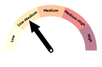
Temperature
|
Forecast confidence for temperatures is medium-to-high. Despite an expected increase in frequency of southerly-quarter air flows, a colder than average winter is unlikely. This is because marine heatwave conditions persist in New Zealand’s coastal waters, particularly near the South Island. Winter 2023 may, however, be colder than recent winters as the effect of El Niño builds. |
Rainfall
|
Forecast confidence for rainfall is low-to-medium. While a transition to El Niño is occurring, the persistence of warmer than average ocean water in the western Pacific, a La Niña-like tendency, is supporting and will continue to support an increased frequency of low pressure systems around New Zealand. Some of these disturbances will come with sub-tropical and/or tropical moisture. El Niño-like patterns may develop during July and/or August, allowing for periods of time with less rain, particularly in the north and east of both islands. |