Outlook Summary
- El Niño Alert criteria continued to be met during July. Central equatorial Pacific sea surface temperatures (SSTs) exceeded El Niño thresholds but the Southern Oscillation Index (an atmospheric indicator) was neutral. Full ocean-atmosphere coupling for El Niño is expected in the next three months, likely persisting through summer.
- Atmospheric pressure is forecast to be above normal to the northwest of Aotearoa/New Zealand and below normal to the south, leading to more southwesterly quarter winds than normal across the country for the season as a whole. Wind speeds are forecast to be stronger than normal, particularly across the South Island and lower North Island.
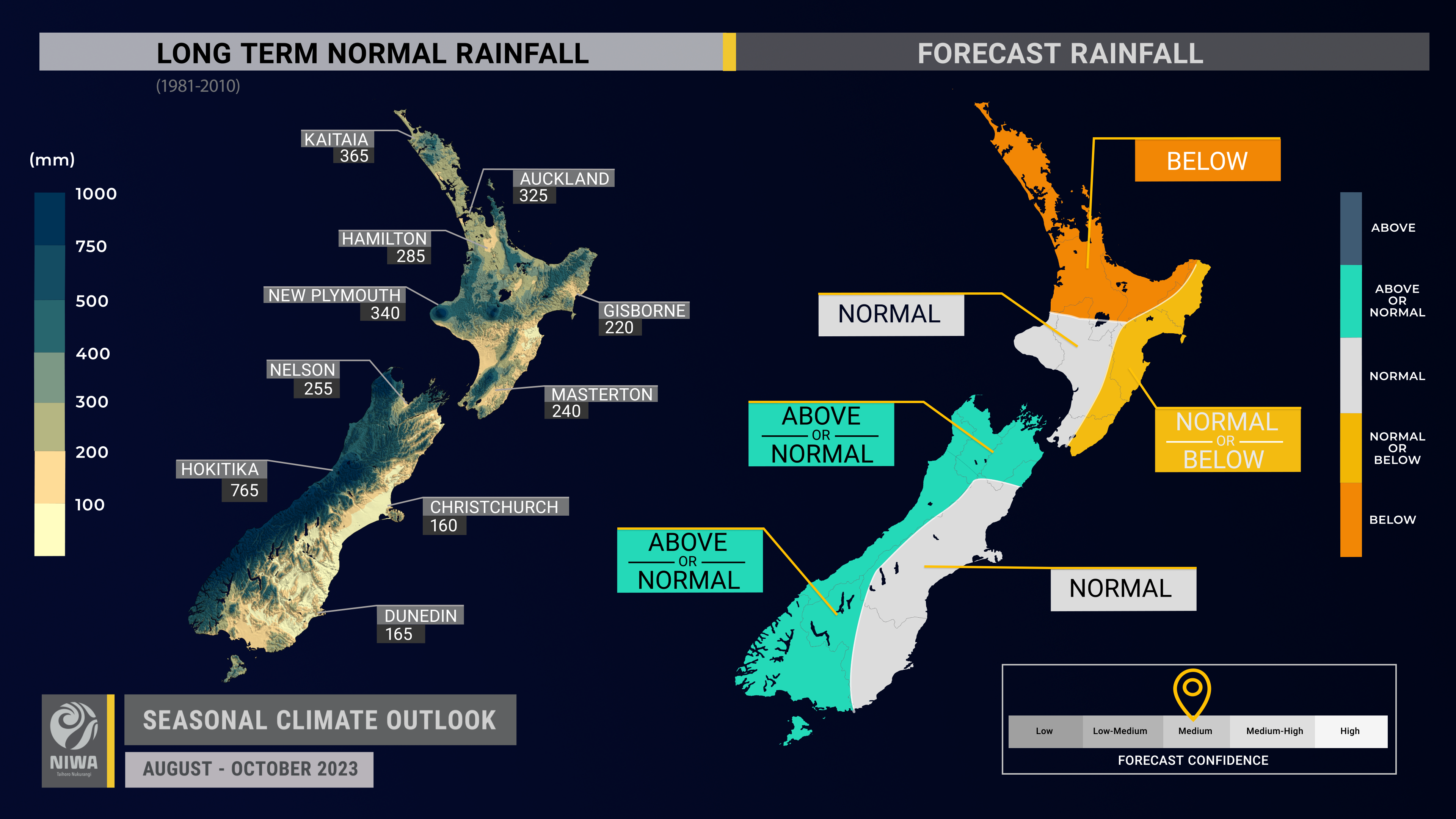
- Rainfall is most likely to be below normal in the north of the North Island, near normal in the west of the North Island and east of the South Island, about equally likely to be near normal or below normal in the east of the North Island, and about equally likely to be near normal or above normal in the west and north of the South Island.
- During the second half of August, frequent westerly winds and low pressure systems are expected to result in occasional heavy rainfall for the South Island, particularly in the west, as well as the western North Island.
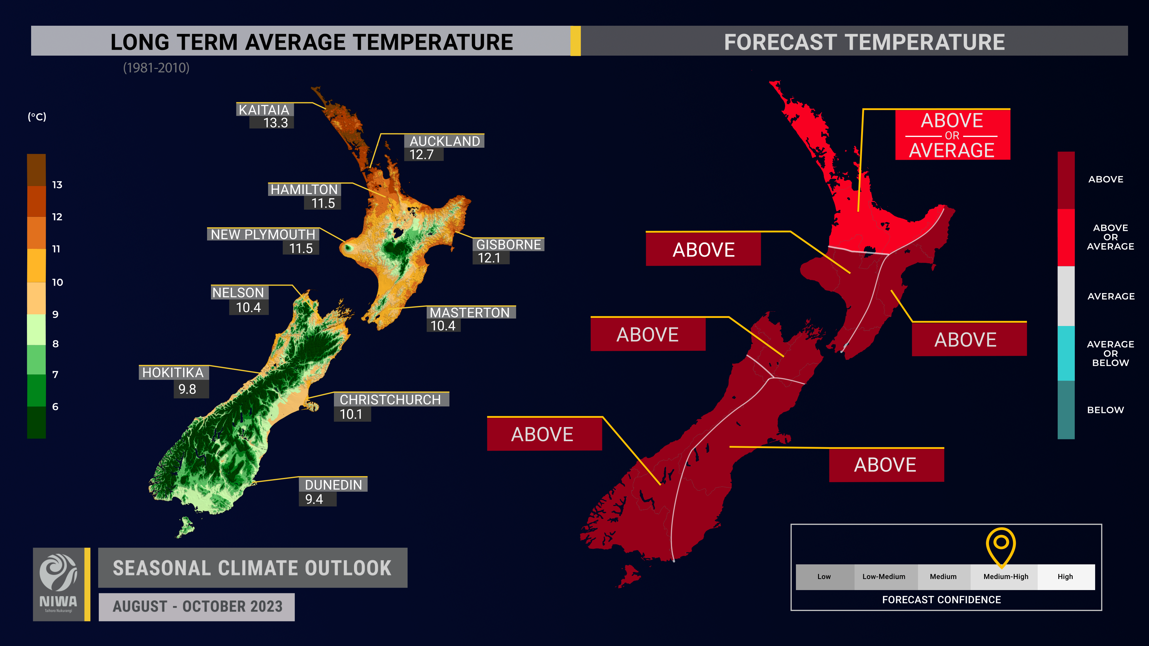
- Temperatures are about equally likely to be near average or above average in the northern North Island and most likely to be above average in all other regions.
- Westerly winds will bring warm air into the region from Australia at times.
- Coastal sea surface temperatures (SSTs) ranged from 0.3˚C to 1.8˚C above average during July. The warmer than average seas may reduce the intensity of episodic cold, southerly air masses that typically occur during late winter and spring.
- Soil moisture levels are most likely to be below normal in the north and east of the North Island, near normal in the South Island, and about equally likely to be near normal or below normal in the west of the North Island.
- River flows are most likely to be near normal in the west and east of the South Island and about equally likely to be near normal or below normal in all other regions.
Regional predictions for August – October 2023
Northland, Auckland, Waikato, Bay of Plenty
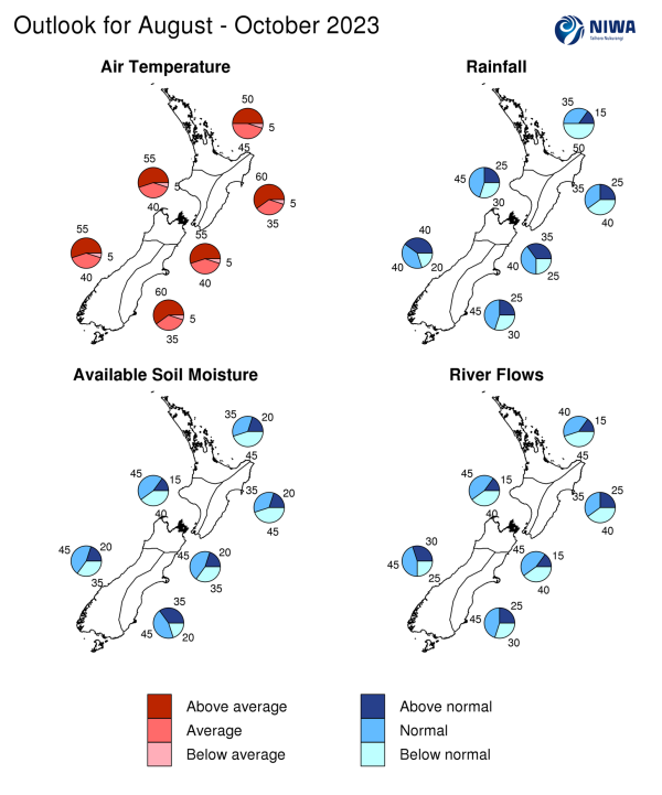
The table below shows the probabilities (or percent chances) for each of three categories: above average, near average, and below average. In the absence of any forecast guidance there would be an equal likelihood (33% chance) of the outcome for any of the three categories. Forecast information from local and global guidance models is used to indicate the deviation from equal chance that is expected for the coming three-month period. All outlooks are for the three months as a whole. There will inevitably be relatively wet and dry days, and hot and cold days, within a season. The exact range in temperature and rainfall within each of the three categories varies with location and season. However, as a guide, the “near average” or middle category for the temperature predictions includes deviations up to ±0.5°C for the long-term mean, whereas for rainfall the “near normal” category lies between 80 per cent and 120 per cent of the long-term mean. The following outcomes are the most likely for this region:
- Temperatures are about equally likely to be above average (50% chance) or near average (45% chance).
- Rainfall totals are most likely to be below normal (50% chance). An increased frequency of high pressure systems near the region will likely lead to spells of drier than normal weather.
- Seasonal wind speeds may be stronger than normal.
- Soil moisture levels are most likely to be below normal (45% chance) while river flows are about equally likely to be below normal (45% chance) or near normal (40% chance).
|
Temperature |
Rainfall |
Soil moisture |
River flows |
|
|
Above average |
50 |
15 |
20 |
15 |
|
Near average |
45 |
35 |
35 |
40 |
|
Below average |
05 |
50 |
45 |
45 |
Central North Island, Taranaki, Whanganui, Manawatu, Wellington
Probabilities are assigned in three categories: above average, near average, and below average.
- Temperatures are most likely to be above average (55% chance). Marine heatwave conditions remain present in coastal waters of this region. The warmer than average seas may reduce the intensity of episodic cold, southerly air masses, especially near the coast.
- Rainfall totals are most likely to be near normal (45% chance). The second half of August may feature a trend toward more westerly winds, causing frequent fronts in the region.
- Seasonal wind speeds may be stronger than normal.
- Soil moisture levels and river flows are about equally likely to be near normal (45% chance) or below normal (40% chance).
|
Temperature |
Rainfall |
Soil moisture |
River flows |
|
|
Above average |
55 |
25 |
15 |
15 |
|
Near average |
40 |
45 |
45 |
45 |
|
Below average |
05 |
30 |
40 |
40 |
Gisborne, Hawke’s Bay, Wairarapa
Probabilities are assigned in three categories: above average, near average, and below average.
- Temperatures are most likely to be above average (60% chance). More frequent westerly winds may increase the chance for hot days (>25˚C) in early-to-mid spring.
- Rainfall totals are about equally likely to be below normal (40% chance) or near normal (35% chance).
- The developing El Niño is expected to result in a lower likelihood of tropical moisture plumes; however, occasional easterly winds may still bring heavy rain from time to time, such as in mid-August.
- Seasonal wind speeds may be stronger than normal.
- Soil moisture levels are most likely to be below normal (45% chance) while river flows are about equally likely to be below normal (40% chance) or near normal (35% chance).
|
Temperature |
Rainfall |
Soil moisture |
River flows |
|
|
Above average |
60 |
25 |
20 |
25 |
|
Near average |
35 |
35 |
35 |
35 |
|
Below average |
05 |
40 |
45 |
40 |
Tasman, Nelson, Marlborough, Buller
Probabilities are assigned in three categories: above average, near average, and below average.
- Temperatures are most likely to be above average (55% chance). Marine heatwave conditions remain present in coastal waters of this region. The warmer than average seas may reduce the intensity of episodic cold, southerly air masses, especially near the coast.
- Rainfall totals are about equally likely to be near normal (40% chance) or above normal (35% chance). The second half of August may feature a trend toward more westerly winds, causing frequent fronts and low pressure systems in the region.
- Seasonal wind speeds may be stronger than normal.
- Soil moisture levels are most likely to be near normal (45% chance) while river flows are about equally likely to be near normal (45% chance) or below normal (40% chance).
|
Temperature |
Rainfall |
Soil moisture |
River flows |
|
|
Above average |
55 |
35 |
20 |
15 |
|
Near average |
40 |
40 |
45 |
45 |
|
Below average |
05 |
25 |
35 |
40 |
West Coast, Southern Alps and foothills, inland Otago, Southland
Probabilities are assigned in three categories: above average, near average, and below average.
- Temperatures are most likely to be above average (55% chance). Marine heatwave conditions remain present in coastal waters in this region. The warmer than average seas may reduce the intensity of cold, southerly air masses, especially near the coast.
- Rainfall totals are equally likely to be near normal (40% chance) or above normal (40% chance). Southwest quarter winds are expected to increase in frequency and strength, bringing fronts and low pressure systems into the region, particularly from the second half of August onward.
- Soil moisture levels and river flows are most likely to be near normal (45% chance).
|
Temperature |
Rainfall |
Soil moisture |
River flows |
|
|
Above average |
55 |
40 |
20 |
30 |
|
Near average |
40 |
40 |
45 |
45 |
|
Below average |
05 |
20 |
35 |
25 |
Coastal Canterbury and the nearby plains, east Otago
Probabilities are assigned in three categories: above average, near average, and below average.
- Temperatures are most likely to be above average (60% chance). More frequent westerly winds may increase the chance for hot days (>25˚C) in early-to-mid spring.
- Rainfall totals are most likely to be near normal (45% chance). The second half of August may feature a trend toward more westerly winds, causing frequent fronts and low pressure systems near the South Island; moisture may spill over the Alps into the region at times.
- Soil moisture levels and river flows are most likely to be near normal (45% chance).
The full probability breakdown is:
|
Temperature |
Rainfall |
Soil moisture |
River flows |
|
|
Above average |
60 |
25 |
35 |
25 |
|
Near average |
35 |
45 |
45 |
45 |
|
Below average |
05 |
30 |
20 |
30 |
Graphical representation of the regional probabilities
Background
The NINO3.4 Index anomaly (which covers the west-central equatorial Pacific) over the last month (through 26 July) was +1.07˚C (climatology: 1991-2020). At the same point during the developmental phase of strong past El Niño events, it was +1.30˚C in 2015, +1.27˚C in 1997, and +0.33˚C in 1982.
The Southern Oscillation Index (SOI) was within the neutral range (-0.5) in July (climatology: 1991-2020).
Despite the burgeoning El Niño signal in the ocean, the atmospheric response continued to lag behind during July. Because El Niño is a coupled ocean-atmosphere phenomenon, the ocean and the atmosphere need to be working in tandem before a fully coupled event is classified, which is particularly relevant for a country like New Zealand which sits outside of the core area of the El Niño-Southern Oscillation operation in the tropics.
In the subsurface equatorial Pacific Ocean, significant anomalies of +5˚C to +7˚C were occurring around 50 m depth in the eastern part of the basin as of late July. The most unusually warm waters were consolidating in the eastern Pacific Ocean, consistent with the development of a classic east-west propagation of ocean temperature anomalies (canonical) El Niño event. Upper-oceanic heat content (area-averaged upper 300m of the ocean) was 2˚C to 2.5˚C above average in the eastern equatorial Pacific Ocean, trending warmer since June. Heat content decreased in the western equatorial Pacific Ocean, consistent with a developing El Niño event.
Based on the strong oceanic trends, it appears likely that the atmosphere will begin to respond in an El Niño-like fashion soon, such as during August.
Trade wind strength was above normal in the east-central equatorial Pacific during July. A strong trend toward reduced trade winds is forecast in early August. A second reduction in trades is likely in the middle part of August. This is expected to lead to warmer seas in the central equatorial Pacific.
Based on this information, NIWA continues in El Niño Alert. An official El Niño event, according to NIWA’s criteria, is expected to develop in the next three months (over 90% chance) with an 85% chance of the event continuing through summer 2023-2024.
The potential emergence of a positive Indian Ocean Dipole (IOD) event in late winter or early spring is also being monitored. A positive IOD is characterised by cooler than average seas north-west of Australia and warmer than average seas north of Madagascar in the western Indian Ocean. Such a pattern could reinforce El Niño’s effect on the atmosphere. A strongly positive Indian Ocean Dipole helped kickstart a drier than normal summer for northern New Zealand in 2019-2020.
During July, convective forcing was focused over the Maritime Continent and western Pacific Ocean, which is a pattern that featured La Niña-like signatures.
The eastward migration of the warmest ocean water in the equatorial Pacific should facilitate a shifting convection regime in the months ahead, with an anomalous rising branch of the Walker Circulation becoming established in the east. Even so, remnant warmth in the western Pacific, especially in the sub-tropics, may influence some level of variability in Pacific Ocean and regional atmospheric circulation patterns.
August has a signal for a potential Madden-Julian Oscillation (MJO) pulse in the tropical Pacific Ocean with a suppressed cell of convection over the wider Australasia region.
The cell over Australasia is expected to influence New Zealand’s weather patterns, causing higher than normal air pressure, below normal rainfall, and spells of cooler than average temperatures, particularly in western and northern areas, during the second week of August. The second half of the month may see a stronger westerly flow pattern develop with above normal rainfall for western parts of both islands. Stronger winds across the country are also possible when an MJO pulse propagates into the eastern Pacific.
The signal for rising air in the eastern Pacific and sinking air over the Maritime Continent and Australasia is forecast to be prominent during September and October – an El Niño-like pattern. However, a lingering cell of rising air may be located over the western tropical Pacific, a signature not typically associated with El Niño.
Overall, this shift supports more frequent southwesterly-quarter winds for New Zealand over the next three months. However, moist easterly winds may still occur, albeit infrequently, leading to the risk for heavy rainfall in eastern areas – this is possible in mid-August.
The Southern Annular Mode (SAM) was negative for most of July. The SAM is forecast to become positive in early August, in association with a large ridge of high pressure in the New Zealand region. Low pressure may build from the southwest during the second half of the month, leading to a transition to a negative SAM. As El Niño continues to develop over the three months, the SAM may favour negative values.
New Zealand’s coastal water temperatures became less unusually warm in the north and west of both islands and more unusually warm in the east. Marine heatwave conditions continued in coastal waters near the South Island and lower North Island. The unusually warm seas will likely have an influence on regional air temperatures, particularly near the coast. For more information, see the NIWA Sea Surface Temperature Update.
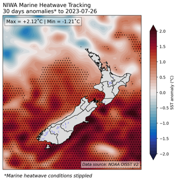
Figure 1: 30-day SST anomalies and marine heatwave conditions (stippled), calculated with respect to the 1991-2020 climatological period.
NZ 30-day coastal SST anomalies (to 26 July)
North NI
+0.27˚C
West NI
+1.11˚C
East NI
+0.88˚C
North SI
+1.26˚C
West SI
+1.02˚C
East SI
+1.82˚C
|
North NI |
+0.27˚C |
|
West NI |
+1.11˚C |
|
East NI |
+0.88˚C |
|
North SI |
+1.26˚C |
|
West SI |
+1.02˚C |
|
East SI |
+1.82˚C |
Forecast Confidence
Temperature
Forecast confidence for temperatures is medium-high. A colder than average three month period is unlikely, due in part to ongoing marine heatwave conditions near the South Island and lower North Island. Increasing westerly winds, associated with El Niño, are forecast to transport warm air masses from Australia at times.
Rainfall
Forecast confidence for rainfall is medium. El Niño is expected to have a growing influence on rainfall patterns in the coming months. More frequent westerly winds will favour low pressure systems crossing the South Island, bringing occasional heavy rainfall to western areas in particular.