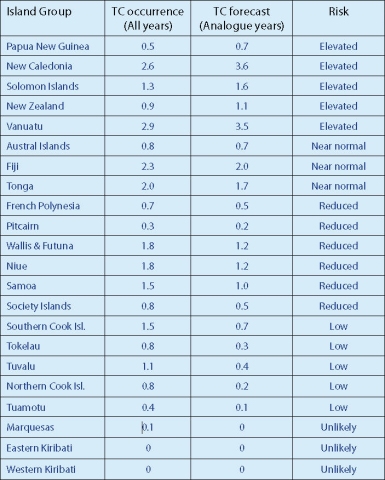
The expectation is that normal or above normal tropical cyclone (TC) activity will occur for most islands west of the International Date Line in the southwest Pacific during the November 2010 – April 2011 season. Although risk is reduced east of the International Date Line, all communities should remain alert and prepared.
Nine to 12 named TCs are expected over the coming season for the southwest Pacific (between 135°E to 120°W). On average, nine tropical cyclones occur each year for the southwest Pacific region. Southwest Pacific TCs are grouped into classes ranging from 1 to 5, with 5 being the most dangerous. For the coming season, three cyclones are forecast to reach at least Category 3, and one system is expected to reach at least Category 4, with mean wind speeds of at least 64 knots or 118 km/h.
Each year, TCs have a significant impact on the southwest Pacific. Places like Vanuatu and New Caledonia typically experience the greatest activity in the region, with an average of about 3 TCs passing close to those countries each year. Projections show an increased risk of TCs for the 2010–11 season over the Coral Sea and to the southwest of Fiji, particularly for Papua New Guinea, the Solomon Islands, Vanuatu, and New Caledonia. New Zealand is also at higher risk of experiencing an ex-tropical cyclone interaction this season. While risk is generally reduced for islands to the east of the International Date Line during La Niña, historical cyclone tracks indicate that TCs can affect parts of southwest French Polynesia, including the Society and Austral Islands, and the Cook Islands during La Niñas. All islands should remain vigilant as the current La Niña continues to evolve with progression into Austral summer. Additional informaton about this forecast and supporting documentation can be found at www.niwa.co.nz. In the Pacific Islands, please contact your local national meteorological service for further information about this guidance.

