
The Centennial Issue of the Island Climate Update: Progress and success resulting from a multi-model ensemble forecast
Andrew Lorrey, Jim Salinger, and James Renwick (NIWA)
The strength of the Island Climate Update (ICU) forecast is drawn from two primary sources: a regional discussion about local climate information by Pacific Island Meteorological Services members each month, and external input from international research organisations which produce forecasts and interpretations of global climate diagnostics. The discussion in the ICU monthly teleconference and the collection of climate models compose the backbone of the ICU three-month forecast. There are more than ten climate models that are used to generate the rainfall outlook for the South Pacific. In 2008, an additional ensemble of SST forecasts, which include six models, were added to the ICU to provide an additional layer of information that could be useful for planning purposes.
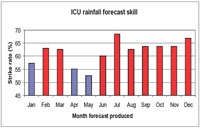
The capability of the ICU multi-model ensemble rainfall forecasts have been tracked for more than eight years now, and there are statistical data indicating when the technique has had good ‘skill’, or the ability to provide accurate climate projections. It is very clear that the ICU has good skill for a majority of the year, and not suprising that the strongest forecast periods are during spring and summer, as well as mid–winter. The period of least skill is during mid–to–late autumn, which corresponds to the time when deterioration of ENSO events typically happens, and as a result the associated strong (as well as predictable) regional climate patterns that accompany these events are diminished.
Many of the island groups in the South Pacific have important spatial contrasts in their rainfall patterns. East–west as well as north–south differences in precipitation anomalies are often observed from month to month. The ICU forecast strike rate statistics indicate that the use of the multi-model ensemble approach to provide an overall rainfall forecast for each island group is, however, better than a coin toss. This suggests the multi-model ensemble approach has value complementary to local forecast information generated by Pacific Island Meteorological Services.
Moreover, the long-term trend in the ICU data indicates that the average strike rate has gradually increased by nearly 10% over the last eight years, at an average rate of about +1% each year. Since the ICU inception in 2000, the practice has been to include additional models that cover the South Pacific region as they come on-line. These additions, along with continual improvements made to models already in use, have likely improved the skill of the regional-scale multi-model ensemble forecast. Key highlights were achieving a global strike rate for the South Pacific of 90% (August–October 2007) and 91% (September–November 2008).
Beginning in 2008, a detailed compilation of the strikerates for the individual global climate models that are used in the ICU was initiated. This was done to assist Pacific Island Meteorological Services in their search for and refinement of the collection of models that could be used for island-specific forecasts. Future training sessions, selection of specific models, and discussions about the multi-model ensemble are anticipated to increase the skill of this powerful approach to regional climate forecasting.
