Estuary origins
How were estuaries created?
In comparison to the vast span of geological time, the estuaries that we see today are very recent coastal features.
In fact, they were formed between 12,000 and 7000 years ago as the sea began to rise at the end of the last ice age. Ice ages occur when the Earth’s climate cools and large areas of land and sea become covered by vast ice sheets. At the peak of the last ice age, many of these ice sheets were several kilometres thick. The remnants of these ice sheets can still be seen today in places such as Antarctica and Greenland.
The Earth has experienced many ice ages in its lifetime. In New Zealand, we call the most recent ice age the Ōtira Glaciation; at its peak, 16–18,000 years ago, the sea was about 120 metres lower than it is today. At that time much of the seabed around the New Zealand coast was dry land and coastal plains extended across what is today the inner continental shelf.

For example, the seabed of the Hauraki Gulf and east coast of the Coromandel Peninsula was a vast plain, across which rivers flowed to the sea beyond what are now offshore islands, such as Great Barrier Island. Marine geologists have collected sediment cores from the bed of the Hauraki Gulf near the Firth of Thames, at a site which is 35 metres below present-day sea level. The sediment cores show that mangrove forests once flourished there in an estuary that last existed about 12,000 years ago. This earlier estuary has long since been flooded by the sea as the ice sheets melted at the end of the last ice age.
In colder regions of New Zealand, such as the lower South Island, rivers of ice called glaciers cut deep valleys out of the rock as they flowed to the sea. All these coastal valleys were flooded by the sea as it rose to its present level about 6500 years ago to form the fiords and the estuaries we know today. These are the same estuaries that your ancestors first saw when they arrived in New Zealand many generations ago.
The estuary life cycle

Stages of estuary life cycle

Stages of estuary life cycle
Like people, estuaries have a natural life cycle, starting in youth and ending in old age. How quickly estuaries age depends on how quickly they fill up with sediment. This has varied from estuary to estuary and mainly depends on the land area (catchment size) draining to the estuary, the amount of soil erosion, the size (volume) of the ancestral estuary, and how much of this eroded soil is trapped.
In their youth, many estuaries are deep basins with open water. Tidal flats build along the shore as land and marine sediments accumulate.
During middle age, these flats become intertidal and more extensive, and are colonised by new communities of plants and animals that can tolerate being exposed to the air at low tide. Sandflats are replaced by mudflats as more fine sediment is delivered to the estuaries following catchment deforestation, as has occurred in New Zealand over the last several hundred years since the arrival of people.
In old age, sediments fill most of the estuary. The often narrow tidal channel is flanked by extensive intertidal flats, which link the land to the sea. These tidal flats are colonised by plants, and freshwater marshes eventually replace saltmarshes in the upper reaches of the estuary.
Think about your own estuary – is it still youthful or has it reached old age?
The average rate of sediment build-up, called the sediment accumulation rate (SAR), was typically less than one millimetre per year before people arrived in New Zealand. This seems like a very small number, but over thousands of years this adds up to a layer of sediment several metres thick deposited in an estuary. Many estuaries with very large catchments in comparison to their own size have almost completely filled with sediment. These eroded catchment sediments (called terrigenous sediments because they come from the land) have built extensive intertidal flats that are exposed at low tide.
One such estuary that has almost completely filled with sediment is the Wharekawa (Coromandel Peninsula), which has a steep catchment that is 50 times larger than the estuary. Like much of the Coromandel, the catchment includes steep hill country that is, from time to time, subject to intense rain storms that erode soils. Estuaries that have reached old age have a limited capacity to trap more sediment. As a result, increasing amounts of eroded catchment sediments are carried out of the estuary to be deposited elsewhere in the coastal environment.
Environmental changes in estuaries - the impacts of people
As we have touched on already, environmental changes in estuaries can occur naturally as well as be the result of people’s activities. Measured over your own lifespan many environmental changes in estuaries may seem to occur very slowly. However, over decades to centuries or more, these incremental changes can completely transform the estuary environment.
Estuary sedimentation is a good example of a natural process that has been affected by the activities of people. Scientists have used sediment cores collected from estuaries and lakes and other evidence to reconstruct the environmental changes that occurred in New Zealand following the arrival of Mäori many centuries ago. The changes in the types of plants growing on the land, as areas of forest were cleared for crops or by accidental fires, are preserved in estuary sediment cores.

Once stripped of its forest cover, the land was vulnerable to soil erosion during heavy rainfall, particularly on steep hills. Much of this eroded soil was deposited in estuaries. The rate of forest removal (deforestation) increased again in many parts of New Zealand when European settlers began to arrive in large numbers in the mid 1800s. Today, only about 25% of the original indigenous forests of New Zealand remain intact. As a result of these large-scale environmental changes, the amount of soil eroded from the land and deposited in estuaries is much higher than before the arrival of people.

During storms, these eroded soils are deposited in estuaries as mud layers. If they are thick enough, the mud layers can smother and bury plants and animals. Some plants and animals can tolerate mud better than others. These mud deposits can also be stirred up again by waves. As a result, our estuaries today are generally muddier and have reduced water clarity in comparison to the past. These issues are discussed in the Sediment and Water Quality modules of this toolkit.
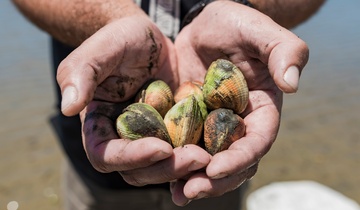
The soils eroded from the land have built the intertidal mudflats and sandflats that are exposed at low tide in your estuary today. In the distant past, these areas were subtidal and always submerged. Intertidal flats are places where you may collect kaimoana. These areas also provided habitats for plants and animals that may not have previously lived in your estuary. Mānawa (mangrove), wīwī (sea rush, saltmarsh plants), and mākaka (saltmarsh ribbonwood) are examples of plants that only grow between the tides on intertidal flats. In some places these plants have replaced other types of plants that lived before the bed of the estuary built up with sediment. One such plant is the karepō (seagrass or eelgrass) that grows on sandflats below mid tide and in areas below tai timu (which are always submerged since tai timu is the low tide level). Tuangi (cockle) are a type of shellfish that live on muddy sandflats between the tides. Your kaumātua and kuia may have noticed these types of changes occurring in your own estuary over their lifetimes.
This module has described the processes that have created the estuaries that we see today. Estuaries are dynamic places that are constantly changing, and the pace of change in many estuaries has increased due to the activities of people. This toolkit, Ngā Waihotanga Iho, will provide you with tools to measure environmental changes in your own estuary.
Glossary of terms
Centuries: a unit of time based on one-hundred-year blocks.
Colonised: the arrival of a plant or animal in a habitat or environment where it did not previously exist.
Continental shelf: the gently sloping undersea area of a continent extending commonly to a depth of about 200 metres at the edge of the shelf.
Decades: a unit of time based on ten-year blocks. For example five decades is equivalent to fifty years.
Deforestation: most commonly refers to the removal of the original indigenous forest from an area of land.
Ice age: a period when temperatures fell worldwide and large areas of the Earth's surface were covered with glaciers.
Intertidal: the area between the high and low tide levels in a coastal zone.
Marine geologist: a type of geologist that studies the sediment processes (e.g., erosion and deposition) and rocks in marine environments.
Sediment accumulation rate (SAR): the average rate of sediment build-up during a given time period. Most often expressed as millimetres per year (mm/yr).
Subtidal: below the low water mark.
Terrigenous: sediment derived from the erosion of land.
Water clarity: how clear the water is. In this toolkit, water clarity is determined by the black disc visibility.