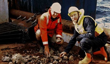
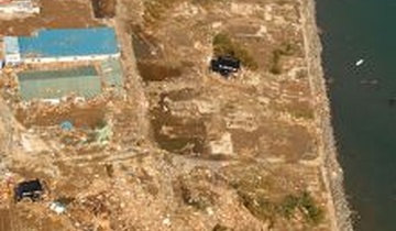
Tsunamis

Latest news

A New Zealand-led team has completed the fullest investigation to date into January’s eruption of the underwater Tongan volcano.
Stacy Mohan looks at how the shockwaves from a remote Tongan island rippled through NIWA’s research community.
New findings from the record-breaking Tongan volcanic eruption are “surprising and unexpected”, say scientists from New Zealand’s National Institute for Water and Atmospheric Research (NIWA).
Innovative experiments are giving natural hazard researchers and PhD students a close look at how erupting volcanoes can cause deadly and damaging tsunamis.

Latest videos

Tonga eruption and tsunami shock the world

Tsunamis and shockwaves hit continents on the other side of the Pacific. The Hunga-Tonga Hunga-Ha'apai (HT-HH) volcano was like a massive shotgun blast from the deep, generating the biggest atmospheric explosion recorded on Earth in more than 100 years. Funded by The Nippon Foundation, NIWA and SEA-KIT surveyed over 22,000km2 surrounding the volcano, including mapping 14,000km2 of previously unmapped seafloor as part of The Nippon Foundation GEBCO Seabed 2030 project. Find out more: https://niwa.co.nz/news/tonga-eruption-confirmed-as-largest-ever-recorded

Mapping the Tongan volcano eruption of Hunga Tonga-Hunga Ha'apai

This important scientific voyage represents a significant opportunity to map the changes in the seafloor and collect samples to understand how the geology, biogeochemistry, and ecosystem health has been impacted. Up until the eruption on 15th January, the volcano caldera sat approximately 150 m below sea level and part of the volcano connected the islands of Hunga Tonga and Hunga Ha'apai. Following the eruption, the islands are smaller and no longer joined together. The scientists are surveying thousands of square kilometres of the seafloor and collecting video images of the eruption’s impact, and using SEA-KIT International’s Uncrewed Surface Vessel (USV) Maxlimer to conduct further mapping. The NIWA-Nippon Foundation Tonga Eruption Seabed Mapping Project (TESMaP) is funded by The Nippon Foundation and also supported by The Nippon Foundation-GEBCO Seabed2030 Project which aims to map the world’s ocean floor by 2030. Follow the voyage here: https://niwa.co.nz/our-science/voyages/2022-tonga-post-eruption

Hazards in the Tasman Sea

Landslides happen in the ocean just like they happen on land and this multi-disciplinary research expedition is looking at what that may mean for the waters off the Taranaki Coast.

Six large-scale slope collapse units (up to 4,000 km3) have been mapped offshore Taranaki-Waikato using 3D seismic data. However, we know very little about these complex processes, which substantially reduces reliability of hazard assessments and thus our preparedness. 

Acquisition of new marine geophysical and sedimentological data is critical to address this knowledge gap and help include submarine landslide-generated tsunami in future New Zealand tsunami hazard assessments.

This project is a collaboration between NIWA, GNS, University of Auckland and University of Newcastle. For more information: https://niwa.co.nz/our-science/voyages/2022-tasman-sea-tsunami

Tracing tsunamis through history

Weaving whakapapa and science together to trace tsunami through history.

NIWA works with Ngati Kuia and Ngati Koata to research oral traditions and physical evidence of past tsunamis on Rangitoto/ D’Urville Island in the Marlborough Sounds.

New Zealand faces a variety of hazards associated with undersea geological activity.
Coastal hazards, driven by more extreme coastal physical processes (including coinciding factors), can cause damage, disruption and even casualties in estuaries, river mouths, open coasts and coastal/shelf waters.
The New Zealand Palaeotsunami Database (Database) brings together all known information about tsunamis that occurred prior to written records.
Understanding how hazards impact people and the environment provides the foundation for informed decision making for a resilient Pacific
Tsunami is a Japanese word meaning great wave in harbour

Targeted geological sampling and imaging by NIWA scientists next week will help understand active seabed processes in one of New Zealand's largest seafloor features.

Coming from the Japanese word 'harbour wave', tsunami are a series of waves – with wave lengths up to hundreds of kilometres between crests - caused by undersea seismic disturbances.
Risks from natural hazards are part of every day life for New Zealanders, whether it is from floods, storms, tsunami, landslides, severe weather or earthquakes.
Tide forecasts, Sea-level network, Tidal model of New Zealand’s EEZ and Red-alert days for coastal flooding

Latest data

NIWA and The Nippon Foundation are undertaking a mission to discover the undersea impacts of the recent Tongan volcanic eruption.

The scientific records of palaeotsunamis to have affected New Zealand shores can now be accessed in a new one-stop information shop.

An exhibition of work NIWA was involved in titled “Shifting Paradigm: The Village of Sa’Anapu, Samoa” was hosted by the National Museum of Samoa this year and is now available in a striking digital presentation.
Shifting Sands - Tsunami hazard off Kaikoura, NZ

Dr Joshu Mountjoy discusses NIWA's work in assessing the tsunami hazard just south of Kaikoura. 

Find out more about this research. 

If the tsunami is local, the best thing to do is to move inland as quickly as possible – if possible, either over 10m above sea level or over 1km inland.

Three new posters of the Cook Strait and Wellington Harbour seabed reveal for the first time a treasure trove of detailed information for the benefit of all New Zealanders.

Pages

All staff working on this subject

placeholder image
Hazard and Risk Analyst
Principal Scientist - Natural Hazards and Hydrodynamics
Strategy Manager - Oceans
Coastal and Estuarine Physical Processes Scientist
placeholder image
Marine Physics Modeller
Principal Scientist - Natural Hazards and Hydrodynamics
Subscribe to RSS - Tsunamis