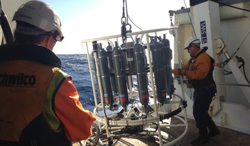
NIWA are studying the ocean off Tairāwhiti and Hawke’s Bay to see how Cyclone Gabrielle has impacted the health of fisheries habitats and seabed ecosystems.
Research conducted after the 2016, 7.8 magnitude Kaikōura earthquake has provided scientists with an extremely rare opportunity to understand the processes that shape submarine canyons.
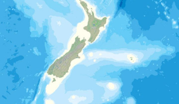
New Zealand’s contribution to an ambitious international project aiming to generate a definitive map of the entire ocean floor in less than 12 years, is being launched in Wellington tomorrow.
Landslides happen in the ocean just like they happen on land and this multi-disciplinary research expedition is looking at what that may mean for the waters off the Taranaki Coast.
Six large-scale slope collapse units (up to 4,000 km3) have been mapped offshore Taranaki-Waikato using 3D seismic data. However, we know very little about these complex processes, which substantially reduces reliability of hazard assessments and thus our preparedness.
Acquisition of new marine geophysical and sedimentological data is critical to address this knowledge gap and help include submarine landslide-generated tsunami in future New Zealand tsunami hazard assessments.
Are you interested in helping map the seafloor? Small data loggers can be used to record information from the positioning (GPS) and echosounding (fish finder) systems of any type of vessel. The Seabed 2030 team can even send a technician to install the device correctly for you.
If you are in the Pacific and keen to be part of a growing community for the Crowdsourced Bathymetry Initiative, please contact: [email protected]
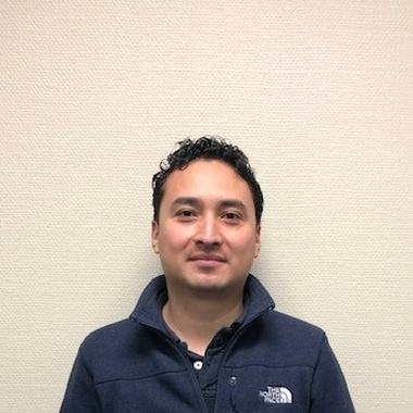
NIWA Marine Acoustician Dr Yoann Ladroit uses multi-beam echo sounders to map the bathymetry around Whakaari/White Island very quickly and with pinpoint precision.
Yoann is also leading research into using acoustics to find underwater gas bubble flares and then compare these to the chemical composition of water samples taken at the same locations.
NIWA are studying the ocean off Tairāwhiti and Hawke’s Bay to see how Cyclone Gabrielle has impacted the health of fisheries habitats and seabed ecosystems.
Landslides happen in the ocean just like they happen on land and this multi-disciplinary research expedition is looking at what that may mean for the waters off the Taranaki Coast.
Six large-scale slope collapse units (up to 4,000 km3) have been mapped offshore Taranaki-Waikato using 3D seismic data. However, we know very little about these complex processes, which substantially reduces reliability of hazard assessments and thus our preparedness.
Acquisition of new marine geophysical and sedimentological data is critical to address this knowledge gap and help include submarine landslide-generated tsunami in future New Zealand tsunami hazard assessments.
Are you interested in helping map the seafloor? Small data loggers can be used to record information from the positioning (GPS) and echosounding (fish finder) systems of any type of vessel. The Seabed 2030 team can even send a technician to install the device correctly for you.
If you are in the Pacific and keen to be part of a growing community for the Crowdsourced Bathymetry Initiative, please contact: [email protected]
NIWA Marine Acoustician Dr Yoann Ladroit uses multi-beam echo sounders to map the bathymetry around Whakaari/White Island very quickly and with pinpoint precision.
Yoann is also leading research into using acoustics to find underwater gas bubble flares and then compare these to the chemical composition of water samples taken at the same locations.
During the TAN2007 voyage NIWA scientists headed to the waters around Whakaari/White Island in the Bay of Plenty to survey changes to the seafloor since the volcanic eruption in December 2019. They surveyed the chemical composition of gases released by the hydrothermal vents on what is known as the Calypso vent field in the Bay of Plenty.
Combining multibeam bathymetry, specialist GIS software and high-resolution camera footage, NIWA has produced startlingly vivid three-dimensional photo-mosaics of undersea habitats.
NIWA is leading a New Zealand partnership to map the South and West Pacific Ocean's seabed as part of a worldwide initiative to map the entire globe’s seafloor.
Research conducted after the 2016, 7.8 magnitude Kaikōura earthquake has provided scientists with an extremely rare opportunity to understand the processes that shape submarine canyons.
New Zealand’s contribution to an ambitious international project aiming to generate a definitive map of the entire ocean floor in less than 12 years, is being launched in Wellington tomorrow.
Hull-mounted on the RV Tangaroa, the EM302 multibeam echosounder maps the seafloor using a fan of 288 acoustic beams, producing up to 864 soundings per ping in dual swath mode, providing 100% coverage of the seabed.
The findings of the most complex underwater coastal survey of the seafloor undertaken in New Zealand, including previously undiscovered natural features and sunken boats, are to be formally presented to the Marlborough community tomorrow.