
The submarine metropolis of Brittlestar City


Millions of small dark brown brittlestars, tentatively identified as Ophiacantha otagoensis, cover the flat summit of the seamount. (Photo: DTIS TAN0803)

Waving for a meal: Ophiacantha rosea capture plankton and zooplankton from the passing current in mucus on the feathery spines on their arms. (Photos: DTIS TAN 0803

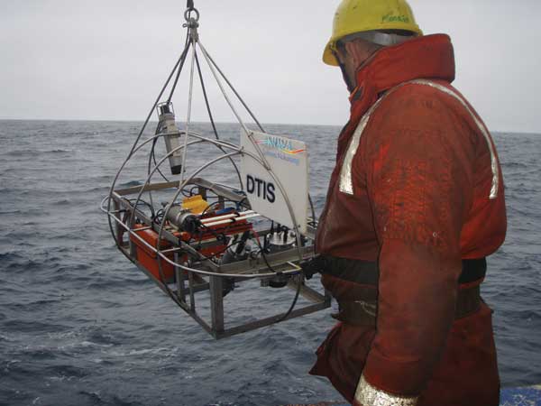
The DTIS is winched over the side as it sets off on another run through the depths. (Photo: Julian Finn, Museum Victoria)
One of the deck crew guides the DTIS over the side. (Photo: Julian Finn, Museum Victoria)

At the control centre, scientists are thrilled to see Brittlestar City appearing on screen from the live video feed. (Photo: Julian Finn, Museum Victoria)

The DTIS, retrieved from a ‘flight’. (Photo: David Bowden)
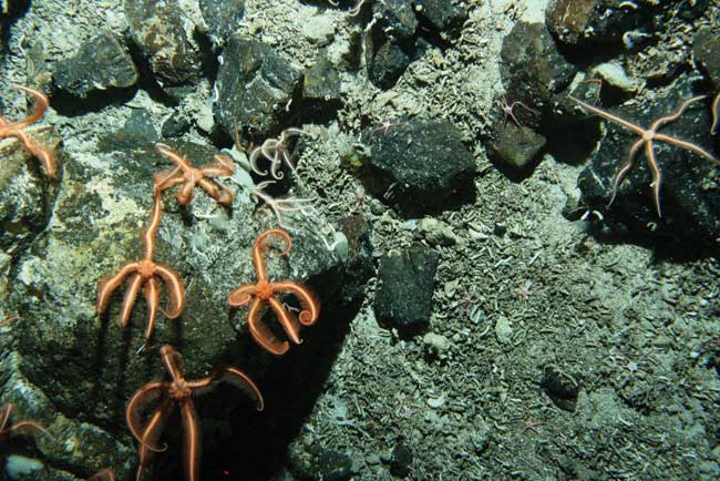
Ophiacantha rosea, the brittlestar species that carpets the sides of the seamount. (Photo: DTIS TAN 0803)

Inset map shows the position of Macquarie Ridge, extending south from New Zealand. The orange star marks the site of Brittlestar City. (Maps: Simon Bardsley)

The SM6 seamount lies about 90 m deep and rises about 760 m above the seafloor. (Graphic: Arne Pallentin and Simon Bardsley)
Mireille Consalvey and Peter Hill describe one of the most exciting finds of a recent voyage down the Macquarie Ridge.
To appreciate the most dramatic of the world’s cities, we raise our eyes to the skyline. But last April a team of marine scientists aboard RV Tangaroa looked down and discovered a new city. For the first time scientists saw the new metropolis, sitting atop a seamount taller than the world’s highest building and crossed by the superhighway that is the Antarctic Circumpolar Current. They nicknamed it Brittlestar City.
The discovery was one of a number made during a month-long Tangaroa voyage down the Macquarie Ridge. The ridge stretches 1400 km south along the ocean floor from New Zealand to just above the Antarctic Circle and runs through both New Zealand and Australian waters. This voyage was a joint New Zealand and Australian venture and brought together biologists, physicists, and geologists from NIWA, GNS Science, CSIRO, Antarctic Climate & Ecosystems Cooperative Research Centre (ACE CRC), Museum Victoria, and the Australian National University; 20 scientists and technicians were supported by 15 crew.
A word from the mayor
If Brittlestar City were a real city, then the mayor would likely be Dr Tim O’Hara, curator of marine invertebrates at Australia’s Museum Victoria. A world expert in brittlestar taxonomy and ecology, Tim was on hand back on land to receive the first images of the seabed animals.
“Brittlestars (opiuroids) are members of the echinoderm phylum,” says Tim. “They have five arms like their relatives the seastars, but they’re more agile. There are more than 2000 brittlestar species that live at all depths in all the world’s oceans and, with no eyes and no brain, they are a simple but very effective eating machine. Brittlestars have been common since dinosaurs roamed the earth (in the Mesozoic era) and fossil remains indicate that they occurred in dense aggregations in shallow seas in the Palaeozoic – that was, until the evolution of the predatory bony fish.”
Using images from NIWA’s deep-towed imaging system (DTIS), Tim was able to confirm that two species rule this city. On the summit, living arm tip to arm tip, were small dark brown brittlestars, probably Ophiacantha otagoensis, a species only known to exist in New Zealand. As the DTIS descended the seamount, the neighbourhood changed and the main occupant became a larger red-orange species, Ophiacantha rosea, filmed waving their arms in the current.
Location, location, location
Aside from the dramatic spectacle of millions of brittlestars carpeting the seamount’s 100-km2 flat top, what makes this discovery exciting is that seamount peaks are usually dominated by corals and sponges. This discovery is one of the first records of brittlestar domination on a seamount.
These stay-at-home brittlestars gather food from passing currents. Extending their arms upwards into the water, the brittlestars use mucus on their spines and tube feet to collect plankton and then roll it into their mouths, located in the middle of the body under the central disc.
Marine physicists were on board the voyage to study the Antarctic Circumpolar Current in greater detail (ACC), and Dr Mike Williams explains that water currents were racing over the summit at speeds reaching 4 km per hour. Tim and the biologists on board hypothesise that these currents enable the huge brittlestar population, providing plenty of food as well as protection from fishy predators that are unable to hover over the area. It will be some time, however, until scientists fully understand life in Brittlestar City.
World famous in New Zealand – and beyond!
News of the discovery of Brittlestar City quickly spread around the world. It appeared in print in 26 countries in 7 languages, and within a few months it featured on hundreds of websites ranging from National Geographic to UnderwaterTimes.com to Echinoblog. The CenSeam website profiled the voyage through daily ship-to-shore logs and Q&A sessions with Nelson College for Girls: class 9St provided the questions and the scientists onboard supplied the answers.
Flying to Brittlestar City on the DTIS
The metropolis lies hundreds of metres below the sea surface, in accessible to most humans; the journey to Brittlestar City was made possible by NIWA’s deep-towed imaging system – DTIS. Designed by Peter Hill, and capable of descending to 6 km, DTIS is an underwater vehicle housing a still camera and a high-resolution video camera. Real-time slow-scan video, depth, and altimeter data are transmitted up the tow cable while full-speed high-resolution video is recorded onto tape underwater.
Piloted by Tangaroa’s deck crew, the DTIS is skillfully ‘flown’ 2–3 m above the bottom by winching cable in and out. Meanwhile, officers in the bridge have the difficult task of keeping Tangaroa on track despite often contrary winds and shear currents in the water, and all the while ensuring that the tow cable does not pass under the vessel.
Simultaneously, in the DTIS control centre, scientists monitor the live video feed. As they watch the sun-filled, light-blue water gradually fade toa deep indigo and then to black, anticipation builds. An onboard altimeter senses when the seafloor is close and the video lights turn on. All eyes are peeled to catch the first sight of the seafloor.
Flying the DTIS along the seafloor for 60 minutes at a stretch requires a concentrated effort and teamwork with the ever-present risk of collision or entanglement with the rugged seafloor. At the end of the run there’s a visible relaxing of tension; the order is given to haul up, the video lights and cameras are turned off, and the DTIS is lifted safely away from danger.
Back on deck, a small ‘pitstop’ crew swarms over the vehicle: they take the video camera into the laboratory to change the tape, download still camera images, recharge batteries, and back-up data. Soon the DTIS is ready to descend again.
The ACC superhighway
The main oceanographic aim of the voyage was to determine how the Antarctic Circumpolar Current interacts with the Macquarie Ridge.
The ACC is the world’s largest current: every second it transports about 135 million m3 of water - or 135 times the water in all the world’s rivers.
The ACC is able to transport these large amounts of water because the Southern Ocean is both deep (typically around 4 km) and broad, so there is little resistance to the flow. When it comes into contact with the Macquarie Ridge (or any submarine ridge), the water is steered through the gaps within the ridge. These gaps provide us with an opportunity to accurately measure how much water is in the different branches, or fronts, of the ACC, and how they vary over time.
On a voyage in 2007 we established nine oceanographic moorings across two gaps in the ridge. The mooring lines were hung with instruments that have been measuring the speed and direction of the flow through the gaps over the last year. We also measured the temperature and salinity of the ocean along the ridge and in the two gaps. The temperature and salinity of a parcel of water provide a signature identifying where the water comes from. To complement these measurements, during the voyage an instrument called an acoustic current doppler profiler (ADCP), mounted on the hull of the ship, constantly measured the current speeds in the water under the ship.
It was through these various measurements that the scientists on board Tangaroa were able to estimate the speed of the currents whipping past Brittlestar City.
Teachers’ resource for NCEA Achievement Standards or Unit Standards:
Biology Level 3 AS90716, US8933
Science Level 2 AS90771, AS90772