Southern Ocean seas and atmosphere
The Southern Ocean is under-sampled. Data collected continuously during the Antarctic Ecosystems Voyage helped fill an important knowledge gap about oceanographic and atmospheric processes in this important region.
Overview
This research aimed to provide data to contribute to better global climate and oceanographic models. These models can help improve weather forecasting, and help scientists understand how climate change affects the Southern Ocean. Data also provided a physical context for biological observations made under other objectives of the voyage.
There were 2 primary programmes – the oceanographic and atmospheric programmes.
The oceanographic programme had 4 parts:
- collection of data while on the voyage and moving (ie underway)
- focused sampling of the upper water column sampling, using an underway Conductivity, Temperature and Depth profiler (CTD)
- deployment of Argo floats and surface drifters
primary productivity experiments on board.
The atmospheric programme focused on improving our knowledge of clouds and aerosol-cloud interaction processes over the Southern Ocean. This will help guide and improve future climate predictions.
Approach
Tangaroa’s underway flow-through system
We collected surface water using a seawater intake in the ship’s hull. This water was sent through a series of inline electronic instruments to measure:
- sea surface temperature
- conductivity (salinity)
- dissolved oxygen
optical properties
dissolved carbon dioxide (pCO2).
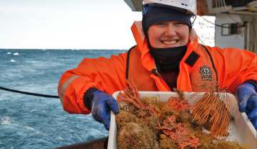
We also took water from the intake system and used it for chemical analysis and primary production – how much algae is growing in the sea - experiments on board.
Sampling with an underway CTD
We used a freefalling instrument from on board Tangaroa. This was later auto-recovered. We conducted the sampling while the ship was moving (ie underway), which allowed us to collect data without slowing us down.
Argo floats
Argo floats are autonomous instruments that collect oceanographic information and send it back via satellite.
During the voyage, we deployed 12 Argo floats in the Southern Ocean while in transit to and from the Ross Sea. This contributed to the international Argo programme’s focus on maintaining global coverage of the oceans.
The programme aims to deploy an array of 3,000 to 4,000 Argo floats in the world's oceans. They provide real-time observations of temperature and salinity in the upper layer of the world’s waters.
The floats typically drift at a depth of 1-2km. They rise to the surface every 10 days, measuring temperature and salinity changes as they go. After they send their data and location to scientists via satellite, they sink again to begin another cycle.
Read more about our involvement in the Argo programme
Atmospheric chemistry sampling
We used a variety of techniques on board for atmospheric sampling, These included:
- continuous sampling of air pumped to atmospheric monitoring equipment
- collection of discrete gas and aerosol samples into flasks or on filters
- low-power lidar 'sounding' of the atmosphere.
Lidar (also written LIDAR, LiDAR or LADAR) is a remote sensing technology. It measures how far away something is by shining a laser at the target and measuring the light that gets reflected. This allows scientists to make direct measurements of the altitude, depth and base of cloud layers, in a region where only satellite measurements previously existed.
We also explored cloud processes in collaboration with colleagues in the USA. Scientists there are trying to answer the question ‘why doesn’t it snow as much as we expect in the Southern Ocean?’ This voyage was the first in 30 years to investigate ice nucleation particles from the air, and study the ice nucleating particles found in, and released by, seawater. The research will be an important source of uncertainty in modelling cloud behaviour and the radiation balance of the oceans.
We collected flask samples of air to measure the radiocarbon content of carbon dioxide above the Southern Ocean. This allows us to improve our knowledge of the processes that drive carbon dioxide exchange between the air and the ocean.
Results
The 2015 Antarctic Ecosystems Voyage will continue to inform several important research programmes.
Results of the activity on the voyage include:
- nearly 1,000 hours of continuous underway oceanographic and atmospheric data collection
- over 3,500 litres of seawater filtered
- 33 experiments on board to measure primary production
- 55 conductivity-temperature-depth (CTD) profiles collected underway
- 12 Argo oceanographic floats and 10 surface drifters deployed
- 10 continuous plankton recorder (CPR) deployments.
Read about atmospheric gas analysis
Read about global climate and ocean models
Related information
Contact