The weather’s better in lockdown, right?
A record-equalling top temperature of 23ᵒC in Akaroa on Tuesday prompted a feeling of déjà vu for NIWA forecaster Ben Noll.
It was warmer than normal and the country was in lockdown – it got him wondering whether the weather was always better in Level 4.
Mr Noll roped in NIWA data scientist Neelesh Rampal to help crunch the numbers and sure enough, the number of dry days and the temperatures were higher in Level 4 lockdown for March and April last year, and now for August this year.
While the analysis could be said to be more coincidental than scientifically remarkable, Mr Noll confirms that on average, lockdown days have featured more high pressure around New Zealand and particularly west of the country, encouraging more settled conditions.
“The sample size of about 40 days isn’t nearly long enough to say anything specific about trends, but it represents an interesting data point that might be more noticeable since we’re all spending more time indoors.”
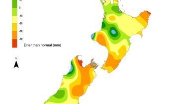
As for where this lockdown phenomenon is being felt the most, warmer than average days have been happening across the North Island, the top of the South Island and about Otago.

Dry days (days with less than 1 mm of rain) have been common during level 4s past and present, especially in the North Island and eastern South Island.
This includes Otago, Canterbury, eastern Marlborough, Nelson, Wairarapa, Hawke’s Bay, Gisborne, Bay of Plenty, eastern Waikato, and parts of Auckland and Northland.
Looking ahead, Mr Noll said that there will be a spell of wet weather from tomorrow into early next week. Beyond that, he saw a return to tranquility.
“During September, patterns of high pressure may again dominate, bringing increased sunshine and below normal rainfall to swathes of the country. Temperatures in eastern areas could reach 20-25 degrees at times.”
If we’re basing lockdown on the weather, we may be here for a while.