A weekly update describing soil moisture across the country to help assess whether severely to extremely dry conditions are occurring or imminent. Regions experiencing these soil moisture deficits are deemed “hotspots”. Persistent hotspot regions have the potential to develop into drought.
A powerful and persistent ridge of high pressure over much of New Zealand during the second half of November caused near-record or record dryness in some locations and has led to the depletion of soil moisture levels with plants in some areas in the lower North Island and South Island approaching their wilting points.
Some Statistics on November’s Dryness:
|
|
Total rainfall (1-29 Nov) |
November ranking |
|
Orari Estate |
0.0 mm |
Tracking for driest on record since records began in 1897 |
|
Lincoln |
0.4 mm |
Tracking for driest on record since records began in 1881 |
|
Christchurch (Airport) |
1.4 mm |
Tracking for driest on record since records began in 1863 |
|
Ashburton |
6.0 mm |
Tracking for driest on record since records began in 1909. |
|
Oamaru |
6.2 mm |
Tracking for driest on record since records began in 1941 |
|
Waimate |
8.2 mm |
Tracking for driest on record since records began in 1898 |
|
Hanmer Forest |
10.8 mm |
Tracking for driest on record since records began in 1905 |
|
Levin |
15.6 mm |
Tracking for driest on record since records began in 1895 |
|
Wellington (Kelburn) |
17.2 mm |
Tracking for 3rd driest on record since records began in 1928 |
|
Auckland (Airport) |
17.8 mm |
Tracking for 2nd driest on record since records began in 1948 |
|
Puysegur Point |
61.8 mm |
Tracking for driest on record since records began in 1959 |
With the final day of November looking dry across many of these locations, it is likely that many of the statistics above will become new records. Please find these in NIWA’s November Climate Summary to be released 5th December.
Facts: Soil Moisture
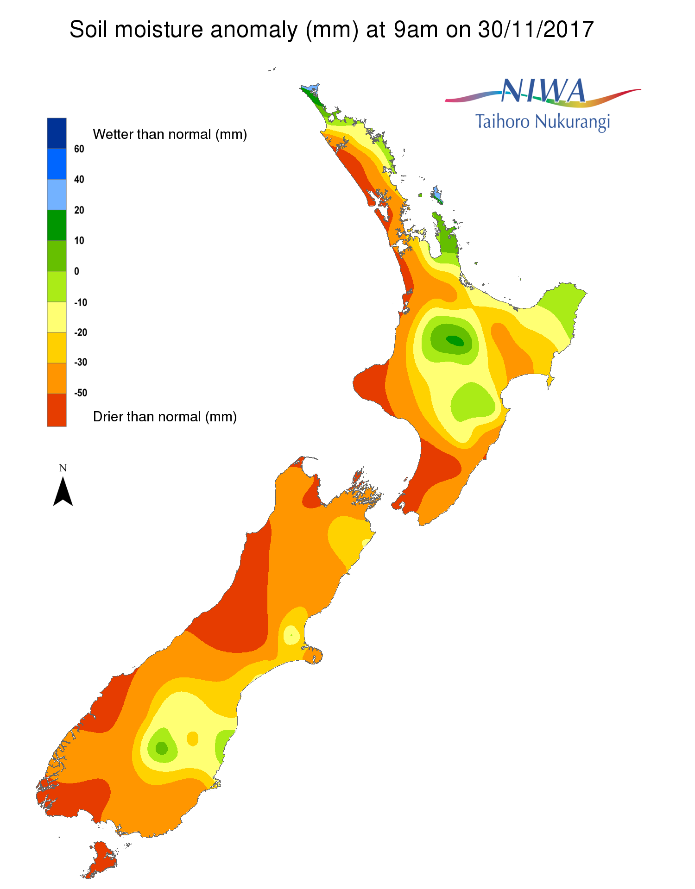
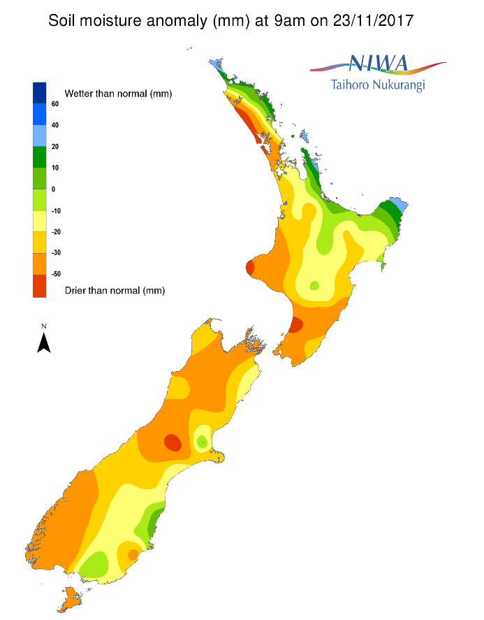
Across the North Island, soil moisture levels have generally decreased over the past week. Soil moisture levels have subtly increased across the Central Plateau. The driest soils across the North Island compared to normal for this time of year are found in the Kaipara District, Taranaki, and in Horowhenua, Kapiti Coast, and Porirua while the wettest are in the upper Coromandel Peninsula.
Hotspots in the North Island are found in the Kaipara District, northern Auckland, across Hawke’s Bay, and in parts of southern Manawatu-Whanganui. Over the past week, hotspots have developed in parts of southern Auckland and northern Waikato, as well as Wellington-Wairarapa.
Across the South Island, soil moisture levels have generally decreased over the past week except for a small increase in Central Otago due to thunderstorm activity. The driest soils across the South Island compared to normal for this time of year are found in Westland, interior mid-Canterbury, Tasman, western Southland, and in Stewart Island while the wettest are in Otago.
Isolated hotspots are in the northern Marlborough and Tasman Districts as well as across interior middle and southern Canterbury and the Clutha District. Over the past week, hotspots have developed in upper Canterbury and Southland.
Outlook and Soil Moisture
A strong ridge of high pressure is forecast to be the main weather feature across New Zealand over the next week, leading to continued dry and settled weather for the most part.
For the North Island, Friday will have a few showers and thunderstorms across the Central Plateau, Gisborne Ranges, Taranaki, interior Manawatu-Whanganui, Waikato, Auckland, and western Northland generally totalling 10 mm or less but up to 25 mm possible in any thunderstorm. Saturday will have more isolated afternoon showers and thunderstorms delivering similar rain amounts to Friday but covering much of the central and eastern part of the island.
Sunday through Friday appear predominantly dry and very warm with any isolated shower or thunderstorm activity impacting mainly the ranges. Heading into next weekend, a front may bring some rain to western and northern parts of the island.
Because of significantly below normal rainfall, soil moisture levels are expected to decrease notably over the next week. Building hotspot activity is likely across much of the island. Plants in areas across the lower North Island may be at or approaching their wilting point due to continued dryness.
In the South Island, isolated showers and thunderstorms will affect parts of Otago, Southland, the West Coast, and Tasman and Marlborough on Friday. Totals will generally be less than 10 mm, though up to 25 mm is possible in any thunderstorm. On Saturday, most places will be dry except for Fiordland where 5 to 15 mm of rain is possible. Generally dry weather, except for Fiordland where light rain amounts will fall, is expected Sunday through Tuesday. Dry on Wednesday and Thursday, then rain in the western South Island and a few showers in the east possible from Friday into next weekend.
Over the next week, rainfall is expected to be below or much below normal. Soil moisture levels are likely to decrease island-wide. Building hotspot activity is likely and plants in parts of the west and south of the island may be at or approaching their wilting point due to continued dryness.
Background:
Hotspot Watch: a weekly advisory service for New Zealand media. It provides soil moisture and precipitation measurements around the country to help assess whether extremely dry conditions are imminent.
Soil moisture deficit: the amount of water needed to bring the soil moisture content back to field capacity, which is the maximum amount of water the soil can hold.
Soil moisture anomaly: the difference between the historical normal soil moisture deficit (or surplus) for a given time of year and actual soil moisture deficits.
Definitions: “Extremely” and “severely” dry soils are based on a combination of the current soil moisture status and the difference from normal soil moisture (see soil moisture maps)