NIWA's Hotspot Watch for 26 October 2017
A weekly update describing soil moisture across the country to help assess whether severely to extremely dry conditions are occurring or imminent. Regions experiencing these soil moisture deficits are deemed “hotspots”. Persistent hotspot regions have the potential to develop into drought.
Facts: Soil Moisture
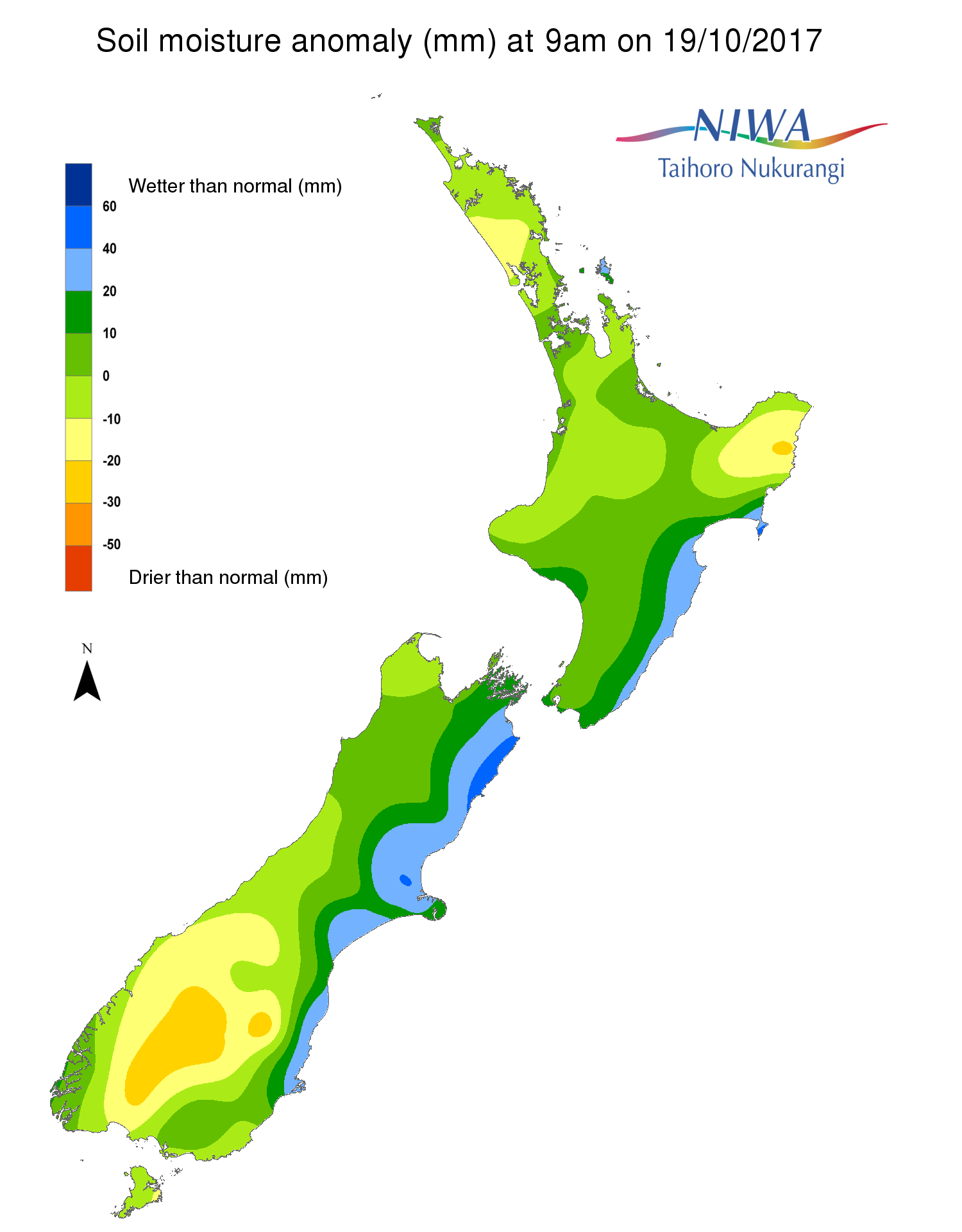
Across the North Island, soil moisture levels have generally not changed significantly during the past week. Minor soil moisture increases occurred across northern Waikato and Auckland, along with Northland’s Far North District. Meanwhile, soil moisture decreases were observed across Gisborne, interior Bay of Plenty, much of Waikato, Taranaki, and parts of Hawke’s Bay and Wellington. The driest soils across the North Island compared to normal for this time of the year are found in Gisborne, while the wettest soils for this time of the year are located around Cape Reinga and coastal Hawke’s Bay.
There are currently no hotspots located in the North Island.
Across the South Island, soil moisture levels have generally decreased during the past week. This is most evident across interior Otago, much of Southland, and lower Westland, where a long-term dry spell finally broke on Wednesday. In fact, Queenstown’s dry spell reached 30 days, its longest since a 33-day dry stretch in February-March 2013. Smaller soil moisture decreases also took place across upper Tasman, Nelson, and Marlborough. Meanwhile, minor soil moisture increases occurred in northern Westland. The driest soils across the South Island compared to normal for this time of the year are found in interior Otago and Southland, while the wettest soils for this time of the year are found along the eastern coast from Kaikoura to Dunedin.
The hotspot located in parts of Central Otago and Waitaki has slightly increased in size and strength during the past week.
Outlook and Soil Moisture
For the North Island, a large area of high pressure setting up east of New Zealand will preclude significant rainfall from occurring in most locations. The one exception could be on Friday (27th October), as a front could deliver a quick 10-20 mm across Taranaki, Waikato, and Manawatu-Whanganui, with slightly higher amounts possible in Bay of Plenty. Similar locations could receive an additional 5 mm or so from showers on Sunday. However, primarily dry weather is expected across the North Island next week as high pressure will be in control. During the next week, many locations across the upper and lower North Island may only receive rainfall totals of 5-15 mm.
With low rainfall amounts expected to fall across the upper and lower North Island during the next week, soil moisture levels are expected to decrease in these areas, while soil moisture levels are not expected to change significantly in the central North Island. The dry areas in Gisborne and Kaipara District may worsen during the next week, but hotspots are not expected to form.
For the South Island, only meagre rainfall is anticipated during the next week as high pressure will dominate the weather pattern. Isolated showers may move across the upper South Island and West Coast at times, but total rainfall is likely to remain below 15 mm. Next Thursday (2nd November), a few showers may bring less than 10 mm to Southland. However, across Canterbury and Otago, total rainfall could remain below 5 mm, with isolated locations seeing no rainfall at all.
Due to minimal rainfall, soil moisture levels are likely to decrease almost everywhere in the South Island during the next week. This will allow the hotspot in Central Otago and Waitaki to strengthen and increase in size across interior Otago and southern Canterbury. However, no additional hotspots are expected to form during the next week.

Background:
Hotspot Watch: a weekly advisory service for New Zealand media. It provides soil moisture and precipitation measurements around the country to help assess whether extremely dry conditions are imminent.
Soil moisture deficit: the amount of water needed to bring the soil moisture content back to field capacity, which is the maximum amount of water the soil can hold.
Soil moisture anomaly: the difference between the historical normal soil moisture deficit (or surplus) for a given time of year and actual soil moisture deficits.
Definitions: “Extremely” and “severely” dry soils are based on a combination of the current soil moisture status and the difference from normal soil moisture (see soil moisture maps)