A weekly update describing soil moisture across the country to help assess whether severely to extremely dry conditions are occurring or imminent. Regions experiencing these soil moisture deficits are deemed “hotspots”. Persistent hotspot regions have the potential to develop into drought.
Facts: soil moisture
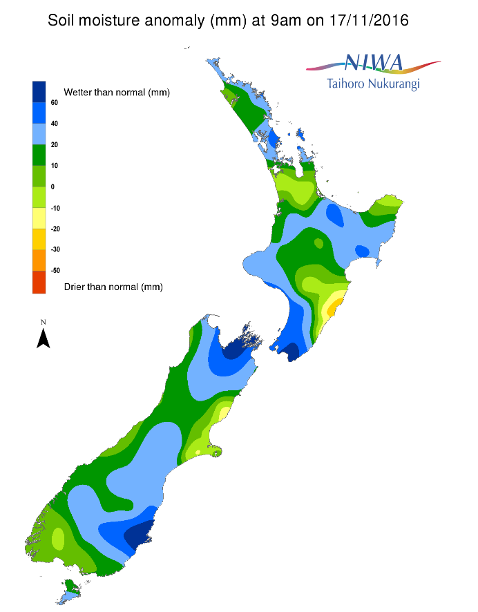
Across the North Island soil moisture levels have exhibited little change compared to this time last week. However, just a small decrease in east coastal Manawatu-Whanganui (Tararua) has resulted in the development of a small hotspot.
Small decreases were also observed across northeastern Gisborne and in the Waikato. The driest soils across the North Island compared to normal for this time of the year are found in the Tararua and Central Hawke’s Bay districts (where a hotspot now exists), while the wettest soils for this time of the year are found in the Wellington region.
Across the South Island, soil moisture levels have shown little change compared to this time last week. A small decrease was observed in the Tasman and Marlborough regions. The driest soils in the South Island compared to normal for this time of the year are still found in northern Canterbury, though soil moisture has trended significantly toward normal in recent months. The wettest soils for this time of year are found in coastal Otago.
Outlook and soil moisture
The North Island will have several rounds of locally heavy rainfall over the next week. Areas that have already received more than their normal November rainfall, particularly across the central and lower portion of the island, will continue to build on a very wet month.
A band of soaking rain will move across western, central and northern areas early on Friday. Amounts will be locally heavy (25 to 50 mm), especially across the central Plateau and parts of the lower North Island where rainfall has been above or well above normal this month. Rainfall is expected to be a bit lower across the northern North Island, where a general 10 to 20 mm is expected through midday Friday. Meanwhile, most of the eastern North Island will only see light showers with rainfall on the order of 5 mm or less. On Saturday, showers will once again target the western side of the island with a general 5 to 15 mm of additional rainfall. A heavier round of rain is possible on Sunday, giving another 25 to 50 mm to the central North Island. Lighter amounts between 5 and 15 mm are expected across the lower North Island early on Sunday. In addition, rainfall of generally 10 mm or less is expected across the northern and eastern North Island on Sunday.
Showers are expected to continue across the lower and central North Island Monday, though it isn’t expected to be nearly as wet as the previous 3 days with less than 5 mm expected. Of any day of the week, Tuesday may be the most likely to be dry across the North Island before more showers potentially affect the lower and central island on Wednesday and Thursday. Patches of unsettled weather are expected to continue through to the end of next week, with the most substantial rains continuing to target the already wet central and lower North Island.
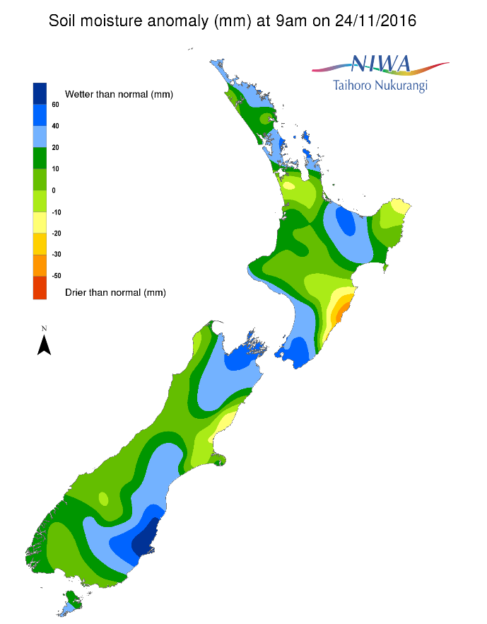
Over the next week, the one hotspot in the Tararua and Central Hawke’s Bay districts may remain the same or expand slightly to the north. Expansion toward the south is not expected. Hotspot development is not expected elsewhere on the island. Rainfall in the central portion of the island is expected to be above or well above normal, which will lead to increased soil moisture.
Over the next week, active weather is also expected across the South Island. While the heaviest rains are expected to be found along the West Coast, some spill-over rainfall is expected along the east coast.
On Friday, heavy rain will develop from the upper West Coast through to Fiordland, continuing through Saturday before easing on Sunday. Rainfall through Sunday is forecast to be on the order of 50 to 200 mm (in the highest elevations). For eastern Southland and Otago, falls of 10 to 25 mm are possible through Sunday while the remainder of the east coast receives less than 10 mm. Isolated showers are expected to continue on Monday in the south and west with most totalling less than 10 mm. Tuesday through Wednesday, another band of locally heavy rainfall will aim for the West Coast with lighter falls in the south and east. Thursday may bring the best opportunity for dry weather all week before another weather system moves through on Friday (2nd December), once again targeting the West Coast most directly.
No official hotspots are expected to develop in the South Island over the next week. Soil moisture will likely remain the same or increase in most areas.
Background
Hotspot Watch a weekly advisory service for New Zealand media. It provides soil moisture and precipitation measurements around the country to help assess whether extremely dry conditions are imminent.
Soil moisture deficit: the amount of water needed to bring the soil moisture content back to field capacity, which is the maximum amount of water the soil can hold.
Soil moisture anomaly: the difference between the historical normal soil moisture deficit (or surplus) for a given time of year and actual soil moisture deficits.
Definitions: “Extremely” and “severely” dry soils are based on a combination of the current soil moisture status and the difference from normal soil moisture (see soil moisture maps).