NIWA's Hotspot Watch for 23 November 2017
A weekly update describing soil moisture across the country to help assess whether severely to extremely dry conditions are occurring or imminent. Regions experiencing these soil moisture deficits are deemed “hotspots”. Persistent hotspot regions have the potential to develop into drought.
A large ridge of high pressure, influenced by La Niña conditions, has taken shape over New Zealand during the second half of November. This has led to predominantly dry and very warm conditions across the country and, consequently, many locations are tracking for either their record driest or near-record driest November.
Some statistics on the unfolding dryness:
|
|
Total rainfall (1-22 Nov) |
Normal November rainfall |
November ranking |
|
Christchurch (Airport) |
1.4 mm |
46.3mm |
Tracking for driest on record since records began in 1863 |
|
Lincoln |
0.4 mm |
48.6mm |
Tracking for driest on record since records began in 1881 |
|
Oamaru |
6.2 mm |
42.4mm |
Tracking for driest on record since record began in 1941 |
|
Auckland (Airport) |
17.8 mm |
71.7mm |
Tracking for 2nd driest on record since records began in 1959 |
|
Wellington (Kelburn) |
17.2 mm |
74.8mm |
Tracking for 3rd driest on record since records began in 1928 |
Facts: Soil Moisture
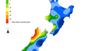
Across the North Island, soil moisture levels have generally decreased over the past week. However, an increase in soil moisture was observed in East Cape and in east coastal Northland. The driest soils across the North Island compared to normal for this time of year are found in western Kaipara, South Taranaki, and in Horowhenua while the wettest are in East Cape.
Hotspots in the North Island are found in the Kaipara District, northern Auckland, across Hawke’s Bay, and in coastal Manawatu-Whanganui. The hotspot in Gisborne dissipated due to rain during the last week.
Across the South Island, soil moisture levels have decreased over the past week. The decreases were most prevalent in Southland, along the West Coast, as well as in middle and upper Canterbury. The driest soils across the South Island compared to normal for this time of year are found in interior mid-Canterbury and the wettest are in coastal Otago.
The hotspot previously located in Central Otago and Waitaki has dissipated due to the heavy rainfall earlier this week.
Isolated hotspots are located in the northern Marlborough and Tasman Districts as well as across interior middle and southern Canterbury. A small hotspot has developed in the Clutha District.
Outlook and Soil Moisture
While a large ridge of high pressure is expected to generally remain anchored over the country over the next week, a few weak disturbances and sea breeze convergence may lead to isolated showers and thunderstorms.
For the North Island, mostly dry weather is expected on Friday. On Saturday, isolated showers totalling 5 mm or less are possible in the central Plateau, Gisborne and Bay of Plenty ranges, as well as the Coromandel. On Sunday and Monday, isolated showers and thunderstorms are possible across the lower and central North Island with amounts generally less than 10 mm but up to 25 mm in the odd thunderstorm. On Tuesday and particularly Wednesday, isolated showers and thunderstorms are possible across the central and upper portion of the Island with amounts generally 10 mm or less but up to 25 mm in a thunderstorm. The risk for daily afternoon spotty showers and thunderstorms will continue Thursday and Friday with similar rain amounts expected. At this point, mostly dry conditions are favoured next weekend although a weak sub-tropical disturbance forecast to track near the upper North Island bears watching.
Rainfall over the next week will be patchy in nature, with some areas receiving normal or even above normal rainfall while others receive only light amounts. Because of this, soil moisture levels may remain the same or increase in areas like the central North Island but decrease across the coastal eastern North Island and in the south-west. Over the next week, building hotspot activity is most likely from coastal Manawatu-Whanganui into Taranaki and from coastal Gisborne and Hawke’s Bay into the Wellington-Wairarapa region.
For the South Island, afternoon showers will dot the ranges on both Friday and Saturday with rainfall generally totalling 5 mm or less, though up to 15 mm across interior Southland. On Sunday afternoon, shower and thunderstorm activity will be a bit more widespread across the interior South Island with generally less than 10 mm but up to 25 mm in any thunderstorm. Amounts will be similar on Monday and Tuesday, but showers and thunderstorms are forecast to be less numerous than Sunday. Daily, isolated showers and thunderstorms are expected from Wednesday through Friday with amounts largely 5 mm or less, though there will be exceptions. Next weekend, a system in the southern Tasman may bring some rain to the West Coast and Southland, though amounts look light at this point.
Over the next week, soil moisture levels are most likely to decrease across coastal Canterbury and northern Marlborough where further hotspot activity is possible. Elsewhere, isolated showers and thunderstorms may lead to soil moisture levels remaining the same or decreasing.
Extended outlook
Heading into December, model guidance indicates a somewhat more active pattern returning to the Tasman Sea. This may cause some rain in the south and west of the South Island, but leave the eastern South Island sheltered from much precipitation. Rainfall across the South Island is signalled to be below normal during the first half of December.
In the North Island, we expect moister northerly, sub-tropical air flows as we head into the second week of December. This may lead to some rainfall, particularly across the central and northern portion of the island.
Stay tuned for NIWA’s Seasonal Climate Outlook for December-February, which is expected to be released later next week.


Background:
Hotspot Watch: a weekly advisory service for New Zealand media. It provides soil moisture and precipitation measurements around the country to help assess whether extremely dry conditions are imminent.
Soil moisture deficit: the amount of water needed to bring the soil moisture content back to field capacity, which is the maximum amount of water the soil can hold.
Soil moisture anomaly: the difference between the historical normal soil moisture deficit (or surplus) for a given time of year and actual soil moisture deficits.
Definitions: “Extremely” and “severely” dry soils are based on a combination of the current soil moisture status and the difference from normal soil moisture (see soil moisture maps)