NIWA's Hotspot Watch for 20 February 2019
A weekly update describing soil moisture across the country to help assess whether severely to extremely dry conditions are occurring or imminent. Regions experiencing these soil moisture deficits are deemed “hotspots”. Persistent hotspot regions have the potential to develop into drought.
Facts: Soil Moisture
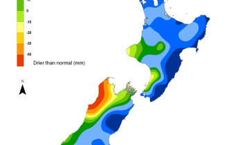
Across the North Island, soil moisture levels decreased everywhere during the past week due to widespread meagre rainfall. The most significant decreases were observed in the eastern North Island, but other notable decreases occurred in Taranaki, western Waikato, and eastern Northland. The driest soils across the North Island compared to normal for this time of the year are found in parts of Northland, Waikato, Taranaki, Bay of Plenty, and northern Hawke’s Bay, while the wettest soils for this time of the year are located in small portions of the east coast.
Areas deemed hotspots now encompass large portions of the entire North Island. Small parts of eastern Northland, western Waikato, the Central Plateau, and Gisborne fall just short of the hotspot threshold, but very dry soils are nearly universal across the North Island at this time.
Across the South Island, soil moisture levels decreased slightly in most areas during the past week, but did improve slightly in Fiordland and the central West Coast. The driest soils across the South Island compared to normal for this time of the year continue to be found in western Tasman and northern Buller District, while the wettest soils for this time of the year are found in Fiordland.
Hotspots remain entrenched across the northern tier of the South Island, including across northern Tasman, Nelson, and much of Marlborough. Additional hotspots are also located in coastal Hurunui, parts of Banks Peninsula, south-central Canterbury, and coastal southern Otago.
Outlook and Soil Moisture
In the North Island, rainfall amounts during the next week could be highly variable due to uncertainty regarding the interaction between moisture from Tropical Cyclone Oma and a separate area of low pressure expected to form near New Zealand on Sunday and Monday (24-25 February). Moisture streaming away from Oma may affect parts of Northland and Auckland on Friday and Saturday (22-23 February), with rainfall locally reaching or exceeding 20 mm. Low pressure forming near or east of New Zealand over the weekend will likely deliver moderate to heavy rainfall to large portions of the North Island on Sunday and Monday. Central and southern areas could see localised totals in excess of 50 mm, with lower amounts farther north. The rest of next week will likely feature mostly dry weather.
Moderate to locally heavy rainfall will likely lead to at least marginal improvements in soil moisture across large portions of the North Island during the next week. This may result in at least a temporary weakening or disappearance of hotspots in eastern and southern areas, with local improvements possible in northern areas.
In the South Island, waves of rain off the Tasman Sea will bring moderate rainfall amounts to the West Coast over the next few days. The aforementioned low pressure forming near New Zealand over the upcoming weekend may deliver moderate rainfall to northern and eastern areas particularly on Sunday (24 February), with localised amounts up to 30-40 mm. Northern Canterbury may continue to see showers into Monday, before a front brings showers to Southland and Otago on Wednesday (27 February).
Due to the expected rainfall, mild improvements to the hotspots in the northern tier of the South Island are possible during the next week. This could also be the case for the other hotspots located in the eastern South Island. At a minimum, current hotspots are unlikely to worsen in the next week.


As of 17 February, the New Zealand Drought Index (NZDI) map below shows that meteorological drought conditions are now in place across parts of Nelson, Tasman, and the Aupouri Peninsula, along with widespread dry to extremely dry conditions. Only minimal improvements are possible in the next week. Please note: some hotspots in the text above may not correspond with the NZDI map, mainly because the NZDI uses additional dryness indices including one which integrates the rainfall deficit over the past 60 days. Changes are therefore slower to appear in the NZDI compared to the instantaneous status maps of soil moisture anomaly.
Background
Hotspot Watch a weekly advisory service for New Zealand media. It provides soil moisture and precipitation measurements around the country to help assess whether extremely dry conditions are imminent.
Soil moisture deficit: the amount of water needed to bring the soil moisture content back to field capacity, which is the maximum amount of water the soil can hold.
Soil moisture anomaly: the difference between the historical normal soil moisture deficit (or surplus) for a given time of year and actual soil moisture deficits.
Definitions: “Extremely” and “severely” dry soils are based on a combination of the current soil moisture status and the difference from normal soil moisture (see soil moisture maps)
Hotspot: A hotspot is declared if soils are "severely drier than normal" which occurs when Soil Moisture Deficit (SMD) is less than -110 mm AND the Soil Moisture Anomaly is less than -20 mm