NIWA's Hotspot Watch 8 January 2016
A weekly update describing soil moisture across the country to help assess whether severely to extremely dry conditions are occurring or imminent. Regions experiencing these soil moisture deficits are deemed “hotspots”. Persistent hotspot regions have the potential to develop into drought.
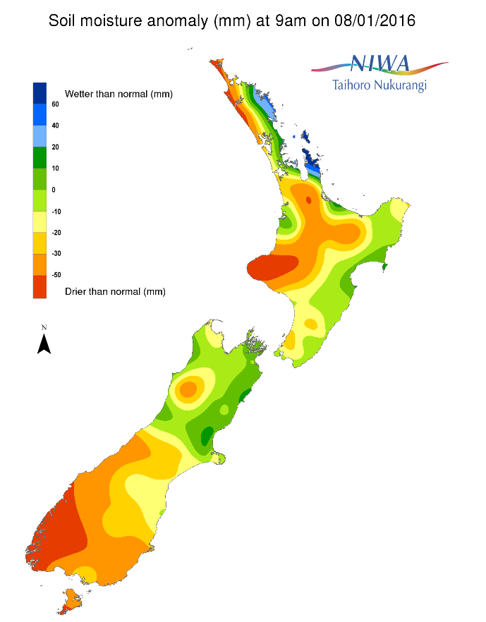
Soil Moisture
Soil moisture levels across the North Island have increased significantly when compared to this time last week for eastern Northland, Auckland and Waikato regions where soil moisture levels are now normal to above normal for this time of year. Soil moisture levels have also increased, albeit not as much, over the past several days from the Gisborne to Wellington regions where soil moisture levels are near normal for this time of year. Meanwhile, much drier to severely drier than normal soils for the time of year dominate central parts of the island. This includes much of the Taranaki, northern Manawatu-Wanganui, and northern-central parts of the Waikato regions.
In the South Island, changes in soil moisture over the past week were generally bounded by a line from Christchurch to Greymouth. Along and north of this line, soil moisture levels increased sharply to near normal levels for this time of year. Near and south of this line, soil moisture levels have changed little or even decreased. In this area, soil moisture levels remain much drier to severely drier than normal for this time of year with pockets of severely drier than normal soils for this time of year over interior Otago.
Outlook
For the North Island, after a rather wet Friday scattered morning and early afternoon showers are likely for the central and northern part of the island with scattered showers likely for (chiefly) the lower part of the island Sunday. Dry weather is expected for most of the island Monday.
Thereafter, Tropical Cyclone Ula or her remnants, is forecast to move south and east from the tropics. There is reasonable confidence that this system will have some direct or indirect impact on the northern and eastern part of the island. While exact details are unknown, it’s distinctly possible that areas from Northland to possibly the Bay of Plenty will receive rain on Tuesday. Preliminary indications suggests some areas may receive as much as 10-25 mm from the event. The rest of the island is likely to receive little rainfall from this system. Dry weather is forecast to return for most of the island Wednesday with scattered showers possible Thursday, and to a lesser extent, Friday.
Soil moisture levels are likely to increase over most of the central and northern part of the island as a result of rain today (Friday) and the aforementioned tropical system next week. The rest of the island will likely see soil moisture levels remain steady or decrease, with areas from Gisborne to Wellington having the greatest risk for soil moisture reduction.
After a wet Friday and showers on Saturday for areas west of the Divide of the South Island, generally dry weather is forecast through to Tuesday evening for most of the island. A cold front is forecast to impact the island Wednesday, including the mid and lower sections of eastern Canterbury. However, rainfall totals from the event will likely remain less than 10 mm and may not exceed 5 mm for many locations. Dry weather will likely return Thursday and Friday, though showers may impact areas west of the Divide Friday. As a result soil moisture levels are likely to increase for most areas along and west of the Divide, with soil moisture levels likely remaining largely unchanged or decreasing for most areas east of the Divide. The Otago region has the greatest probability of experiencing a reduction in soil moisture over the next week.
For the North Island, because of today’s (Friday) ongoing rain, there are not any meaningful hotspot areas to report. However, areas from Gisborne to Wellington will need to be monitored for possible hotspot development this week. Additionally, and depending on how much rainfall occurs through to Saturday morning, parts of the Waikato will need to be monitored for possible hotspot development over the coming days.
For the South Island, a hotspot exists between Ashburton and Timaru in eastern Canterbury. A more significant hotspot region is present in Otago and Southland.
NB: due to the timing and reporting of daily 24 hour rainfall amounts (9 am each day) and time required to compute soil moisture deficit values, the rain that occurred on Friday 8 January through to Saturday 9 of January will not be fully reflected in the soil moisture anomaly maps until Sunday 10 January.
Background
Soil moisture deficit
Soil moisture deficit is the amount of water needed to bring the soil moisture content back to field capacity, which is the maximum amount of water the soil can hold.
Soil moisture anomaly
Soil moisture anomaly the difference between the historical normal soil moisture deficit (or surplus) for a given time of year and actual soil moisture deficits.
Definitions
“Extremely” and “severely” dry soils are based on a combination of the current soil moisture status and the difference from normal soil moisture (see soil moisture maps at https://www.niwa.co.nz/climate/nz-drought-monitor/droughtindicatormaps)
Soil moisture anomaly maps
Pictured below are soil Moisture Anomaly Maps, relative to this time of year. The maps show soil moisture anomaly for the past two weeks.