New Zealand joins global seabed mapping initiative
New Zealand has joined a global initiative to map the ocean floor of the entire world by the year 2030.
Called Seabed 2030, the project is a collaboration between The Nippon Foundation in Japan and the General Bathymetric Chart of the Oceans (GEBCO).
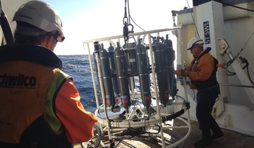
The work will be coordinated by four regional centres around the globe, with NIWA, GNS Science, and Land Information New Zealand jointly governing the South and West Pacific Ocean Regional Data Assembly and Coordination Centre.
The centre will be based at NIWA in Wellington and look after an area equivalent to a quarter of the world’s oceans. It covers the Pacific Ocean from South America to Australia, north of latitude 50°S to 10° north of the Equator and the western part of the Northern Pacific Ocean to Japan and includes the world’s two deepest trenches—the Mariana and Kermadec Trenches, both of which are more than 10km deep.
The project aims are to combine all existing bathymetric data into a unified database, promote efforts to collect new data on the ocean floor and to generate maps of all ocean floor features larger than 100m.
In a statement issued this week, The Nippon Foundation said less than 15% of the world’s ocean floor was adequately mapped.
The foundation said the project was aiming for 100% coverage by 2030 by compiling data from around the globe and turning it into digital maps that can be made available to the public. The project will also identify gaps where data are lacking. It plans to contribute $US18.5 million for the first 10 years of the project.
“The topography of the ocean floor is far less known than the surfaces of Mercury, Venus, Mars, and the moons of several planets including Earth’s,” the foundation said.
Knowledge of the shape of the seafloor was crucial for understanding ocean circulation patterns that distribute heat between the tropics and the poles—a key component of Earth’s climate system.
Detailed measurements of ocean depth were also crucial for modelling tsunami inundation of coastal areas.
“In addition, ocean bathymetry is important for the study of tides, wave action, sediment transport, underwater geohazards, cable routing, fisheries management, resource exploration, military applications, and the establishment of sovereign rights over the seafloor.”
The completed maps will be released on NF-GEBCO Seabed 2030’s official website and will also be made available for online resources such as Google Earth and ESRI’s Ocean Basemap.
NIWA marine geologist Dr Geoffroy Lamarche said the work would require close collaboration and involvement of all coastal states coordinated by the centre.
“Such information is critical to enable coastal states to properly manage and protect the benthic (at and near the seafloor) environment from the coast to the greatest abyssal depths of the ocean.”
Manager of the Marine Geoscience group at GNS Science, Vaughan Stagpoole, said New Zealand participation in the project would help develop international collaborations and lead to technological innovation for mapping in areas where data could not be collected efficiently using existing technologies.
“Already, 24 government and research organisations, institutions, universities, and businesses around the world have agreed to participate in this project, and this number is expected to grow significantly,” Dr Stagpoole said.
Land Information New Zealand (LINZ) is New Zealand’s charting authority. National Hydrographer Adam Greenland said it already had work under way that would contribute to this global initiative.
“We’re currently mapping the seabed in several areas around the country, with plans for much more over the next 10 years to support safety at sea. The data we collect and have collected in the past, will be made available, supporting the aims of Seabed 2030,” says Mr Greenland.
Contacts
Dr Geoffroy Lamarche, Marine Geologist, NIWA
Dr Vaughan Stagpoole, Marine Geophysicist, GNS Science
Dr Adam Greenland, National Hydrographer, LINZ
GEBCO
The General Bathymetric Chart of the Oceans (GEBCO) is an organisation that has worked with The Nippon Foundation for more than a decade. Founded more than 100 years ago with a vision of portraying the world’s ocean floor, GEBCO operates under the auspices of its two parent organisations, the International Hydrographic Organization (IHO) and the Intergovernmental Oceanographic Commission (IOC) of UNESCO. It is the only international project mandated to map the ocean floor of the entire world.
The Nippon Foundation
Since its establishment in 1962 by Ryoichi Sasakawa as the Japan Shipbuilding Industry Foundation, The Nippon Foundation has put considerable effort into the ocean and maritime field, as well addressing a wide-ranging variety of social issues in Japan and internationally. This includes humanitarian activities, public welfare, and international cooperation. The Foundation’s main objective in the ocean and maritime sphere is to pass on the riches of the oceans to future generations by cultivating human resources able to create a better future for the seas, and building networks to enable those people and organisations to work together. It addresses the problems related to the ocean by implementing global programs in conjunction with leading research institutions and universities, governments, NGOs, and UN agencies.