The New Zealand Hydrological Society Conference takes place in Nelson this week. The theme for the conference is "Water: Know your limits". Water conservation and management is a hot topic.
Hydrologists and water managers are powerful contributors to the task of setting water resource limits and managing water within those limits.
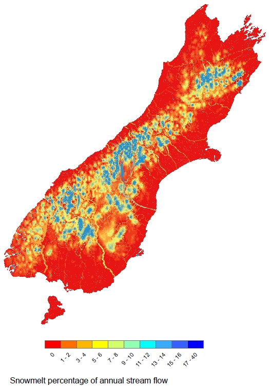
Understanding where our water comes from is an important foundation for water management.
NIWA's hydrology scientist and conference speaker, Dr Tim Kerr, has recently finished a South Island assessment of the contribution of snowmelt to river flows.
Snowmelt affects river flow seasonality. "Increased flow from snowmelt in summer is beneficial for irrigation, but decreased flow in winter, when snow builds up, is problematic for hydro-electricity," says Kerr.
Snowmelt can also affect the sizes of floods. "Knowledge of how snowmelt might affect the size of a flood is an important consideration for building structures near rivers, or when forecasting flood events.
"Add into the mix the potential for climate warming to change these seasonal and flooding effects as less snow and more rain falls, and you can see that it is worth having an idea where snowmelt is important. To date, these assessments have been done on a case by case basis, an expensive and inconsistent approach," says Dr Kerr.
If snow contributions decrease overall as a result of climate warming, this is likely to reduce summer low flows in snow-fed rivers. For water resources users that are subject to minimum flow rules, this will increase the likelihood of restrictions on the amount of water they can take during that period.
This new assessment was made using 20 years of daily temperature and precipitation data from the Virtual Climate Station data, a product produced by Dr Andrew Tait, NIWA's Principal Scientist for Climate Applications.
The estimates show that of the large rivers that reach the sea, the Waitaki has the highest snowmelt contribution with 12%, while the Cook River on the West Coast is next highest with 11%.
Of the hydro-electricity lakes, Lake Pukaki has the highest snowmelt contribution of 18%, whereas Fraser Dam, an example of an irrigation storage dam in Otago, receives 14% of its inflows from snowmelt. Overall, it is estimated that 3.4%, or 1 litre in every 30, of the South Island's river flow originates from snowmelt.
Dr Tim Kerr is a speaker at the New Zealand Hydrological Society Conference, being held in Nelson 27–30 November. Dr Kerr's speech is on Tuesday 27 November at 1.10pm.
NIWA's Dr Hilary McMillan will be chairing a session on Waterscape.
There will also be a session on water resource limits chaired by Environment Canterbury (ECAN).
See the New Zealand Hydrological Society Conference: "Water: Know your limits" website for more information.