New Climate Change Atlas for our massive ocean real estate
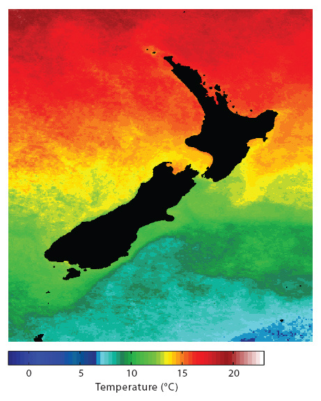
In a world first, NIWA has designed a regional climate change ocean 'atlas' - for our Exclusive Economic Zone (EEZ).
It maps out New Zealand's resources within the EEZ, highlights climate change related issues, and shows how plants and animals in the area may respond to future changes facing New Zealand's waters. This version of the atlas is a first look at what will become an interactive web-based tool.
The atlas will simplify and collate information about climate change in the region. As it is developed it will give users the ability to customise and compile the necessary information to focus on particular questions. It can help frame discussion and inform policy makers about what is needed to reduce uncertainties on the future of the marine life in our EEZ.
"It will offer New Zealand a repository of three interlinked strands of information, by bringing together who lives where, how vulnerable they are to environmental change, and how our EEZ environment is projected to change. We can construct a wide range of simple and insightful scenarios to address a wide range of topics – it's like a toolkit," says Dr Boyd.
Users will eventually be able to control their view of multiple layers of information overlaid on a digital map. They will be able to view the information based on different time periods so that they can come to grips with how our environment will change.
The seas surrounding New Zealand could warm by up to 4oC in the coming century. The magnitude of these changes will differ between water bodies. These changes, and the response of plants and animals to them, will mean that there are some areas where the effects will be greater than others.
The value of the marine resources harvested within the EEZ is estimated to be over NZ$4 billion per annum and supports over 10,000 jobs.
"[In the future] there may be areas where some marine life is becoming increasingly vulnerable," says Dr Boyd. Adjusting to that change may mean harvesting can take place only in certain areas.
"There could be direct or indirect effects on fisheries. The productivity of microscopic plants - phytoplankton, which form productive blooms of over thousands of square kilometres, may well be reduced by waters warming and the rise in CO2," says Dr Boyd.
Commercially valuable fish species are susceptible to changes to the environment such as year-to-year variability in ocean conditions, whether directly through impacts on growth, mortality, distribution or spawning success, or indirectly through flow on effects through the food chain. The atlas is designed to provide information on projected changes in climate that can be used to help determine fluctuations in fish stocks over time.
Phytoplankton are the building block of the oceanic food chain, and their stocks, productivity, size, and diversity determine the amount of carbon and energy available to species further up the food chain.
The last ten years of monthly monitoring results have shown an increase in acidity in Subantarctic waters off Otago. This is probably due to the recorded increase in atmospheric CO2 and subsequent CO2 uptake by the ocean. This trend is consistent with that observed in long-term time series studies in other regions of the ocean. Ocean acidification has been shown to affect reproduction, behavior, and physiological functions of some species.
Download
Download the NIWA Climate Change Atlas [2.6 MB PDF]
Background facts
- Surface waters will warm, freshen (i.e., become less salty), and so become less dense. This will increase the density gradient between surface and deeper waters (i.e.,
- Stratification), which will reduce the upward supply of plant nutrients to the surface from deeper waters
- The surface layer where the phytoplankton live will become thinner and so the phytoplankton will receive more light
- The warmer ocean will contain less dissolved oxygen, and the volume of the mid-water column oxygen-deficient zones will increase
- Increasing carbon dioxide in the atmosphere will enter the ocean making it more acidic and causing carbonate shells to dissolve at shallower depths
- There will be large-scale changes in wind fields, affecting ocean currents and vertical mixing
- Storm frequency and dust deposition will increase, influencing nutrient supply