The intense low pressure system that developed in the Tasman sea late yesterday had become as strong as a category 2 tropical cyclone by 8am today, says NIWA meteorologist Ben Noll.
At that time the pressure at the centre of the storm was estimated at 967 millibars. Mr Noll said overall it was an unusual, but not unheard of, pattern of weather for mid-summer.
Why such a strong storm?
- A very strong jet stream (for the time of year) stretched from the southern Indian Ocean to the Tasman Sea.
- This contributed to a strong south to north temperature gradient across the Tasman Sea where rapid intensification took place.
- Warmer than average sea surface temperatures in the western Tasman Sea.
- A pulse in the Madden-Julian Oscillation (MJO). The MJO is characterised as an eastward moving area of enhanced cloud and rainfall near the equator that usually recurs every 30 to 60 days.
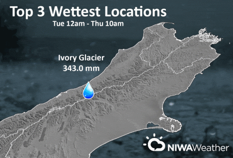
As a result, very heavy rain occurred across the South Island. The heaviest rainfall was across the Southern Alps.
Top three rain amounts (from 12:00 am Tuesday to 10:00 am today):
- Ivory Glacier, 343 mm
- Arthur’s Pass, 310.2 mm, including 44.8 mm in one hour late Wednesday evening. This was the wettest hour at the location on record since the climate station was erected in July 2005.
- Mueller Hut, 309.5 mm
Other heavy rain amounts (12:00 am Tuesday to 10:00 am today)
- Greymouth, 128.2 mm
- Hokitika, 115.4 mm
- Reefton, 104.0 mm
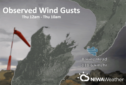
Strong wind gusts were also observed across parts of the South Island and lower North Island.
Top wind gusts
- Baring Head, 138.6 km/hr
- Akitio, 131.8 km/hr
- Wellington (Greta Point), 113.4 km/hr
- Mahanga, 113.0 km/hr
- Westport, 93.2 km/hr
In the storm’s wake, very chilly southwest winds are expected to spread up the country and be in place by tomorrow morning. Some snow is even possible across the Southern Alps tonight. Spotty showers are forecast across the country tomorrow as an autumn-like day unfolds.
After that, another potent storm is on the cards for late Saturday into Sunday, Mr Noll says.
“Some very heavy falls of rain are possible in similar locations that received heavy rain from the first storm.
“Some beneficial rain is possible across the North Island, particularly in those locations that are experiencing very to extremely drier than normal soils. This relief will be short-lived, as mostly dry conditions are expected to return to the driest locations next week (Auckland, Northland, Hawke’s Bay, and Gisborne).
In fact, Kerikeri received just 1 mm of rain this month or less than 1% of normal. The normal January rainfall is 112 mm.
Will proper summer weather return soon?
Through the end of January, patterns of southwest winds are expected to alternate with northwest winds. Temperatures, for the most part, will be cooler than average for the time of year, although the east of both islands will experience a few warmer than average days.
As we head into early February, there is some indication for settled weather patterns across New Zealand with a warming trend toward mid-month. As such, soils across the north and east of the North Island may continue to dry due to below normal rainfall.
For now, we will have to tough it out through an autumn-like chill in the heart of summer!