Auckland’s drought most extreme in modern times
22 May 2020
NIWA meteorologist Ben Noll has compiled the following background information on the Auckland drought for use by journalists.
- This is one of the most extreme drought events for Auckland in modern times and similar to one experienced in 1993/94.
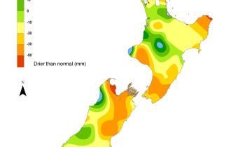
- Just 126mm of rain was recorded at NIWA’s Mangere weather station between 1 January and 21 May – that is 31% of normal. The normal period is 1981-2010 for January-May.
- NIWA data shows this is one of the most severe droughts since the early 20th Century.
- The origins of the drought began about 8000km away in the Indian Ocean late last year with a phenomenon known as the Indian Ocean Dipole (IOD). The IOD is an atmospheric seesaw that impacts sea surface temperatures, rainfall, and wind.
- As weather systems tracked toward New Zealand from the west and north, they lacked moisture because of cooler eastern Indian Ocean seas caused by the IOD.
- In late 2019 and early 2020, a lack of atmospheric rivers, or plumes of moisture that extend to the mid-latitudes from the tropics, has limited heavy rainfall events. This was a factor that was prominent in New Zealand during early 2017 that led to several extreme rainfall events.
- As New Zealand headed into summer the IOD persisted and had some help from the tropical Pacific. Although the El Niño Southern Oscillation was neutral, there was a lean toward an atypical form of El Niño called Modoki. In this form of El Niño, ocean temperature anomalies are larger in the central tropical Pacific than the east, which has flow-on impacts on circulation patterns around the globe. This pattern has been present for the better part of the last two years. There are indications that Modoki events are increasing as part of the climate change signal.
- Tropical cyclone activity between November 2019-April 2020 was near normal for the SW Pacific and New Zealand saw two ex-tropical cyclones (Uesi, Gretel) miss the driest areas.
- The Southern Annular Mode or SAM began a two month run of positive values during February – a positive SAM is associated with more tranquil weather in the New Zealand region.
- Reduced rainfall and thunderstorm activity in the Coral Sea means that low pressure systems approaching from the west have not been able to tap into sub-tropical moisture, leading to less rain for New Zealand.
- NIWA’s climate change expectations suggest spring average rainfall decreases for northern New Zealand, including Auckland. When this is combined with increased temperatures (and therefore greater requirements of water by plants) it is likely to result in more visible regional impacts from water shortages and drought.
- Two significant climate features may develop in the next 3-6 months: a negative IOD and La Niña. These two features could give northern and eastern New Zealand better odds for seasonal rainfall, but not right away. New Zealand might begin experiencing these effects during the 2nd half of winter or early spring. In the meantime, longer than normal dry spells will remain possible during the month of June.
Contact


Water levels plummet in the Upper Mangatawhiri Dam in the Hunua Ranges [Stuart Mackay, NIWA]

Lower Nihotupu Reservoir [Stuart Mackay, NIWA]

Upper Mangatawhiri Reservoir [Stuart Mackay, NIWA]