Bringing together leading scientific organisations and regional councils, this project aims to develop a sophisticated computer modelling framework that will enable users to accurately predict how much freshwater is available, where it has come from, and how quickly it moves through New Zealand catchments.
NZ Water Model - Hydrology (NZWaM-Hydro) is a partnership of NIWA (lead), GNS Science and Manaaki Whenua - Landcare Research, and the regional councils of Southland, Horizons and Gisborne. The project timeframe is 2016-2024. The key aim of the NZWaM-Hydro project is to enable the prediction of reliable river flows, hydrological fluxes, groundwater levels and transport processes time series. Predictions can be run at national to sub-catchment scale to support end user applications at relevant scales.
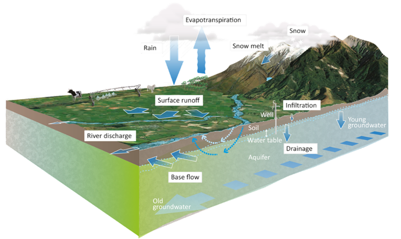
The image ablove demonstrates some of the primary hydrological processes represented in the model
Work in this project will enhance the ability of NZWaM-Hydro to predict how climate, land-use, water use and other environmental changes will affect aquatic ecosystems, and water-resources available for use by businesses and communities. It will also improve the accuracy of the model's river-flow simulations that enable communities to develop sustainable use of the resource as well as to better prepare for potential floods and droughts.
The Challenge
The National Policy Statement for Freshwater Management (NPS-FM) requires regional council water managers to set limits on the use and quality of freshwater, and then allocate water takes based on those limits. In addition, the need for robust hydrological information is required by a wide range of users across a wide range of use This challenge is significant in New Zealand catchments, due to the interactions between land, vegetation, climate, surface water and groundwater. In addition, measurements of surface and groundwater flow and contaminants are relatively sparse. In such data sparse regions, limit-setting and water-allocation can be complex and/or require sophisticated computer models to accurately predict the movement of water and contaminants from their source, to waterways, lakes and estuaries. Such models also need to be flexible enough to simulate the effects of different land-use and climate scenarios on flow and predict into the near and far future, and complex enough to represent the integration of natural and anthropogenic processes. The different models require:
- detailed maps of streams and aquifers, - observed river flow data for model validation, - information on soils and other catchment properties, and - direct and indirect information on processes (for example, runoff and evapotranspiration).
A highly adaptable solution
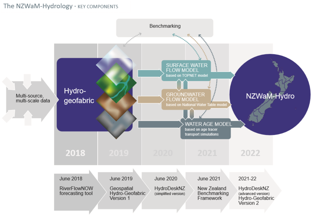
NZWaM-Hydro will combine an ensemble of surface-water and/or groundwater models with a water-age model to provide hydrological tracers and water-source information across New Zealand. The project will also build a geospatial and geo-temporal database to organise and harmonise data, and provide transferable, scalable and cost-effective applications. In addition the project will also provide:
- Pathways to link environmental data with sub-models representing different hydrological processes.
- Simulations of surface-water and groundwater flows at catchment scale (down to first-order catchments) in both gauged and ungauged catchments, to support water-resource management and hydrological investigation.
- A 'hydro-geofabric' that will provide a consistent, national geospatial information framework to further develop capability in process understanding, and measurement across spatial and temporal scales.
- Software such as HydroDeskNZ (a cloud based tool ), allowing users to simulate surface and groundwater flow, on the cloud.
- Environmental flow forecasts under varying land-uses and climate conditions and across a range of timescales (from a few days to decades ahead).
- Enhanced ability to assess hydrological model outputs using a state-of-the-art New Zealand 'Benchmarking Framework'.
The dashed lines in the diagram represent each of the four modules in NZWaM-Hydro which will be used to refine the other modules, and to refine data requirements.
The opportunity
At a national scale there is no existing model that has the functionality that NZWaM-Hydro will possess. At catchment and sub-catchment scale, the aim is to be able to produce robust and reliable time series data anywhere in space (with absolute accuracy improving with time) and associated uncertainty quantification. NZWaM-Hydro will be able to be applied anywhere in New Zealand with just one click through HydrodeskNZ. NZWaM-Hydro is a scalable, surface-groundwater modelling framework that uses water age as a tracer for routing water through river networks and aquifers. NZWaM-Hydro is enabled by NIWA's high performance computer facility.
Multi-source data: data is acquired from Regional Councils & LAWA, Crown Research Institutes, Land Resource Inventory, remote-sensing, the NIWA Climate Database and via collaboration industry sectors and other sources.
Hydro-geofabric: a national dynamic geospatial database containing geo-referenced harmonised data-sets. The database will be used to generate catchment-scale hydrological parameters across the country (e.g., soil moisture, land-cover and catchment characteristics)
Surface water flow model: combination of surface water models based (currently) on the updated national TopNet model – TopNet is a mechanistic rainfall-runoff model. TopNet is currently used in an uncalibrated state at a national scale (e.g. for flow corrections of trend analyses, water accounts), and with calibrated data for local scale studies (e.g. for environmental flow setting, driving the Cumulative Hydrological Effects Simulator, Hydroelectric power management, Freshwater Management Unit limit setting for flow and nutrients). Other surface water model using different model structures are currently being investigated to complete the surface water ensemble models.
Groundwater flow model: combination of groundwater models based on i) GNS Science National Water Table model (NWT), which is driven by geology and climate conditions this will describe fluctuations in depth to groundwater nationwide and feeds into the TopNet model using loose coupling principles and ii) NIWA’s TopNet-GW, a catchment scale groundwater storage model fully coupled to NIWA’s TopNet model.
Water Age model: based on GNS Science & NIWA water age chemistry data, and the TopNet and NWT models.
External People Involved:
Rogier Westerhoff - [email protected]
Linda Lilburne - [email protected]
-

NZWaM - Hydro: Use and applications
NZWaM-Hydro is scalable, and the hydrological relationships in the model are transferable between locations. -
NZWaM - Hydro: Our partners
The NZWaM – Hydro project is led by NIWA but all work is conducted in collaboration with our project partners. -
NZWaM - Benchmarking
The purpose of the benchmarking task is to develop and implement a state-of-the-art operational method (that can be applied at national scale) to test hydrological models in New Zealand -
NZWaM - Hydro-Geofabric
The purpose of the Hydro-Geofabric task is to gather, harmonise and augment existing multi-source spatial datasets to form a framework tailored for hydrological modelling. -
NZWaM - Groundwater flow model
The role of the NZWaM groundwater model is to improve surface water model simulations, by estimating groundwater storages and groundwater fluxes. -
NZWaM - Surface water flow model
This task aims to improve and enhance the accuracy of surface hydrological model discharge predictions, at both catchment and regional scales. -
NZWaM - Water-age model
The purpose of the water-age model is to represent water exchange between land, surface-water bodies and aquifers, by coupling the surface water and groundwater models.